Byron, Michigan

Last updated

Byron, Michigan
Village of Byron
Byron, MI location.png
Location within Shiawassee County
USA Michigan location map.svg
Red pog.svg
Byron
Location within the state of Michigan
Coordinates: 42°49′26″N83°56′48″W / 42.82389°N 83.94667°W / 42.82389; -83.94667
Country United States
State Michigan
County Shiawassee
Township Burns
Founded1824
Incorporated1873
Government
  Type Village council
  PresidentAnthony Prestonise
   Clerk Marsha Reed
Area
[1]
  Total0.76 sq mi (1.97 km2)
  Land0.71 sq mi (1.83 km2)
  Water0.06 sq mi (0.14 km2)
Elevation
[2]
830 ft (250 m)
Population
 (2020)
  Total545
  Density771.95/sq mi (297.94/km2)
Time zone UTC-5 (Eastern (EST))
  Summer (DST) UTC-4 (EDT)
ZIP code(s)
48418
Area code 810
FIPS code 26-12260 [3]
GNIS feature ID2397517 [2]
Website Official website

Byron is a village in Shiawassee County in the U.S. state of Michigan. The population was 581 at the 2010 census. The village is located within Burns Township. [4]

Contents

History

Founded in 1824, Byron received its first postmaster in 1837. One of the only towns in the county, Byron was the last stop on a stagecoach run from Detroit that ran west along what is now Rose Center road and Silver Lake road. The Village of Byron was incorporated in 1873. [5] The Toledo, Ann Arbor & Northern Michigan Railway was built through Byron following the pledge of a $15,001 bonus and the right of way, in 1885. [6]

Geography

According to the United States Census Bureau, the village has a total area of 0.75 square miles (1.94 km2), of which 0.70 square miles (1.81 km2) is land and 0.05 square miles (0.13 km2) (7.14%) is water. [4]

Demographics

Historical population
CensusPop.Note
1880 355
1890 41316.3%
1900 4324.6%
1910 427−1.2%
1920 376−11.9%
1930 3872.9%
1940 46921.2%
1950 439−6.4%
1960 54223.5%
1970 65520.8%
1980 6895.2%
1990 573−16.8%
2000 5953.8%
2010 581−2.4%
2020 545−6.2%
U.S. Decennial Census [7]
Soldiers and veterans of the Detroit Light Guard march in a funeral in Byron, 1900 The Detroit Light Guard - a complete record of this organization from its foundation to the present day - with full account of riot and complimentary duty, and the campaigns in the Civil and (14759619351).jpg
Soldiers and veterans of the Detroit Light Guard march in a funeral in Byron, 1900

2010 census

As of the census [8] of 2010, there were 581 people, 208 households, and 161 families living in the village. The population density was 830.0 inhabitants per square mile (320.5/km2). There were 238 housing units at an average density of 340.0 per square mile (131.3/km2). The racial makeup of the village was 95.7% White, 1.0% African American, 1.5% Native American, 0.2% Asian, 0.2% from other races, and 1.4% from two or more races. Hispanic or Latino of any race were 2.1% of the population.

There were 208 households, of which 48.1% had children under the age of 18 living with them, 51.4% were married couples living together, 17.8% had a female householder with no husband present, 8.2% had a male householder with no wife present, and 22.6% were non-families. 20.7% of all households were made up of individuals, and 5.8% had someone living alone who was 65 years of age or older. The average household size was 2.79 and the average family size was 3.19.

The median age in the village was 33 years. 33.9% of residents were under the age of 18; 7.3% were between the ages of 18 and 24; 26.1% were from 25 to 44; 24.6% were from 45 to 64; and 8.3% were 65 years of age or older. The gender makeup of the village was 48.5% male and 51.5% female.

2000 census

As of the census [3] of 2000, there were 595 people, 218 households, and 170 families living in the village. The population density was 806.2 inhabitants per square mile (311.3/km2). There were 231 housing units at an average density of 313.0 per square mile (120.8/km2). The racial makeup of the village was 96.64% White, 1.34% Native American, and 2.02% from two or more races. Hispanic or Latino of any race were 2.18% of the population.

There were 218 households, out of which 39.4% had children under the age of 18 living with them, 58.3% were married couples living together, 11.9% had a female householder with no husband present, and 22.0% were non-families. 18.8% of all households were made up of individuals, and 6.4% had someone living alone who was 65 years of age or older. The average household size was 2.73 and the average family size was 3.07.

In the village, the population was spread out, with 29.2% under the age of 18, 8.7% from 18 to 24, 31.1% from 25 to 44, 21.2% from 45 to 64, and 9.7% who were 65 years of age or older. The median age was 34 years. For every 100 females, there were 98.3 males. For every 100 females age 18 and over, there were 87.1 males.

The median income for a household in the village was $39,167, and the median income for a family was $41,563. Males had a median income of $34,286 versus $25,962 for females. The per capita income for the village was $17,137. About 5.8% of families and 6.7% of the population were below the poverty line, including 9.8% of those under age 18 and none of those age 65 or over.

Plaque commemorating Ellen May Tower Ellen May Tower sign Byron-front.jpg
Plaque commemorating Ellen May Tower

Notable people

Related Research Articles

<span class="mw-page-title-main">Maple Rapids, Michigan</span> Village in Michigan, United States

Maple Rapids is a village in Clinton County in the U.S. state of Michigan. The population was 672 at the 2010 census. The village is located in Essex Township about 10 miles (16.1 km) northwest of St. Johns. A portion of the village is within the Maple River State Game Area.

<span class="mw-page-title-main">Holly, Michigan</span> Village in Michigan, United States

Holly is a village in north Oakland County in the U.S. state of Michigan. The population was 5,997 at the 2020 census. The village is located within Holly Township. It is about 15 miles (24 km) south of Flint and 55 miles (89 km) northwest of Detroit.
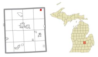
<span class="mw-page-title-main">Bancroft, Michigan</span> Village in Michigan, United States

Bancroft is a village in Shiawassee County in the U.S. state of Michigan. The population was 545 at the 2010 census. The village is located within Shiawassee Township.

<span class="mw-page-title-main">Burns Township, Michigan</span> Civil township in Michigan, United States

Burns Township is a civil township of Shiawassee County in the U.S. state of Michigan. As of the 2010 census, the township population was 3,457.

<span class="mw-page-title-main">Caledonia Township, Shiawassee County, Michigan</span> Charter township in Michigan, United States

Caledonia Charter Township is a charter township of Shiawassee County in the U.S. state of Michigan. The population was 4,475 at the 2010 census.

<span class="mw-page-title-main">Corunna, Michigan</span> City in Michigan, United States

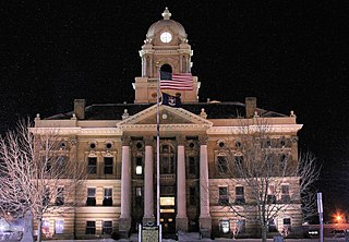
Corunna ( CORE-UN-NUH) is a city and county seat of Shiawassee County in the U.S. state of Michigan. The population was 3,497 at the 2010 census. The city is surrounded by Caledonia Charter Township and is slightly east of the city of Owosso.

<span class="mw-page-title-main">Fairfield Township, Shiawassee County, Michigan</span> Civil township in Michigan, United States

Fairfield Township is a civil township of Shiawassee County in the U.S. state of Michigan. As of the 2010 census, the township population was 755.

<span class="mw-page-title-main">Hazelton Township, Michigan</span> Civil township in Michigan, United States

Hazelton Township is a civil township of Shiawassee County in the U.S. state of Michigan. The population was 2,071 at the 2010 census.

<span class="mw-page-title-main">Laingsburg, Michigan</span> City in Michigan, United States

Laingsburg is a city in Shiawassee County in the U.S. state of Michigan. The population was 1,283 at the 2010 census.

<span class="mw-page-title-main">Middlebury Township, Michigan</span> Civil township in Michigan, United States

Middlebury Township is a civil township of Shiawassee County in the U.S. state of Michigan. As of the 2010 census, the township population was 1,510.

<span class="mw-page-title-main">Morrice, Michigan</span> Village in Michigan, United States

Morrice is a village located in Shiawassee County in the U.S. state of Michigan. The population was 927 at the 2010 census. The village is located within Perry Township. The center of population of Michigan is located near Morrice.

<span class="mw-page-title-main">New Haven Township, Shiawassee County, Michigan</span> Civil township in Michigan, United States

New Haven Township is a civil township of Shiawassee County in the U.S. state of Michigan. The population was 1,329 at the 2010 census. The township was organized in 1848.

<span class="mw-page-title-main">New Lothrop, Michigan</span> Village in Michigan, United States

New Lothrop is a village in Shiawassee County in the U.S. state of Michigan. The population was 565 at the 2020 census. The village is located within Hazelton Township.

<span class="mw-page-title-main">Perry, Michigan</span> City in Michigan, United States

Perry is a city in Shiawassee County in the U.S. state of Michigan. The population was 2,188 at the 2010 census. The city is surrounded by Perry Township, but the two are administered autonomously.

<span class="mw-page-title-main">Shiawassee Township, Michigan</span> Civil township in Michigan, United States

Shiawassee Township is a civil township of Shiawassee County in the U.S. state of Michigan. The population was 2,840 at the 2010 census.

<span class="mw-page-title-main">Venice Township, Michigan</span> Civil township in Michigan, United States

Venice Township is a civil township of Shiawassee County in the U.S. state of Michigan. The population was 2,578 at the 2010 census.

<span class="mw-page-title-main">Vernon, Michigan</span> Village in Michigan, United States

Vernon is a village in Shiawassee County in the U.S. state of Michigan. The population was 783 at the 2010 census. The village is located within Vernon Township.

<span class="mw-page-title-main">Vernon Township, Shiawassee County, Michigan</span> Civil township in Michigan, United States

Vernon Township is a civil township of Shiawassee County in the U.S. state of Michigan. The population was 4,614 at the 2010 census. The village of Vernon is located within the township. The township also surrounds the city of Durand, but the two are administered autonomously.

<span class="mw-page-title-main">Ovid, Michigan</span> City in Michigan, United States

Ovid is a city in the U.S. state of Michigan. Nearly all of the city is located within Clinton County with only a very small portion extending east into Shiawassee County. The population was 1,603 at the 2010 census.

Lennon is a village in the U.S. state of Michigan. The population was 511 at the 2010 census. The village is located along M-13 within Venice Township in Shiawassee County to the west and Clayton Township in Genesee County to the east.

References

  1. "2020 U.S. Gazetteer Files". United States Census Bureau. Retrieved May 21, 2022.
  2. 1 2 U.S. Geological Survey Geographic Names Information System: Byron, Michigan
  3. 1 2 "U.S. Census website". United States Census Bureau . Retrieved January 31, 2008.
  4. 1 2 "Michigan: 2010 Population and Housing Unit Counts 2010 Census of Population and Housing" (PDF). 2010 United States Census . United States Census Bureau. September 2012. p. 42 Michigan. Retrieved May 1, 2020.
  5. "Ghost towns and post offices of Shiawassee County". The Argus-Press. September 15, 2000. p. 3. Retrieved April 30, 2015.
  6. 150th Anniversary of Founding of Byron. The Historical Committee of the Byron Area Centennial Corporation. 1973.
  7. "Census of Population and Housing". Census.gov. Retrieved June 4, 2015.
  8. "U.S. Census website". United States Census Bureau . Retrieved November 25, 2012.
  9. King, Randy (April 5, 2013). "Success snowballs for teen driver". The Roanoke Times . Roanoke, VA. Archived from the original on June 30, 2013. Retrieved April 7, 2013.
  10. "GNIS Detail – Ellen May Tower Historical Marker". geonames.usgs.gov. Retrieved February 6, 2021.