CFB Gander

Last updated
CFB Gander
Air Force Ensign of Canada.svg
Gander, Newfoundland and Labrador in  Canada
Gander International Airport (satellite view).jpg
CFB Gander 9 Wing crest.png
Canada Newfoundland and Labrador location map 2.svg
Red pog.svg
CFB Gander
Location in Newfoundland and Labrador
Coordinates 48°56′13″N054°34′05″W / 48.93694°N 54.56806°W / 48.93694; -54.56806
Type Military air base / civilian airport
Site information
Owner Department of National Defence
OperatorRoyal Canadian Air Force ensign.svg  Royal Canadian Air Force
1941 (1941) – present
Civilian operatorGander Airport Corporation
Website http://www.rcaf-arc.forces.gc.ca/en/9-wing/index.page?
Site history
Built1936 (1936) – 1941 (1941)
Built byRoyal Canadian Air Force ensign.svg  Royal Canadian Air Force
In use1936 (1936) – present
Battles/wars Battle of the Atlantic
Garrison information
Current
commander
Lieutenant Colonel Rhea MacLean
Garrison9 Wing
Occupants 103 Search and Rescue Squadron
5 Canadian Rangers
CFS Leitrim Detachment
International Ice Patrol (1982−1989)
226 Aircraft Control and Warning Squadron (1953−1990)
4th Antisubmarine Squadron (1943)
6th Antisubmarine Squadron (1943)
19th Antisubmarine Squadron (1943)
No. 10 Squadron (1941−1945)
No. 5 Squadron (1941−1945)
No. 116 Squadron (1941−1945)
No. 126 Squadron (1942−1945)
No. 127 Squadron (1942−1945)
No. 129 Squadron (1942−1945)
21st Reconnaissance Squadron
Airfield information
Identifiers IATA: YQX, ICAO: CYQX
Elevation496 ft (151 m) AMSL
Runways
Direction Length and surface
03/2110,200 ft (3,100 m)  Asphalt concrete
13/318,900 ft (2,700 m) Asphalt concrete
09/271,848 ft (563 m) Asphalt concrete [1]
CFB Gander Diagram Gander International Airport (CYQX) aero chart.png
CFB Gander Diagram

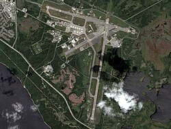
Canadian Forces Base Gander (also CFB Gander, IATA : YQX, ICAO : CYQX), is a Canadian Forces base located in Gander, Newfoundland and Labrador. It is operated as an air force base by the Royal Canadian Air Force and is home to search and rescue operations that cover a vast swath of the western North Atlantic and southern Arctic and a Canadian Coastal Radar station amongst other things. It is home to 9 Wing Gander.

Contents

CFB Gander is co-located at Gander International Airport.

RCAF Station Gander

The Newfoundland Airport was established by the Dominion of Newfoundland in 1936 and it became a strategically important airfield for piston-engined aircraft in the late 1930s.

Shortly after World War II was declared, the Government of Newfoundland turned the operation of the airfield over to the Royal Canadian Air Force (RCAF) in 1940, which had been tasked by the United Kingdom the responsibility to provide aerial defense for the dominion. The No. 10 Bomber and Reconnaissance (BR) Squadron began operating from the airfield, flying Douglas Digbys and later, Liberators with responsibility to protect supply convoys in the North Atlantic from enemy U-boats.

The airfield was renamed RCAF Station Gander in 1941 and it became heavily used by Ferry Command for transporting military aircraft from Canada and the United States to the European theatre. By 1943, Gander was the largest RCAF station in the world (in terms of physical size) and the Canadian Army maintained a strong presence at the airfield, providing anti-aircraft and airfield defense.

Several units were based at RCAF Station Gander during the war. No. 10 Squadron remained until August 1945 and was reinforced at times by No. 5 Squadron and No. 116 Squadron flying Cansos for anti-submarine patrols and search and rescue. From 1942 Hurricane fighters of the Royal Air Force No. 126 Squadron, No. 127 Squadron, and No. 129 Squadron were based at RCAF Station Gander. Throughout the war the Royal Canadian Navy (RCN) maintained a communications station at RCAF Station Gander, Its main task was high-frequency direction finding (HFDF) and communications monitoring of German U-boat radio transmissions.

The United States Army Air Forces Antisubmarine Command assigned several squadrons of long-range antisubmarine aircraft (B-24 Liberator, B-18 Bolo) to fly killer-hunter flights over the Grand Banks and also provide convoy escort overflights from Newfoundland. After the fall of 1943, these missions were undertaken by the United States Navy.

The RCAF handed operation of the airfield back to the Government of Newfoundland in March 1946 and removed its presence at what was promptly renamed Gander Airport (it was later upgraded to international status), although the RCN's radio monitoring station remained in operation. The airfield was taken over by Canada's federal government under the Department of Transport in 1949 after Newfoundland became Canada's tenth province. Facilities and runways were enlarged and modified for larger aircraft.

When Newfoundland joined Confederation, the RCN formally acquired the property known as the "Old Navy Site" and Naval Radio station Gander, call sign CGV, was born. Naval Radio Station (NRS) Gander consisted of four buildings, four sailors and a few civilian personnel.

Aerodrome

In approximately 1942 the aerodrome was listed as RCAF Aerodrome - Gander, Newfoundland at 48°57′N54°34′W / 48.950°N 54.567°W / 48.950; -54.567 with a variation of 30 degrees west and elevation of 452 ft (138 m). The field was listed as "All hard surfaced" and had four runways listed as follows: [2]

Runway NameLengthWidthSurface
5/234,500 ft (1,400 m)600 ft (180 m)Hard Surfaced
9/274,800 ft (1,500 m)1,200 ft (370 m)Hard Surfaced
12/304,700 ft (1,400 m)600 ft (180 m)Hard Surfaced
18/364,450 ft (1,360 m)600 ft (180 m)Hard Surfaced

Pinetree Line Radar site

In 1952, the United States Air Force constructed a General Surveillance radar station near the airfield as part of the Pinetree Line, designated "N-25". The new station was reassigned in 1953 to the Royal Canadian Air Force and took up the retired name RCAF Station Gander (designated "C-25"). The station functioned as a Ground-Control Intercept (GCI) and warning station housing the 226 Aircraft Control and Warning Squadron. As a GCI station, the squadron's role was to guide interceptor aircraft toward unidentified intruders picked up on the unit's radar scopes.

It was equipped with the following radars:

On 1 July 1990, the site was inactivated and closed. [3]

Canadian Forces Station Gander

On February 1, 1968, the RCN, RCAF and Canadian Army were unified and reorganized into the Canadian Forces. RCAF Station Gander, operating the Pinetree Line radar station and the Naval Radio Station Gander, was renamed Canadian Forces Station Gander, or CFS Gander.

In 1970 a new expanded communications monitoring facility was constructed for Communications Command, replacing Naval Radio Station Gander in 1971. CFS Gander's Pinetree Line radar and its new communications facilities provided support to NORAD fighter-interceptors operating from CFB Chatham and CFB Bagotville with the CF-101 Voodoo.

In 1977, Gander saw its first military flying unit return to the area since the war when a detachment of 424 Squadron, flying CH-113 Labrador helicopters moved to CFS Gander to provide search and rescue (SAR) operations (this being in response to Canada declaring its 200-nautical-mile (370 km) Exclusive Economic Zone offshore, resulting in increased Canadian fishing activities). Having found a permanent home at Gander, the SAR helicopters were no longer a 424 Squadron detachment and a new unit identifier was required. Thus, in May 1977, 103 Search and Rescue Flight was reactivated at Gander. Air Command (AIRCOM) also regained control of CFS Gander from Communications Command in May 1977, although Communications Command continued to operate the radio intercept facility. 103 Squadron was housed in a separate facility constructed some distance from the civilian airfield terminal.

Canadian Forces Base Gander

Canadian CH-149 Cormorant at CFB Gander CH149 SAR 103 Gander Newfoundland Canada.jpg
Canadian CH-149 Cormorant at CFB Gander

By 1984 CFS Gander was the largest Canadian Forces Station in the Canadian Forces. Because Gander was such a large establishment and because 103 Rescue Unit had such a high-profile with its ocean rescue mission, the station was officially upgraded to a Canadian Forces Base, becoming Canadian Forces Base Gander or CFB Gander in March 1984.

During the early 1990s the federal government began to cut back on its defence budget, resulting in numerous base closures across Canada. AIRCOM units were consolidated into wings in April 1993, which became the high-level "lodger unit" at Canadian Forces Bases which operated as air force bases. Thus while the actual base is known as CFB Gander, its primary lodger unit (or operational unit) is 9 Wing, frequently referred to as 9 Wing Gander.

Among its many roles, 9 Wing Gander is responsible for providing search and rescue services throughout Newfoundland and Labrador, northeastern Quebec, the eastern Arctic and offshore waters of these regions. Crews of 103 Search and Rescue Squadron are on 24-hour standby, ready to answer the call in one of the busiest search and rescue regions in Canada.

103 Squadron also offers transient aircraft servicing to visiting Canadian Forces and allied aircraft as requested.

9 Wing includes the 9 Air Reserve Augmentation Flight. It augments and support the operations, administrative and technical functions of the base. Its Airfield Engineers Flight provides trained engineer reservists from various trades to support UN and Canadian Forces deployments worldwide.

CFB Gander is also host to the Leitrim Detachment which operates and maintains signals intelligence and utilizes a Wullenweber AN/FRD-10 circularly disposed antenna array for High-frequency direction finding of high-priority targets. 9 Wing Telecommunications provides all military air units at Gander with message transmission and reception services.

In addition, CFB Gander operates and maintains a Canadian Coastal Radar on behalf of Fighter Group Canadian NORAD Region Headquarters. Also based at CFB Gander is the Headquarters of 5 Canadian Rangers Patrol Group which is part of the Army's 5th Canadian Division.

Units

Current units

Former units

Royal Canadian Air Force

United States Air Force

See also

Related Research Articles

<span class="mw-page-title-main">CFB Shearwater</span> Airport in Shearwater, Nova Scotia

Shearwater Heliport, formerly known as Canadian Forces Base Shearwater and commonly referred to as CFB Shearwater and formerly named HMCS Shearwater, is a Canadian Forces facility located 4.5 nautical miles east southeast of Shearwater, Nova Scotia, on the eastern shore of Halifax Harbour in the Halifax Regional Municipality. Following a base rationalization program in the mid-1990s, the Canadian Forces closed CFB Shearwater as a separate Canadian Forces base and realigned the property's various facilities into CFB Halifax. These include:

<span class="mw-page-title-main">Canadian Forces base</span> Military installation of the Canadian Armed Forces

A Canadian Forces base or CFB is a military installation of the Canadian Armed Forces. For a facility to qualify as a Canadian Forces base, it must station one or more major units.

<span class="mw-page-title-main">CFB Greenwood</span> Air force base in Canada

Canadian Forces Base Greenwood, or CFB Greenwood, is a Canadian Forces Base located 1.5 nautical miles east of Greenwood, Nova Scotia. It is primarily operated as an air force base by the Royal Canadian Air Force and is one of two bases in the country using the CP-140 Aurora and CP-140A Arcturus anti-submarine/maritime patrol and surveillance aircraft. Its primary RCAF lodger unit is 14 Wing, commonly referred to as 14 Wing Greenwood.

<span class="mw-page-title-main">CFB Comox</span> Royal Canadian Air Force Base and Airport for Comox Valley

Canadian Forces Base Comox, commonly referred to as CFB Comox or 19 Wing, is a Canadian Forces Base located 2.5 nautical miles north northeast of Comox, Vancouver Island, British Columbia. It is primarily operated as an air force base by the Royal Canadian Air Force (RCAF) and is one of two bases in the country using the CP-140 Aurora anti-submarine/maritime patrol and surveillance aircraft. Its primary RCAF lodger unit is 19 Wing, commonly referred to as 19 Wing Comox.

<span class="mw-page-title-main">CFS Barrington</span>

Canadian Forces Station Barrington, also referred to as CFS Barrington, was a Canadian Forces Station located in the unincorporated community of Baccaro, Nova Scotia at Baccaro Point near the southwesternmost point of the province.

<span class="mw-page-title-main">103 Search and Rescue Squadron</span> Military unit

103 Search and Rescue Squadron of the Royal Canadian Air Force is a search and rescue unit based at 9 Wing Gander on the Canadian island of Newfoundland. The squadron is responsible for a large area covering the offshore waters of Canada's Exclusive Economic Zone in the Atlantic Ocean and inland areas in the Maritimes, Newfoundland and Labrador, and parts of Eastern Quebec. The squadron operates three AgustaWestland CH-149 Cormorant helicopters.

<span class="mw-page-title-main">CFS Saglek</span> Canadian Forces Air Command radar base

Canadian Forces Station Saglek is a Royal Canadian Air Force radar base in the former Pinetree Line and currently part of the North Warning System, located near Saglek Bay in Newfoundland and Labrador, 367.7 miles (591.8 km) north-northwest of CFB Goose Bay.

<span class="mw-page-title-main">CFS Armstrong</span> Former General Surveillance Radar station

Canadian Forces Station Armstrong is a former General Surveillance Radar station. It is located 1.1 miles (1.8 km) east of Armstrong, Thunder Bay District, Ontario. It was closed in 1974.

Canadian Forces Station Lowther is a closed General Surveillance Radar station. It is located 12.7 miles (20.4 km) east-southeast of Mattice-Val Côté, Ontario. It was closed in 1987.

<span class="mw-page-title-main">Northeast Air Command</span> Former U.S. Air Force major command

Northeast Air Command (NEAC) was a Major Command of the United States Air Force, responsible for the operation and defense of air bases in Greenland, Labrador, and Newfoundland. It was formed in 1950 from the facilities of the United States established during World War II in eastern Canada, Newfoundland and Greenland. It was discontinued in 1957.

<span class="mw-page-title-main">Joint Rescue Coordination Centre Halifax</span> Canadian rescue coordination centre

The Joint Rescue Coordination Centre Halifax is a rescue coordination centre operated by the Royal Canadian Air Force (RCAF) and the Canadian Coast Guard (CCG).

Canadian Forces Station Sydney, also known as CFS Sydney, is a former Canadian Forces Station located in the community of Lingan Road, Nova Scotia.

RCAF Station St. Margarets is a former Royal Canadian Air Force station and later a Canadian Forces detachment located in the community of St. Margarets, New Brunswick.

<span class="mw-page-title-main">CFS Ramore</span> US radar station in Ontario, Canada 1953–1974

Canadian Forces Station Ramore is a closed General Surveillance Radar station. It is located 4 miles (6.4 km) east of Ramore, Ontario. It was closed in 1974. It was operated as part of the Pinetree Line network controlled by NORAD. It has since been sold and is now private property.

Canadian Forces Station Sioux Lookout is a closed General Surveillance Radar station. It is located 3.7 miles (6.0 km) west of Sioux Lookout, Ontario. It was closed in 1987.

<span class="mw-page-title-main">CFS Beaverlodge</span> Radar station in Alberta, Canada 1953–1988

Canadian Forces Station Beaverlodge is a closed General Surveillance Radar station. It is located 4.9 miles (7.9 km) east-northeast of Beaverlodge, Alberta. It was closed in 1988.

<span class="mw-page-title-main">CFS Beausejour</span> Radar station in Manitoba, Canada 1953–1986

Canadian Forces Station Beausejour is a closed General Surveillance Radar station. It is located 45.1 miles (72.6 km) east-northeast of Winnipeg, Manitoba. It was closed in 1986.

<span class="mw-page-title-main">CFS Baldy Hughes</span> Radar station in British Columbia, Canada 1953–1988

Canadian Forces Station Baldy Hughes is a closed General Surveillance Radar station. It is located 22.3 miles (35.9 km) south-southwest of Prince George, British Columbia. It was closed in 1988.

<span class="mw-page-title-main">CFS Kamloops</span> Radar station in British Columbia, Canada 1957–1988

Canadian Forces Station Kamloops is a closed General Surveillance Radar station. It is located 12.8 miles (20.6 km) northeast of Kamloops, British Columbia on the peak of Mount Lolo. It was closed in 1988 due to advances in military technology which made it obsolete.

Canadian Forces Station Moisie, also known as CFS Moisie, is a former Canadian Forces Station located in the community of Moisie, Quebec.

References

  1. "Cyqx : Gander Intl".
  2. Staff Writer c.1942, p. 3
  3. "Display site". Archived from the original on 2016-03-04.