The Ring of Brodgar is a Neolithic henge and stone circle about 6 miles north-east of Stromness on Mainland, the largest island in Orkney, Scotland. It is part of the UNESCO World Heritage Site known as the Heart of Neolithic Orkney.
Rathcroghan is a complex of archaeological sites near Tulsk in County Roscommon, Ireland. It is identified as the site of Cruachan, the traditional capital of the Connachta, the prehistoric and early historic rulers of the western territory. The Rathcroghan Complex is a unique archaeological landscape with many references found in early Irish medieval manuscripts.

A henge loosely describes one of three related types of Neolithic earthwork. The essential characteristic of all three is that they feature a ring-shaped bank and ditch, with the ditch inside the bank. Because the internal ditches would have served defensive purposes poorly, henges are not considered to have been defensive constructions. The three henge types are as follows, with the figure in brackets being the approximate diameter of the central flat area:
- Henge. The word henge refers to a particular type of earthwork of the Neolithic period, typically consisting of a roughly circular or oval-shaped bank with an internal ditch surrounding a central flat area of more than 20 m (66 ft) in diameter. There is typically little if any evidence of occupation in a henge, although they may contain ritual structures such as stone circles, timber circles and coves. Henge monument is sometimes used as a synonym for henge. Henges sometimes, but by no means always, featured stone or timber circles, and circle henge is sometimes used to describe these structures. The three largest stone circles in Britain are each within a henge. Examples of henges without significant internal monuments are the three henges of Thornborough Henges. Although having given its name to the word henge, Stonehenge is atypical in that the ditch is outside the main earthwork bank.
- Hengiform monument. Like an ordinary henge, except the central flat area is between 5 and 20 m (16–66 ft) in diameter, they comprise a modest earthwork with a fairly wide outer bank. The terms mini-henge or Dorchester henge are sometimes used as synonyms for hengiform monument. An example is the Neolithic site at Wormy Hillock Henge.
- Henge enclosure. A Neolithic ring earthwork with the ditch inside the bank, with the central flat area having abundant evidence of occupation and usually being more than 300 m (980 ft) in diameter. Some true henges are as large as this, but lack evidence of domestic occupation. Super-henge or superhenge is sometimes used as a synonym for a henge enclosure. However, sometimes the term is used to indicate size alone rather than use, e.g. "Marden henge ... is the least understood of the four British 'superhenges' ".

Avebury is a Neolithic henge monument containing three stone circles, around the village of Avebury in Wiltshire, in south-west England. One of the best-known prehistoric sites in Britain, it contains the largest megalithic stone circle in the world. It is both a tourist attraction and a place of religious importance to contemporary pagans.

Arbor Low is a well-preserved Neolithic henge in the Derbyshire Peak District, England. It lies on a Carboniferous Limestone plateau known as the White Peak area. The monument consists of a stone circle surrounded by earthworks and a ditch.
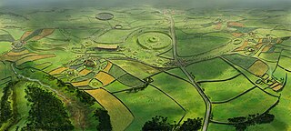
The Thornborough Henges are an ancient monument complex that includes the three aligned henges that give the site its name. They are located on a raised plateau above the River Ure near the village of Thornborough in North Yorkshire, England. The site includes many large ancient structures including a cursus, henges, burial grounds and settlements.

Bryn Celli Ddu is a prehistoric site on the Welsh island of Anglesey located near Llanddaniel Fab. Its name means 'the mound in the dark grove'. It was archaeologically excavated between 1928 and 1929. Visitors can get inside the mound through a stone passage to the burial chamber, and it is the centrepiece of a major Neolithic Scheduled Monument in the care of Cadw. The presence of a mysterious pillar within the burial chamber, the reproduction of the 'Pattern Stone', carved with sinuous serpentine designs, and the fact that the site was once a henge with a stone circle, and may have been used to plot the date of the summer solstice have all attracted much interest.

Archaeology and geology continue to reveal the secrets of prehistoric Scotland, uncovering a complex past before the Romans brought Scotland into the scope of recorded history. Successive human cultures tended to be spread across Europe or further afield, but focusing on this particular geographical area sheds light on the origin of the widespread remains and monuments in Scotland, and on the background to the history of Scotland.

The Standing Stones of Stenness is a Neolithic monument five miles northeast of Stromness on the mainland of Orkney, Scotland. This may be the oldest henge site in the British Isles. Various traditions associated with the stones survived into the modern era and they form part of the Heart of Neolithic Orkney World Heritage Site. They are looked after by Historic Environment Scotland as a scheduled monument.

Long Meg and Her Daughters is a Neolithic stone circle situated north-east of Penrith near Little Salkeld in Cumbria, North West England. One of around 1,300 stone circles in the British Isles and Brittany, it was constructed as a part of a megalithic tradition that emerged during Neolithic, and continued into the Early Bronze Age.

Bedd Arthur is a possibly Neolithic hengiform monument megalithic site in the Preseli Hills in the Welsh county of Pembrokeshire. Thirteen upright stones and at least 2 fallen ones, each around 0.6 metres (2.0 ft) high form an oval horseshoe with similarities to the earliest form of Stonehenge.

Brú na Bóinne, also called the Boyne Valley tombs, is an ancient monument complex and ritual landscape in County Meath, Ireland, located in a bend of the River Boyne. It is one of the world's most important Neolithic landscapes, comprising at least ninety monuments including passage tombs, burial mounds, standing stones and enclosures. The site is dominated by the passage tombs of Newgrange, Knowth and Dowth, built during the 32nd century BC. Together these have the largest assemblage of megalithic art in Europe. The associated archaeological culture is called the "Boyne culture".

Doll Tor is a stone circle just west of Stanton Moor, near the village of Birchover, Derbyshire in the English East Midlands. Doll Tor is part of a tradition of stone circle construction that spread throughout much of Britain, Ireland, and Brittany during the Late Neolithic and Early Bronze Ages, over a period between 3300 and 900 BCE. The purpose of such monuments is unknown, although archaeologists speculate that the stones represented supernatural entities for the circles' builders.

Priddy Circles are a linear arrangement of four circular earthwork enclosures near the village of Priddy on the Mendip Hills in Somerset, England. The circles have been listed as Scheduled Ancient Monuments, and described as 'probable Neolithic ritual or ceremonial monuments similar to a henge'.
A cairn is a man-made pile of stones.

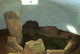
Blackhammer Chambered Cairn is a Neolithic chambered cairn located on the island of Rousay, in Orkney, Scotland. The tomb, constructed around 3000 BC, is a Orkney–Cromarty chambered cairn, characterized by stalled burial compartments. Historic Environment Scotland established the site as a scheduled monument in 1994.
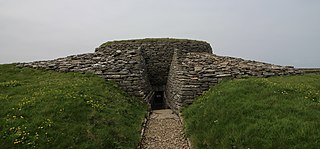
Quoyness chambered cairn is a Neolithic burial monument located on the island of Sanday in Orkney, Scotland. Similar to Maeshowe in design, the tomb was probably built around 3000 BC. The skeletal remains of several people were uncovered in the tomb during excavation in 1867. The monument was partially restored and reconstructed after a second excavation during the early 1950s, to display the different original stages of construction of the tomb. The property is now in the care of Historic Environment Scotland as a scheduled monument.

The stone circles in the British Isles and Brittany are a megalithic tradition of monuments consisting of standing stones arranged in rings. These were constructed from 3200 to 2000 BCE in Great Britain, Ireland and Brittany. It has been estimated that around 4,000 of these monuments were originally constructed in this part of north-western Europe during this period. Around 1,300 of them are recorded, the others having been destroyed.

Knowe of Yarso chambered cairn is a Neolithic burial monument located on the island of Rousay in Orkney, Scotland. The site was excavated in the 1930s, and uncovered human and animal bones as well as pottery sherds, flint and bone tools, and arrowheads. The tomb, dating to the period between 3500 and 2500 BC, is a stalled chambered cairn, similar to Midhowe and Blackhammer. Historic Environment Scotland established the site as a scheduled monument in 1994.