
Min County or Minxian is administratively under the control of the prefecture-level city of Dingxi, in the south of Gansu province, China. In ancient times, it was known as Lintao County due to its location along the Tao River. It was founded as Minzhou (岷州) in 544, named after the Min Mountains in the south of the county. The county received its present name in 1913. In 1985 it became subordinate to Dingxi. Min county is well known by Angelica sinensis which is a Chinese traditional medicine.

Santai County is a county under the administration of the prefecture-level city of Mianyang, in the northeast of Sichuan Province of China. It has an area of 2,660.58 km2 (1,027.26 sq mi). According to the 2020 census, its population stands at 955,800.

Fufeng County is a county under the administration of the prefecture-level city of Baoji, in the west-central part of Shaanxi Province, China. The county lies in the fertile Guanzhong Plain on the north bank of the Wei River between Xi'an, 110 km (68 mi) to the east, and Baoji, 95 km (59 mi) to the west. It has a land area of 751 km2 (290 sq mi), and a population of 450,000 as of 2021.

Yiliang County is a county in the southeast of Yunnan Province, China, bordering the provinces of Sichuan to the northeast and Guizhou to the south. It is under the administration of the prefecture-level city of Zhaotong. In 2020 the population was 631,538 including 14.27% ethnic minorities, most of them Miao (59,920) and Yi (28,406).

Wushan County is a county in the east of Gansu Province of China. It is under the administration of the prefecture-level city of Tianshui. Its postal code is 741300, and in 1999 its population was 418,648 people. The population in 2017 was 500,000 people.
Zhenyuan County is a county in the east of Gansu province, China, bordering Ningxia to the west. It is under the administration of the prefecture-level city of Qingyang. Its postal code is 744500, and its population in 2018 was 528,076 people.
Zhang County or Zhangxian is a county in Gansu province, China. It is under the administration of the prefecture-level city of Dingxi. Its postal code is 748300, and its population in 2017 was 198,200 people.

Mei County or Meixian is a county under the jurisdiction of the prefecture-level city of Baoji, in the west of Shaanxi province, China. It is one of the birthplaces of the Western Zhou culture, during which it was known as Taiguo (邰国). In 794 BC Duke Zhuang of Qin established a town known as Yiyi at its location. During the Eastern Han dynasty it became known as Yinwu. In 2003, 27 Zhou culture bronze ding vessels an other bronzeware were found in Lijia village of Mei County.

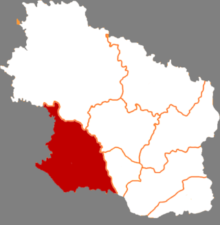
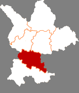
Liuba County is a county under the administration of Hanzhong City, in the southwest of Shaanxi province, China. It is the northernmost county-level division of Hanzhong.

Foping is a county under the administration and in the northeast corner of Hanzhong City, in the south of Shaanxi province, China.

Xunyi is a county in the central part of Shaanxi province, China, bordering Gansu province to the north and northwest. It is the northernmost county-level division of Xianyang City. The county is noted for its apple orchards producing the "Malan Red", a variety of red Fuji apple named after the Malan Red Army site. Besides apples, the economy relies on coal and petroleum exploitation.

Long County or Longxian is a county of Baoji, in the west of Shaanxi province, China, bordering Gansu province to the north and west.

Feng County or Fengxian is a county under the administration of Baoji City, in the west of Shaanxi province, China, bordering Gansu province to the west. There are museums, including a new one about Gung Ho

Zhenping County is a county in the south of Shaanxi province, China, and is the southernmost county-level division of the province. It is under the administration of the prefecture-level city of Ankang. In 2020 it had a population of 58,651.

Baihe County is located in the southeastern portion of Shaanxi province, China and is the easternmost county-level division under the jurisdiction of the prefecture-level city of Ankang. It is by the eastern part of the Daba Mountains and approaches the Han River on the north. On the east it borders Yun County (Hubei), on the south Zhushan County (Hubei), on the west Xunyang County, and is separated from Yunxi County (Hubei) by the Han River. As of November 2020 the population was 162,774.

Wengyuan is a county in the north of Guangdong Province, China, bordering Jiangxi to the northeast. It is under the administration of Shaoguan City. It has a population of 421,756 in 2019, 99.55% of whom speak Hakka. Yao languages are spoken in some parts of the county. 0.616% of the population belongs to minority ethnic groups, most of them Yao.
Teng County or Tengxian is a county of eastern Guangxi, China. It is under the administration of the prefecture-level city of Wuzhou. As of 2021, it had a population of 1,125,264 residing in an area of 3,945.62 km2 (1,523.41 sq mi). The county is divided into a northern and southern part by the Xun River.
Lingyun County is a county in the northwest of Guangxi, China. It is under the administration of Baise city.
Shibing County is a county in the east of Guizhou province, China. It is under the administration of the Qiandongnan Miao and Dong Autonomous Prefecture.

Qinglong County is a county in the southwest of Guizhou province, China. It is under the administration of the Qianxinan Buyei and Miao Autonomous Prefecture. It has a population of 234,162 as of 2020, 56% belonging to ethnic minorities. Qinglong is named after the Qinglong mountain, before 1941 it was called Annang County (安南县). The county was a frontline of the 1854–1873 Miao Rebellions.

