Wenchuan County 汶川县 ཝུན་ཁྲོན་རྫོང་། Kvusa | |
---|---|
Coordinates: 31°28′37″N103°35′24″E / 31.477°N 103.590°E | |
Country | China |
Province | Sichuan |
Autonomous prefecture | Ngawa |
County seat | Weizhou |
Area | |
• Total | 4,804 km2 (1,855 sq mi) |
Population (2020) [1] | |
• Total | 82,971 |
• Density | 17/km2 (45/sq mi) |
• Major nationalities | Qiang - 39.5% Han - 38.7% Tibetan - 20.4% Hui - 1.1% Others - 0.3% |
Time zone | UTC+8 (China Standard) |
Postal code | 623000 |
Area code | 0837 |
Website | www |
Wenchuan County | |||||||
---|---|---|---|---|---|---|---|
Chinese name | |||||||
Chinese | 汶川 | ||||||
| |||||||
Tibetan name | |||||||
Tibetan | ཝུན་ཁྲོན། | ||||||
| |||||||
Qiang name | |||||||
Qiang | Kvusa |
Wenchuan County is a county in Ngawa Tibetan and Qiang Autonomous Prefecture,Sichuan,China.
The county has an area of 4,084 square kilometres (1,577 sq mi), [5] and a population of 100,771 as of 2010. [6]
Wolong National Nature Reserve is a protected area located in Wenchuan County,which houses more than 150 highly endangered giant pandas. The Wolong Special Administrative Region is also located here.
The county was the site of the epicentre and one of the areas most severely hit by the 2008 Sichuan earthquake,also known as the Wenchuan earthquake. [7]
The county is named after the Wenshui River (Chinese :汶水),now known as the Min River. [5]
Wenchuan County was established in 1958,when the former Maowen Qiang Autonomous County (Chinese :茂汶羌族自治县; pinyin :Màowèn Qiāng ZúZìzhìXiàn) was split into Mao County and Wenchuan County. [6]
A number of Neolithic sites have been excavated in the Wenchuan area. The site of Jiangweicheng,located at the northern end of the county town of Weizhou in Wenchuan,has been archaeologically confirmed as a Neolithic site in the upper reaches of the Minjiang River,which extends over a long period divided into three phases. It is estimated to be a new cultural type resulting from the introduction of a late Yangshao culture from the upper and middle reaches of the Yellow River into the upper reaches of the Min River. There are similarities between the sarcophagus burial tomb and the Majiayao culture of Gansu and Qinghai. [8] The site of Jiangwei City is in a different spectrum from the painted pottery and jars excavated from sites in the Chengdu Plain,but lace-mouthed yansha jars of the same spectrum have also been excavated. [9]
On 25 August 1933,a massive 7.5 magnitude earthquake struck the town of Fuxi in Mao County,north of Wenchuan,where six people were killed by a rock collapse and more than 480 people were killed in Wenchuan in the subsequent floods after the earthquake [10]
On May 12, 2008, an earthquake with moment magnitude 7.9 hit the Sichuan Province, with epicentre located in the town of Yingxiu, in Wenchuan county. The county was therefore one of the areas most severely affected by the earthquake. In Chinese, the earthquake is named after the county (the Wenchuan earthquake, 汶川地震), which made its name resonate across the nation. In the county, 15,941 people died, 34,583 were injured, and 7,474 were still missing as of June 6, 2008. [11] [12] The seismic intensity was the highest, reaching level XI in the China Seismic Intensity Scale. [13] After the earthquake, the central government enforced stricter requirements for seismic design in this area. [14] The earthquake also caused many landslides, some of which remained active for years and generated destructive debris flows during the summer rainstorms, which increased the death toll and slowed reconstruction and recovery of the communities in the county. [7] [15]
Wenchuan County administers nine towns: [16]
Name | Simplified Chinese | Hanyu Pinyin | Tibetan | Wylie | Qiang | Administrative division code | |
---|---|---|---|---|---|---|---|
Towns | |||||||
Weizhou Town | 威州镇 | Wēizhōu Zhèn | ཝེ་ཀྲོའུ་གྲོང་རྡལ། | we krovu grong rdal | 513221100 | ||
Yingxiu Town | 映秀镇 | Yìngxiù Zhèn | དབྱིངས་ཤིའུ་གྲོང་རྡལ། | dbyings shivu grong rdal | 513221102 | ||
Wolong Town | 卧龙镇 | Wòlóng Zhèn | ཨོ་ལུང་གྲོང་རྡལ། | o lung grong rdal | Vvolong | 513221103 | |
Shuimo Town | 水磨镇 | Shuǐmó Zhèn | ཧྲུའི་མའོ་གྲོང་རྡལ། | hruvi mavo grong rdal | 513221105 | ||
Xuankou Town | 漩口镇 | Xuánkǒu Zhèn | ཞོན་ཁོའུ་གྲོང་རྡལ། | zhon khovu grong rdal | 513221106 | ||
Sanjiang Town | 三江镇 | Sānjiāng Zhèn | སན་ཅང་གྲོང་རྡལ། | san cang grong rdal | 513221107 | ||
Gengda Town | 耿达镇 | Gěngdá Zhèn | ཀུན་ཏ་གྲོང་རྡལ། | kun ta grong rdal | 513221108 | ||
Miansi Town | 绵虒镇 | Miánsī Zhèn | མེན་ཁྲི་གྲོང་རྡལ། | men khri grong rdal | 513221109 | ||
Bazhou Town | 灞州镇 | Bàzhōu Zhèn | བཱ་ཀྲོའུ་གྲོང་རྡལ | bā krovu grong rdal | 513221111 | ||
Year | Pop. | ±% p.a. |
---|---|---|
1990 | 96,054 | — |
1996 | 104,000 | +1.33% |
2000 | 111,935 | +1.86% |
2005 | 106,238 | −1.04% |
2010 | 100,771 | −1.05% |
According to a 2021 publication by the county government, Wenchuan County's ethnic composition is 39.5% Qiang, 38.7% Han, 20.4% Tibetan, 1.1% Hui, and 0.3% belonging to other ethnic minorities. [5]
The 2010 Chinese Census reported the county's population as 100,771 people. [6]
In 2005, the county reported a population of 106,238, with 34.16% of the population being ethnically Qiang. [17]
The 2000 Chinese Census reported the county's population as 111,935. [6]
In 1996, the county's population was estimated to be about 104,000, up from the 96,054 reported in 1990. [6]
As of 2019, Wenchuan County's gross domestic product totaled ¥7.264 billion, a 6.2% increase from the previous year. [5] Consumer retail sales totaled ¥1.082 billion. [5] The annual per capita disposable income of the county reached ¥34,513 for its urban residents, and ¥15,049 for its rural residents, an increase of 8.2% and 12.0%, respectively. [5]
According to the county government, there were 4,440 people in the county living in poverty in 2014. [5] The county government claims that all its citizens were lifted out of poverty in 2019. [5]
Wenchuan County is home to the Wolong National Nature Reserve, as well as the Sichuan Caopo Nature Reserve (Chinese :四川草坡自然保护区). [5] Other tourist attractions in the county include the AAAAA-rated Wenchuan Special Tourist Area (Chinese :汶川特别旅游区) and the AAAA-rated Yu the Great Cultural Tourist Area (Chinese :大禹文化旅游区). [5]
In 2019, the county received 6,277,800 visitors, bringing the county ¥2.87 billion in revenue. [5]
Road traffic in Wenchuan County is dominated by National Highway 213 and National Highway 317. In 2012, the 82 km long G4217 Duwen Expressway, which connects the city of Dujiangyan and leads to cities in the Sichuan basin, was fully opened to traffic, and the Wenchuan-Markang motorway, the Wenma Expressway, was fully opened to traffic on 31 December 2021. [18] Wenchuan County Bus Station is located in Weizhou Town, Wenchuan, with daily buses to Chengdu, Dujiangyan, Peng County, Li County, Markang, Jiuzhaigou and other places. All scenic spots can be reached by bus, except for Qipanggou Forest Park and Xiqiang Grand Canyon, which are not yet open to traffic. [19] In 2013, bus lines covering 11 towns and townships in the county, including Yingxiu, Xuankou, Shuimo and Sanjiang, were put into operation. [20] By the end of 2014, the total mileage of roads in Wenchuan County was 696 kilometers, 619 kilometers of high-grade highways and 51 kilometers of expressways.
Climate data for Wenchuan (1991–2020 normals, extremes 1981–2010) | |||||||||||||
---|---|---|---|---|---|---|---|---|---|---|---|---|---|
Month | Jan | Feb | Mar | Apr | May | Jun | Jul | Aug | Sep | Oct | Nov | Dec | Year |
Record high °C (°F) | 16.9 (62.4) | 23.6 (74.5) | 32.7 (90.9) | 32.7 (90.9) | 33.9 (93.0) | 35.1 (95.2) | 37.1 (98.8) | 35.5 (95.9) | 34.4 (93.9) | 27.9 (82.2) | 24.2 (75.6) | 22.0 (71.6) | 37.1 (98.8) |
Mean daily maximum °C (°F) | 8.9 (48.0) | 11.8 (53.2) | 16.4 (61.5) | 21.7 (71.1) | 24.6 (76.3) | 26.8 (80.2) | 29.2 (84.6) | 29.1 (84.4) | 24.6 (76.3) | 19.7 (67.5) | 15.5 (59.9) | 10.4 (50.7) | 19.9 (67.8) |
Daily mean °C (°F) | 4.0 (39.2) | 6.4 (43.5) | 10.5 (50.9) | 15.3 (59.5) | 18.6 (65.5) | 21.1 (70.0) | 23.4 (74.1) | 23.3 (73.9) | 19.6 (67.3) | 15.0 (59.0) | 10.5 (50.9) | 5.4 (41.7) | 14.4 (58.0) |
Mean daily minimum °C (°F) | 0.6 (33.1) | 2.9 (37.2) | 6.7 (44.1) | 11.1 (52.0) | 14.4 (57.9) | 17.1 (62.8) | 19.3 (66.7) | 19.3 (66.7) | 16.4 (61.5) | 12.0 (53.6) | 7.1 (44.8) | 2.0 (35.6) | 10.7 (51.3) |
Record low °C (°F) | −7.0 (19.4) | −6.4 (20.5) | −4.4 (24.1) | 2.5 (36.5) | 6.6 (43.9) | 10.5 (50.9) | 13.4 (56.1) | 12.6 (54.7) | 9.3 (48.7) | 3.2 (37.8) | −1.4 (29.5) | −7.4 (18.7) | −7.4 (18.7) |
Average precipitation mm (inches) | 2.6 (0.10) | 6.1 (0.24) | 20.9 (0.82) | 52.5 (2.07) | 70.5 (2.78) | 83.1 (3.27) | 72.6 (2.86) | 78.9 (3.11) | 60.4 (2.38) | 43.1 (1.70) | 10.0 (0.39) | 1.6 (0.06) | 502.3 (19.78) |
Average precipitation days (≥ 0.1 mm) | 4.6 | 6.2 | 11.3 | 16.2 | 18.2 | 18.6 | 16.6 | 14.9 | 15.5 | 15.4 | 6.6 | 2.2 | 146.3 |
Average snowy days | 7.6 | 4.2 | 0.7 | 0.1 | 0 | 0 | 0 | 0 | 0 | 0 | 0.2 | 2.2 | 15 |
Average relative humidity (%) | 62 | 62 | 62 | 63 | 64 | 68 | 69 | 68 | 71 | 72 | 67 | 63 | 66 |
Mean monthly sunshine hours | 121.1 | 112.3 | 130.7 | 148.8 | 138.4 | 109.8 | 135.5 | 140.4 | 98.4 | 93.5 | 112.3 | 118.7 | 1,459.9 |
Percent possible sunshine | 38 | 36 | 35 | 38 | 32 | 26 | 32 | 35 | 27 | 27 | 36 | 38 | 33 |
Source: China Meteorological Administration [21] [22] |
Ngawa Tibetan and Qiang Autonomous Prefecture, also known as Aba, is an autonomous prefecture of northwestern Sichuan, bordering Gansu to the north and northeast and Qinghai to the northwest. Its seat is in Barkam, and it has an area of 83,201 km2 (32,124 sq mi). The population was 895,200 by 2022.
Pengzhou, formerly Peng County or Pengxian, is a county-level city of Sichuan Province, Southwest China, it is under the administration of the prefecture-level city of Chengdu. There is an expressway that connects Pengzhou to Chengdu. It is bordered by the prefecture-level divisions of Deyang to the northeast and the Ngawa Tibetan and Qiang Autonomous Prefecture to the north.
Gertse County, Gêrzê County or Gaize County is a county located in Ngari Prefecture in the northwest of the Tibet Autonomous Region, China, bordering Xinjiang to the north.
Beichuan Qiang Autonomous County is a county under the jurisdiction of Mianyang City in northern Sichuan province, China. It is located in an ethnically diverse mountainous region of Sichuan. Its Chinese name literally means "North" (bei) "River" (chuan). Its new county seat is located at Yongchang after the 2008 Sichuan earthquake.
Yingxiu is a town of southern Wenchuan County, in central Sichuan Province. It is located at the southern end of the Ngawa Tibetan and Qiang Autonomous Prefecture, and lies on the road to Jiuzhaigou Valley, Wolong and the Siguniang Mountains. It is located 47 kilometres (29 mi) south of the county urban centre, and just 14 kilometres (8.7 mi) west of the city of Dujiangyan.
Xuankou is a town located in Wenchuan County, Ngawa, Sichuan, China. The population is approximately 12,000, and is distributed roughly half urban and half rural. As of 2018, it has one residential community and 16 villages under its administration. The total area of the jurisdiction is 39.64 km (24.63 mi).
Li County or Lixian, formerly known as Lifan (理番), is a county in Ngawa Tibetan and Qiang Autonomous Prefecture, Sichuan, China. China National Highway G317 and the Zhaxiling River run through the whole territory.
Mao County or Maoxian is a county in Ngawa Prefecture, Sichuan Province, China.
Zoigê County or Ruo'ergai County is a county of Ngawa Tibetan and Qiang Autonomous Prefecture in Sichuan, China, bordering Gansu to the north. It is the northernmost county of the province. It is part of the Tibetan traditional region of Amdo.
An earthquake occurred in the province of Sichuan, China at 14:28:01 China Standard Time on May 12, 2008. Measuring at 8.0 Ms, the earthquake's epicenter was located 80 kilometres (50 mi) west-northwest of Chengdu, the provincial capital, with a focal depth of 19 km (12 mi). The earthquake ruptured the fault for over 240 km (150 mi), with surface displacements of several meters. The earthquake was also felt as far away as both Beijing and Shanghai—1,500 and 1,700 km away, respectively—where office buildings swayed with the tremor, as well as Bangkok, Thailand and Hanoi, Vietnam. Strong aftershocks, some exceeding 6 Ms, continued to hit the area up to several months after the main shock, causing further casualties and damage. The earthquake also caused the largest number of geohazards ever recorded, including about 200,000 landslides and more than 800 quake lakes distributed over an area of 110,000 km2 (42,000 sq mi).
After the May 12, 2008 earthquake in the Chinese province of Sichuan, there were a series of allegations of corruption against officials involved in the construction of schools in regions affected by the quake. It gained momentum in May and June 2008, and the allegations culminated in protests from grieving parents of children who died in the earthquake as a result of the collapse of various schools in the quake zone.
The 2008 Panzhihua earthquake struck southern Sichuan province, China on August 30 at 16:30:50.5 China Standard Time with a surface wave magnitude of 6.1, or 6.0 Mw. It is also cited as the Renhe-Huili earthquake, especially in SCEA reports and early CEA reports. It was not an aftershock of the Sichuan earthquake that occurred several months prior. With more than 400 aftershocks, it caused over 40 deaths, the collapse of 10,000 homes and damage to other infrastructure in the provinces of Sichuan and Yunnan. The maximum liedu was VIII.
The China seismic intensity scale (CSIS) is a national standard in the People's Republic of China used to measure seismic intensity. Similar to EMS-92 on which CSIS drew reference, seismic impacts are classified into 12 degrees of intensity, or liedu in Roman numerals from I for insensible to XII for landscape reshaping.
Jinchuan County or Quqên is a county in the northwest of Sichuan Province, China. It is under the administration of the Ngawa Tibetan and Qiang Autonomous Prefecture. The seat of county is Dowu Town (Lewu).
Heishui County is a county in the north of Sichuan Province, China. It is under the administration of the Ngawa Tibetan and Qiang Autonomous Prefecture. The county has an area of 1,682 square miles (4,356 km2) and its average elevation is 11,627 feet (3,544 m). As of 2016, the county has a population of 61,744.
The 2014 Kangding earthquake struck Kangding County, Garzê Tibetan Autonomous Prefecture, Sichuan, China, with a moment magnitude of 5.9 on 22 November. The earthquake killed five and injured 54 people.
The 2017 Jiuzhaigou earthquake occurred on 8 August 2017, in Zhangzha Town, Jiuzhaigou County, Ngawa Prefecture, Sichuan Province, China. The earthquake was registered at Ms 7.0 and killed at least 25 people in the mountainous region of northern Sichuan.
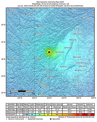
On June 1, 2022, a moment magnitude (Mw ) 5.8 or surface-wave magnitude (Ms ) 6.1 earthquake struck Lushan County in Ya'an, Sichuan Province, China. At least four people were killed and 42 were injured. The earthquake had a maximum intensity of VIII on the China seismic intensity scale, causing damage to many homes and triggering rockslides.
A Mw 6.7 earthquake struck Luding County in Sichuan province, China on 5 September 2022 at 12:52:19 local time. The epicenter was located 226 km (140 mi) from Chengdu, or 43 km (27 mi) southeast of Kangding. Ninety-three people died, 424 were injured and 24 remained missing. More than 13,000 homes and other infrastructure were damaged or destroyed. It was the largest earthquake to strike the province since 2017.
The 2019 Zigong earthquake occurred in Zigong, Sichuan Province, China, at about 13:00 on February 25, 2019. The epicentre was located in Rongxian County, with a magnitude of Ms 4.9, a focal depth of about 5 km and a maximum intensity of VI. The earthquake killed two people and injured 12 others.
2 汶川(Wèn- chuān),地名,在四川。
汶 wèn{...}2 用于地名。如汶川,在四川。
{{cite journal}}
: Cite journal requires |journal=
(help)CS1 maint: multiple names: authors list (link)