
The Canyon Lands Section of the Colorado Plateau is a physiographic section of the larger Colorado Plateaus province, which in turn is part of the larger Intermontane Plateaus physiographic division in the Western United States [1]
The Canyon Lands Section of the Colorado Plateau is a physiographic section of the larger Colorado Plateaus province, which in turn is part of the larger Intermontane Plateaus physiographic division in the Western United States [1]
The Canyon Lands are a desolate, but spectacularly scenic sandstone area of southeastern Utah and northeastern Arizona. Dominated by canyons (as the name implies) this section has four large upwarps between which are structural basins. Very little faulting is associated with the upwarps or basins. Other distinctive features of the Canyon Lands Section are the laccolithic mountains, like the Henry Mountains and the La Sal Mountains. These are structural domes.
The turbid San Juan River flows into the region from the east, through a deep meandering gorge, which, with its tributaries, drains a far-reaching area, including the La Plata Mountains, the San Juan Mountains and other lesser ranges on the Continental Divide, the Chuska Mountains, and enormous areas of mesa land in the interior of the basin. From the Wasatch Range and Aquarius Mountains on the west come other, but lesser, silt-laden streams, all carving the deep, winding canyons which have given this country its name and developed a weirdly dissected landscape. The Colorado River is the largest such stream.
In northeastern Arizona is Monument Valley, where sharp spires, obelisks, and tower-like masses of rock rise hundreds of feet above their surroundings. At the eastern margin of the Canyon Lands is the Mesa Verde, a huge cuesta that has been deeply dissected by streams. Here in great recesses in the canyon walls are found the ruins of ancient cliff dwellings.
East of the Little Colorado River are the brilliantly colored areas known as the Painted Desert. Here the rocks show gorgeous colors in strata that are gently inclined and present a series of cliffs that are slowly migrating as weathering and erosion proceed.
The area north of the canyon of the San Juan River has several surfaces varying from 6,000–7,000 ft (1,800–2,100 m) above sea level. There are bold escarpments bordering some of these plateaus, canyons with steep walls, and a group of mesas called the Tables of the Sun, and several national monuments containing natural bridges.
The Canyon Lands terminate, approximately, at a third, intermittent barrier formed by the Paria Plateau, Black Mesa, and the Chuska Mountains mass.
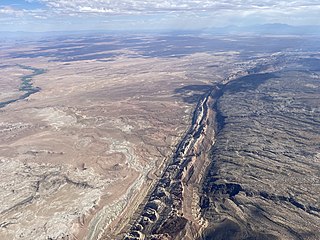
Perhaps the dominant physical feature within the area is the San Rafael Swell occupying the majority of Emery County, Utah.[ according to whom? ] This feature is a large northeast trending upwarp approximately 75 miles (121 km) long and 30 miles (48 km) wide that is part of a much larger, double-plunging anticline (e.g., dome) structure. This large, regional fold exposes rocks of Pennsylvanian through Cretaceous age. Resistant beds of sandstone are exposed as hogbacks on the steeply upturned east and west flanks of the anticline and are referred to locally as "reefs." Three perennial rivers (the Muddy, San Rafael, and Price) flow eastward across the San Rafael Swell into the Green and Colorado River systems. [2]

The Intermontane Plateaus of the Western United States is one of eight U.S. Physiographic regions (divisions) of the physical geography of the contiguous United States. The region is composed of intermontane plateaus and mountain ranges. It is subdivided into physiographic provinces, which are each subdivided into physiographic sections.

The Entrada Sandstone is a formation in the San Rafael Group found in the U.S. states of Wyoming, Colorado, northwest New Mexico, northeast Arizona, and southeast Utah. Part of the Colorado Plateau, this formation was deposited during the Jurassic Period sometime between 180 and 140 million years ago in various environments, including tidal mudflats, beaches, and sand dunes. The Middle Jurassic San Rafael Group was dominantly deposited as ergs in a desert environment around the shallow Sundance Sea.

The San Juan River is a major tributary of the Colorado River in the Southwestern United States, providing the chief drainage for the Four Corners region of Colorado, New Mexico, Utah, and Arizona. Originating as snowmelt in the San Juan Mountains of Colorado, it flows 383 miles (616 km) through the deserts of northern New Mexico and southeastern Utah to join the Colorado River at Glen Canyon.

The Colorado Plateau, also known as the Colorado Plateau Province, is a physiographic and desert region of the Intermontane Plateaus, roughly centered on the Four Corners region of the southwestern United States. This province covers an area of 336,700 km2 (130,000 mi2) within western Colorado, northwestern New Mexico, southern and eastern Utah, northern Arizona, and a tiny fraction in the extreme southeast of Nevada. About 90% of the area is drained by the Colorado River and its main tributaries: the Green, San Juan, and Little Colorado. Most of the remainder of the plateau is drained by the Rio Grande and its tributaries.

The San Rafael River is a tributary of the Green River, approximately 90 miles (140 km) long, in east central Utah, United States. The river flows across a sparsely populated arid region of the Colorado Plateau, and is known for the isolated, scenic gorge through which it flows.
The San Rafael Swell is a large geologic feature located in south-central Utah, United States about 16 miles (26 km) west of Green River. The San Rafael Swell, measuring approximately 75 by 40 miles, consists of a giant dome-shaped anticline of sandstone, shale, and limestone that was pushed up during the Paleocene Laramide Orogeny 60–40 million years ago. Since that time, infrequent but powerful flash floods have eroded the sedimentary rocks into numerous valleys, canyons, gorges, mesas, buttes, and badlands.

The Cutler Formation or Cutler Group is a rock unit that is exposed across the U.S. states of Arizona, northwest New Mexico, southeast Utah and southwest Colorado. It was laid down in the Early Permian during the Wolfcampian epoch.

The Moenkopi Formation is a geological formation that is spread across the U.S. states of New Mexico, northern Arizona, Nevada, southeastern California, eastern Utah and western Colorado. This unit is considered to be a group in Arizona. Part of the Colorado Plateau and Basin and Range, this red sandstone was laid down in the Lower Triassic and possibly part of the Middle Triassic, around 240 million years ago.

The Chinle Formation is an Upper Triassic continental geological formation of fluvial, lacustrine, and palustrine to eolian deposits spread across the U.S. states of Nevada, Utah, northern Arizona, western New Mexico, and western Colorado. The Chinle is controversially considered to be synonymous to the Dockum Group of eastern Colorado and New Mexico, western Texas, the Oklahoma panhandle, and southwestern Kansas. The Chinle is sometimes colloquially named as a formation within the Dockum Group in New Mexico and in Texas. The Chinle Formation is part of the Colorado Plateau, Basin and Range, and the southern section of the Interior Plains.

The Glen Canyon Group is a geologic group of formations that is spread across the U.S. states of Nevada, Utah, northern Arizona, north west New Mexico and western Colorado. It is called the Glen Canyon Sandstone in the Green River Basin of Colorado and Utah.
The San Rafael Group is a geologic group or collection of related rock formations that is spread across the U.S. states of New Mexico, Arizona, Utah and Colorado. As part of the Colorado Plateau, this group of formations was laid down in the Middle Jurassic during the Bajocian, Bathonian and Callovian Stages.

The Carmel Formation is a geologic formation in the San Rafael Group that is spread across the U.S. states of Wyoming, Utah, Colorado, north east Arizona and New Mexico. Part of the Colorado Plateau, this formation was laid down in the Middle Jurassic during the late Bajocian, through the Bathonian and into the early Callovian stages.

The Chuska Mountains are an elongate range on the southwest Colorado Plateau and within the Navajo Nation whose highest elevations approach 10,000 feet. The range is about 80 by 15 km. It trends north-northwest and is crossed by the state line between Arizona and New Mexico. The highlands are a dissected plateau, with an average elevation of about 2,740 m (8,990 ft), and subdued topography. The highest point is Roof Butte at 2,994 m (9,823 ft), near the northern end of the range in Arizona. Other high points include the satellite Beautiful Mountain at 2,861 m (9,386 ft) and Lukachukai Mountains at 2,885 m (9,465 ft), both also near the northern end, and Matthews Peak at 2,911 m (9,551 ft). The San Juan Basin borders the Chuskas on the east, and typical elevations in nearby parts of that basin are near 1,800 m (5,900 ft). The eastern escarpment of the mountains is marked by slumps and landslides that extend out onto the western margin of the San Juan Basin. To the north, the Chuskas are separated from the Carrizo Mountains by Red Rock Valley, which is today commonly referred to as Red Valley.

The Uinta Basin is a physiographic section of the larger Colorado Plateaus province, which in turn is part of the larger Intermontane Plateaus physiographic division. It is also a geologic structural basin in eastern Utah, east of the Wasatch Mountains and south of the Uinta Mountains. The Uinta Basin is fed by creeks and rivers flowing south from the Uinta Mountains. Many of the principal rivers flow into the Duchesne River which feeds the Green River—a tributary of the Colorado River. The Uinta Mountains forms the northern border of the Uinta Basin. They contain the highest point in Utah, Kings Peak, with a summit 13,528 feet above sea level. The climate of the Uinta Basin is semi-arid, with occasionally severe winter cold.

The Navajo Section is a physiographic section of the larger Colorado Plateaus Province, which in turn is part of the larger Intermontane Plateaus physiographic Division.
In geology, the Paradox Formation Is a Pennsylvanian age formation which consists of abundant evaporites with lesser interbedded shale, sandstone, and limestone. The evaporites are largely composed of gypsum, anhydrite, and halite. The formation is found mostly in the subsurface, but there are scattered exposures in anticlines in eastern Utah and western Colorado. These surface exposures occur in the Black Mesa, San Juan and Paradox Basins and the formation is found in the subsurface in southwestern Colorado, southeastern Utah, northeastern Arizona and northeastern New Mexico.

The Mountain States form one of the nine geographic divisions of the United States that are officially recognized by the United States Census Bureau. It is a subregion of the Western United States.

The Defiance Plateau, part of the geologic Defiance Uplift, is an approximately 75-mile (121 km) long, mostly north-trending plateau of Apache County, Arizona, with its east and southeast perimeter, as parts of San Juan and McKinley Counties, New Mexico.

The Lower Permian Esplanade Sandstone is a cliff-forming, resistant sandstone, dark red, geologic unit found in the Grand Canyon. The rock unit forms a resistant shelf in the west Grand Canyon, south side of the Colorado River, at the east of the Toroweap Fault, down-dropped to west, southeast of Toroweap Overlook, and west of Havasupai. The red, sandstone shelf, The Esplanade is about 20-mi long. At Toroweap Overlook region, Toroweap Valley with Vulcan's Throne, Uinkaret volcanic field, the resistant Esplanade Sandstone is described in access routes exploring the Toroweap Lake area.

The Shinarump Conglomerate is a geologic formation found in the Four Corners region of the United States. It was deposited in the early part of the Late Triassic period.
| Branches |
| ||||||
|---|---|---|---|---|---|---|---|
| Techniques and tools | |||||||
| Institutions | |||||||
| Education | |||||||
 | ||