
The Windover Archeological Site is a Middle Archaic archaeological site and National Historic Landmark in Brevard County near Titusville, Florida, USA, on the central east coast of the state. Windover is a muck pond where skeletal remains of 168 individuals were found buried in the peat at the bottom of the pond. The skeletons were well preserved because of the characteristics of peat. In addition, remarkably well-preserved brain tissue has been recovered from many skulls from the site. DNA from the brain tissue has been sequenced. The collection of human skeletal remains and artifacts recovered from Windover Pond represent among the largest finds of each type from the Archaic Period. It is considered one of the most important archeological sites ever excavated.

The Wesley Butler Archeological District is a historic district composed of a group of archaeological sites in the southwestern corner of the U.S. state of Ohio. Located south of Elizabethtown, the district comprises three Native American mounds and the site of a Native American village, spread out over an area of 40 acres (16 ha). Although the mounds are built atop part of the village site, they are not contemporaneous: the mounds were built by Woodland peoples, but the village dates from the far older Archaic period.

The Mount Nebo Archaeological District is a historic district in the southwestern corner of the U.S. state of Ohio. Located near North Bend, the district lies near the intersection of Mount Nebo and Brower Roads. Included in the district's 40 acres (16 ha) of area are two contributing properties: one large archaeological site and one Native American mound.

The Shawnee Lookout Archeological District is a historic district in the southwestern corner of the U.S. state of Ohio. Located southwest of Cleves in Hamilton County's Miami Township, the district is composed of forty-six archaeological sites spread out over an area of 2,000 acres (810 ha). Thirty-four of these sites are located in the 1,000-acre (400 ha) Shawnee Lookout Park, which has been called one of the most beautiful parks in southwestern Ohio.

The Eaker Site (3MS105) is an archaeological site on Eaker Air Force Base near Blytheville, Arkansas that was declared a National Historic Landmark in 1996. The site is the largest and most intact Late Mississippian Nodena Phase village site within the Central Mississippi Valley, with archaeological evidence indicating a palisaded village some 50 acres (20 ha) in size, with hundreds of structures. The site's major period of occupation was 1350–1450 CE, although evidence of occupation dates back to 600 CE. The site is also hypothesized to have been occupied by the Quapaw prior to a migration further south, after which they made contact with Europeans in the late 17th century.

Hampson Archeological Museum State Park is a 5-acre (2.0 ha) Arkansas state park in Mississippi County, Arkansas in the United States. The museum contains a collection of archeological artifacts from the Nodena Site, which is a former Native American village on the Mississippi River between 1400 and 1650. James K. Hampson began excavating the site in the 1920s, a museum was built in 1946 and the Arkansas General Assembly officially accepted the collection of artifacts from the Hampson family on March 30, 1957. The park first opened in 1961 as Hampson Museum State Park and has since been renamed.
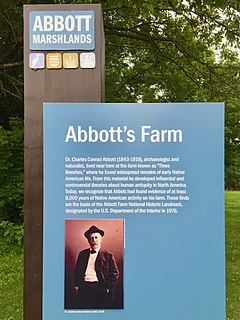
The Abbott Farm Historic District is a National Historic Landmark archaeological site in New Jersey. It is the largest known Middle Woodland village of its type on the East Coast of the United States. Significant evidence suggests that the Delaware River floodplain was occupied by Paleoindian people for a long period. It was inhabited between 500 BC and 500 AD. It has been a source of controversy and debate around early development.

The Cushnoc Archeological Site, also known as Cushnoc or Koussinoc or Coussinoc, is an archaeological site in Augusta, Maine that was the location of a 17th-century trading post operated by English colonists from Plymouth Colony in present-day Massachusetts. The trading post was built in 1628 and lies on the Kennebec River. It is adjacent to Fort Western, an 18th-century stockade fort around which the city of Augusta grew. The site is significant as it provides a window into trading, living, and construction practices in the early period of colonial settlement in New England. It was declared a National Historic Landmark in 1993.

Cedar Swamp Archeological District is a prehistoric and historic archaeologically sensitive area in eastern Westborough, Massachusetts, and extending into the northwest corner of Hopkinton. Cedar Swamp is an area of more than 2,600 acres (1,100 ha) of wetlands that include the headwaters area of the Sudbury River. Archeological surveys of the environmentally sensitive and critical area have identified many Native American sites of interest. It is believed that Native Americans prized wood from the cedar trees that grew in the area. The archeological district, which encompasses much of the Cedar Swamp area, was added to the National Register of Historic Places in 1988.

The Canfield Island Site, also known as Archeological Site 36LY37, is an archaeological site in Lycoming County, Pennsylvania, United States. Located on Canfield Island in the West Branch Susquehanna River, the site lies east of the city of Williamsport in Loyalsock Township. It is believed to have been inhabited by prehistoric Native Americans for thousands of years, with the oldest discoveries dating back to more than one millennium before Christ.

Allen Island or Allen's Island is a 450-acre (180 ha) private island which is part of St. George, Knox County, Maine. it is located near the southeastern end of Muscongus Bay, roughly midway between the southernmost parts of the St. George's mainland, and Monhegan Island.

The Quinebaug River Prehistoric Archeological District encompasses a collection of prehistoric archaeological sites near the Quinebaug River in Canterbury, Connecticut. The district covers 22 acres (8.9 ha), including five sites dating from the Late Archaic to the period of European contact. The district was listed on the National Register of Historic Places in 2009, and was designated a state archaeological preserve in 2003.

The Madison Farm Historic and Archeological District is a complex of historic and prehistoric Native American and colonial sites in rural Montgomery County, Virginia. It is located in and near the flood plains of the South Fork of the Roanoke River, and covers 115 acres (47 ha). Its historic artifacts include a surviving hall-parlor log house, probably built late in the 18th century by William Madison, which is one of the few of its type to survive in the county. The building was substantially modified in the 19th century, refinishing the interior and adding a two-story porch. The farm site includes a number of historic outbuildings, and is a good prospect for archaeological investigation into period farming practices.
The Rumford Archaeological Sites are a collection of prehistoric Native American sites in the vicinity of the Androscoggin River near Rumford, Maine. These six sites provide a window of observation into the movements and practices of Native Americans from c. 7,000 BCE to the Late Woodland period and contact with Europeans. These sites are the subject of three separate listings on the National Register of Historic Places in 1972: the Rumford Falls I-IV Sites, the Rumford V Site, and the Town of Rumford Site. The locations of these sensitive sites are not generally publicized.

Aquadoctan was one of the largest known Native American villages in what is now the U.S. state of New Hampshire. In an area commonly known today as The Weirs, the village lay on the north bank of the Winnipesaukee River at the outlet of Lake Winnipesaukee in the Lakes Region of New Hampshire. The site is now in Weirs Beach, a summer resort and village of the city of Laconia. The Native American village, whose archaeological remains extend for a half mile along the river and a quarter mile along the lake, has been documented through archaeological investigation to have evidence of settlement from 9,000 BCE to the late seventeenth century. Colonial reports document that the site was abandoned substantially in 1696, when most of New Hampshire's remaining native population withdrew to join the Pequawket at present-day Fryeburg, Maine.
The Vail Site is a prehistoric Native American archaeological site in the remote north of Oxford County, Maine. It is located along an ancient course of the Magalloway River in an area that is occasionally under the waters of the man-made Aziscohos Lake. The site was discovered in 1979, and has been the subject of several archaeological excavations since then. The site includes at least eight encampment areas and a significant kill zone where the Native Americans killed a large number of caribou. A 1-acre (0.40 ha) section of the site was listed on the National Register of Historic Places in 1980; this listing was enlarged to 7.5 acres (3.0 ha) in 1984.
The Clarke and Lake Company Archeological Site encompasses all that is left of a historic colonial settlement in Arrowsic, Maine. The site, located on the banks of the Sasanoa River on the northern part of Arrowsic Island, was the local headquarters of the business enterprises operated by Major Thomas Clarke and Captain Thomas Lake. Clarke and Lake were successful merchants and businessmen based in Boston, who at their height claimed more than 450 square miles (120,000 ha) of territory in the Kennebec River watershed, in addition to land holdings and business interests elsewhere. They acquired Arrowsic Island, and established their settlement c. 1654, eventually building a large manor house, warehouse, gristmill and sawmill, and numerous other outbuildings. They developed a small community on the island, with farms and shops, and managed the civic business of the area. Their business included trade with the local Native Americans, fishing, lumbering, and the raising of cattle for shipment to Boston.
The Hodgdon Site, designated the Maine Archeological Survey Site 69.4, is a prehistoric rock art site near Embden, Maine. The site is located on a ledge overlooking the Kennebec River, in territory that was under the control of the Norridgewock tribe around the time of European contact, and is several miles downriver from the historic Norridgewock village. The markings are estimated to date to the Late Ceramic Period, and include anthropomorphic representations of human figures, as well as an unusual representation of a post-and-beam structure topped by parallel semicircular arcs. This latter figure is thought to represent the house of Father Sébastien Rale, a French Jesuit priest who built a house at Norridgewock in 1722.
The Big Black Site is an archaeological site in remote northwestern Aroostook County, Maine. The 1-acre (0.40 ha) site, located near the mouth of the Big Black River exhibits evidence of occupation and use over a period of several thousand years, ending in historic times. The site is significant as a well-preserved site on an undammed river, and was, at the time of its listing on the National Register of Historic Places in 1975, expected to yield significant information about the area's prehistory.

The East Lake Abert Archeological District is an area in Lake County, Oregon, United States, that features numerous prehistoric camp sites and petroglyphs. It is located along the eastern shore of Lake Abert on land administered by the Bureau of Land Management and the Oregon Department of Transportation. The site includes stone-walled house pits and prehistoric rock art made by ancient Native Americans who occupied the site for approximately 11,000 years. Because of its unique archaeological and cultural significance, the East Lake Abert Archaeological District was listed on the National Register of Historic Places in 1978.
