Carlton, New York

Last updated

Carlton, New York
Oak Orchard
Carlton, NY, USA - panoramio (10).jpg
Orleans County New York incorporated and unincorporated areas Carlton highlighted.svg
Location in Orleans County and the state of New York.
New York in United States (US48).svg
Location of New York in the United States
Coordinates: 43°20′21″N78°12′51″W / 43.33917°N 78.21417°W / 43.33917; -78.21417
Country United States
State New York
County Orleans
Area
[1]
  Total44.41 sq mi (115.02 km2)
  Land43.61 sq mi (112.94 km2)
  Water0.80 sq mi (2.07 km2)
Elevation
246 ft (75 m)
Population
 (2010)
  Total2,994
  Estimate 
(2016) [2]
2,905
  Density66.62/sq mi (25.72/km2)
Time zone UTC-5 (Eastern (EST))
  Summer (DST) UTC-4 (EDT)
FIPS code 36-12496
GNIS feature ID0978792

Carlton is a town in Orleans County, New York, United States. The population was 2,994 at the 2010 census. The name is derived from Carleton, a shipbuilding district near Ottawa, Ontario, Canada.

Contents

The Town of Carlton lies in the north part of the county, on the shore of Lake Ontario.

History

The Town of Carlton was formed from the towns of Gaines and Ridgeway in 1822 and was then known as the "Town of Oak Orchard". It was renamed as "Carlton" in 1825.

The population was 2,297 in 1892.

Notable events

On July 27, 1883 Illinois politician Thomas Hoyne died in a railroad accident which took place outside of the hamlet of Carlton Station. He was subsequently buried at Rosehill Cemetery in Chicago. [3]

On September 1, 2010, five teenagers were charged with disrupting religious services at the World Sufi Foundation mosque located in Carlton. The teenagers were accused of discharging a firearm, yelling obscenities, and hitting a mosque attendee with a car. [4]

Point Breeze, a hamlet in Carlton located at the meeting point of Lake Ontario and the Oak Orchard River, was selected in 2013 by the World Fishing Network as the United States' "Ultimate Fishing Town" following an online competition that highlighted the town's sport fishing assets. [5]

Geography

According to the United States Census Bureau, the town has a total area of 44.5 square miles (115 km2), of which 43.7 square miles (113 km2) is land and 0.8 square miles (2.1 km2) (1.86%) is water.

The Oak Orchard River enters Lake Ontario in the north part of Carlton, as does Johnson Creek. The Lake Ontario State Parkway begins in the town and ends in Monroe County, New York. New York State Route 18 is the major east–west route traversing the town, while north-south Routes NY-98 and NY-279 have their northern termini in Carlton.

Demographics

Historical population
CensusPop.Note
1830 1,168
1840 2,27594.8%
1850 2,80923.5%
1860 2,447−12.9%
1870 2,327−4.9%
1880 2,4776.4%
1890 2,374−4.2%
1900 2,338−1.5%
1910 2,259−3.4%
1920 1,832−18.9%
1930 1,699−7.3%
1940 1,540−9.4%
1950 1,77515.3%
1960 2,80057.7%
1970 2,540−9.3%
1980 2,81810.9%
1990 2,808−0.4%
2000 2,9605.4%
2010 2,9941.1%
2016 (est.)2,905 [2] −3.0%
U.S. Decennial Census [6]

As of the census [7] of 2000, there were 2,960 people, 1,103 households, and 793 families residing in the town. The population density was 67.7 inhabitants per square mile (26.1/km2). There were 1,619 housing units at an average density of 37.0 per square mile (14.3/km2). The racial makeup of the town was 94.32% White, 3.24% African American, 0.54% Native American, 0.10% Asian, 0.03% Pacific Islander, 0.91% from other races, and 0.84% from two or more races. Hispanic or Latino of any race were 1.11% of the population.

There were 1,103 households, out of which 34.1% had children under the age of 18 living with them, 58.3% were married couples living together, 8.3% had a female householder with no husband present, and 28.1% were non-families. 21.3% of all households were made up of individuals, and 7.8% had someone living alone who was 65 years of age or older. The average household size was 2.68 and the average family size was 3.11.

In the town, the population was spread out, with 26.9% under the age of 18, 6.0% from 18 to 24, 29.3% from 25 to 44, 26.8% from 45 to 64, and 10.9% who were 65 years of age or older. The median age was 38 years. For every 100 females, there were 110.7 males. For every 100 females age 18 and over, there were 107.8 males.

The median income for a household in the town was $40,660, and the median income for a family was $42,028. Males had a median income of $32,188 versus $23,448 for females. The per capita income for the town was $17,439. About 7.9% of families and 10.3% of the population were below the poverty line, including 17.5% of those under age 18 and 4.8% of those age 65 or over.

Communities and locations in Carlton

The Oak Orchard River at Point Breeze. Oak Orchard River - Point Breeze.jpg
The Oak Orchard River at Point Breeze.
Lake Alice, between Waterport (right) and Waterport Station (left). Oak Orchard River - Lake Alice.jpg
Lake Alice, between Waterport (right) and Waterport Station (left).

Related Research Articles

<span class="mw-page-title-main">Orleans County, New York</span> County in New York, United States

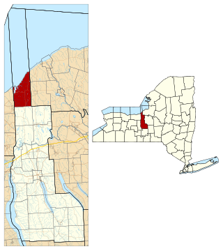
Orleans County is a county in the western part of the U.S. state of New York. As of the 2020 census, the population was 40,343. The county seat is Albion. The county received its name at the insistence of Nehemiah Ingersoll though historians are unsure how the name was selected. The two competing theories are that it was named to honor the French Royal House of Orleans or that it was to honor Andrew Jackson's victory in New Orleans.

<span class="mw-page-title-main">Sterling, New York</span> Town in New York, United States

Sterling is a town in Cayuga County, New York, United States. The population was 3,040 at the 2010 census. Located on the shore of Lake Ontario, the town is named after William Alexander, Lord Stirling, an American general of the Revolutionary War. Sterling is the most northerly town in the county and lies northwest of Syracuse.

<span class="mw-page-title-main">Evans, New York</span> Town in New York, United States

Evans is a town in Erie County, New York, United States. The population was 16,356 at the 2010 census. The town derives its name from David E. Evans, an agent of the Holland Land Company and nephew of land agent Joseph Ellicott.

Hounsfield is a town in Jefferson County, New York, United States. The population was 3,466 at the 2010 census. The name of the town is from Ezra Hounsfield, a land agent and land owner.

<span class="mw-page-title-main">Hamlin, New York</span> Town in New York, United States

Hamlin is a town in Monroe County, New York, United States. The population was 9,045 at the 2010 census.

<span class="mw-page-title-main">Porter, New York</span> Town in New York, United States

Porter is a town in Niagara County, New York, United States. The population was 6,771 at the 2010 census. The town was named after Judge Augustus Porter.

<span class="mw-page-title-main">Spafford, New York</span> Town in New York, United States

Spafford is a town in Onondaga County, New York, United States. As of the 2020 Census, the population was 1,588. The town was named after Horatio Gates Spafford, a writer and founder of the local library. Spafford is in the southwestern corner of Onondaga County and is southwest of Syracuse.

<span class="mw-page-title-main">Gaines, New York</span> Town in New York, United States

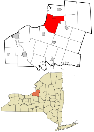
Gaines is a town in Orleans County, New York, United States. The population was 3,378 at the 2010 census. The town is named after General Edmund P. Gaines, who defended the area during the War of 1812.

<span class="mw-page-title-main">Ridgeway, New York</span> Town in New York, United States

Ridgeway is a town in Orleans County, New York, United States. The population was 6,886 at the 2000 census. The name of the town is derived from "Ridge Road," an important highway in the 19th century.

<span class="mw-page-title-main">Richland, New York</span> Town in New York, United States

Richland is a town in Oswego County, New York, United States. The population was 5,718 at the 2010 census.

<span class="mw-page-title-main">Lisbon, New York</span> Town in New York, United States

Lisbon is a town in St. Lawrence County, New York, United States. The population was 4,102 at the 2010 census.

<span class="mw-page-title-main">Ontario, New York</span> Town in Wayne County, New York, US

Ontario is a town in the northwest corner of Wayne County, New York, United States. The population was 9,778 at the 2000 census, and 10,136 at the 2010 census. The town is named after the Great Lake on its northern border.

<span class="mw-page-title-main">Plattsburgh (town), New York</span> Town in New York, United States

Plattsburgh is a town in Clinton County, New York, United States. The population was 11,886 at the 2020 census. The town is named after Zephaniah Platt, an early land owner, and it surrounds the separate and more populous city of the same name. The town is in the eastern part of the county, in the North Country region of the state of New York. The region's airport, Plattsburgh International Airport, is located in the southern part of the town.

Cape Vincent is a town in Jefferson County, New York, United States. The population was 2,777 at the 2010 census.

Ellisburg is an incorporated town in Jefferson County, New York. The population was 3,474 at the time of the 2010 census. The town is in the southwestern corner of the county and is south of Watertown. Ellisburg is named after early European-American landowners. Among the villages in the town is Ellisburg.

Livonia is a town in Livingston County, New York, United States. As of the 2010 census, the town population was 7,809. The town contains a village also named Livonia. The town is on the eastern border of the county.

<span class="mw-page-title-main">Wilson (town), New York</span> Town in New York, United States

Wilson is a town in Niagara County, New York, United States. The population was 5,993 at the 2010 census. The town was named after an early settler, Reuben Wilson, who built and dwelt in a log cabin on the shore of Lake Ontario at the site of what would become the Village of Wilson.

<span class="mw-page-title-main">Sodus, New York</span> Town in New York, United States

Sodus is a town in Wayne County, New York, United States. The population was 8,384 at the 2010 census. The town takes its name from a native word for the bay in the eastern part of the town: "Assorodus," meaning "silvery water."

<span class="mw-page-title-main">Oak Orchard Creek</span> River in New York, United States

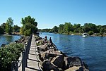
Oak Orchard Creek is a tributary of Lake Ontario in Orleans County, New York in the United States.

<span class="mw-page-title-main">New York State Route 279</span> State highway in Orleans County, New York, US

New York State Route 279 (NY 279) is a north–south state highway in Orleans County, New York, in the United States. The southern terminus of the route is at an intersection with NY 98 north of the village of Albion in the town of Gaines. Its northern terminus is at a junction with NY 18 in Carlton near where NY 18 meets the western end of the Lake Ontario State Parkway. The entirety of NY 279 north of NY 104 is maintained by Orleans County; south of NY 104, the route is maintained by the New York State Department of Transportation. NY 279 is a rural connector highway that serves only one community, the hamlet of Waterport on the banks of Oak Orchard Creek in Carlton.

References

  1. "2016 U.S. Gazetteer Files". United States Census Bureau. Retrieved July 5, 2017.
  2. 1 2 "Population and Housing Unit Estimates" . Retrieved June 9, 2017.
  3. "Representative Men of Chicago Pay Tribute to the Memory of Thomas Hoyne". Chicago Daily Tribune. Chicago. August 1, 1883. p. 3. Retrieved June 12, 2023 via Newspapers.com. The remains were interred at Rosehill Cemetery, the procession of carriages being a magnificent one.
  4. "Five teens charged with disrupting Muslim services". CNN. September 1, 2010. Retrieved September 1, 2010.
  5. "Point Breeze declared 'Ultimate Fishing Town' in U.S." Batavia Daily News. June 12, 2013. Archived from the original on June 13, 2013. Retrieved June 12, 2013.
  6. "Census of Population and Housing". Census.gov. Retrieved June 4, 2015.
  7. "U.S. Census website". United States Census Bureau . Retrieved January 31, 2008.

43°19′40″N78°11′27″W / 43.32778°N 78.19083°W / 43.32778; -78.19083