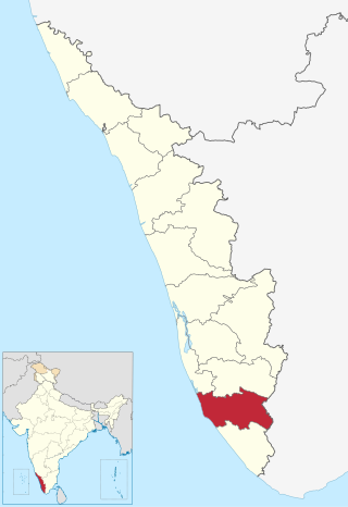
Kollam district, is one of 14 districts of the state of Kerala, India. The district has a cross-section of Kerala's natural attributes; it is endowed with a long coastline, a major Laccadive Sea seaport and an inland lake. The district has many water bodies. Kallada River is one among them, and land on the east bank of the river is East Kallada and that on the west bank is West Kallada.

Punkunnam is a commercial and residential area in Thrissur city of Kerala in India. It is 2 km away from the Swaraj Round. Punkunnam is home to the renowned Punkunnam Siva Temple. Sitaram Textiles is situated here. It was established in the early 1940s. The spinning wing has the capacity of 12,000 spindles. The mill also has a capacity to process 40,000 meters of cloth every day. Poonkunnam Railway Station provides rail connectivity to other parts of Kerala and India. Punkunnam is witnessing a real estate boom.
Adoor is a municipality in the Pathanamthitta district of Kerala, India. It is the headquarters of the Adoor Taluk and Adoor Revenue Division. Adoor is located 18 km (11.2 mi) southwest of the district headquarters Pathanamthitta and 85 km (52.8 mi) north of the state capital Thiruvananthapuram.

Pathanamthitta, is a city in southern Kerala, India, spread over an area of 23.5 km2 (9.1 sq mi). It is the administrative capital of Pathanamthitta district. The town has a population of 37,538. The Hindu pilgrim centre Sabarimala is situated in the Pathanamthitta district; as the main transport hub to Sabarimala, the town is known as the 'Pilgrim Capital of Kerala'. Pathanamthitta District, the thirteenth revenue district of the State of Kerala, was formed with effect from 1 November 1982, with headquarters at Pathanamthitta. Forest covers more than half of the total area of the District. Pathanamthitta District ranks the 7th in area in the State. The district has its borders with Allepey, Kottayam, Kollam and Idukki districts of Kerala and Tamil Nadu. Nearest town is Thiruvalla, located at a distance of 30 km. Thiruvalla railway station is 30 km via Thiruvalla-Kumbazha highway.
Punnala is a small village situated in Kollam district of Kerala, India. Punnala is located at a distance of 8 kilometers from both Pathanapuram and Punalur and 1 km from Chachipunna. It is in the Pathanapuram Taluk, Pathanapuram Assembly Constituency and Mavelikkara Parliament Constituency. Punnala is a part of Piravanthoor Grama Panchayth, Pathanapuram Block Panchayat and Kollam district Panchayat.

Thalavoor is a village located in the district of Kollam in the Kerala state of India. It is 77 km to the north of the State Capital, Thiruvananthapuram, and 28 km to the east of District Capital, Kollam. Thalavoor village is bordered by Pattazhy village to the north, Pidavoor village to the north-east, Vilakkudy village to the south-east, Melila village to the south and Mylom village to the west. Thalavoor is a part of Pathanapuram Block Panchayat

Pathanapuram is a Town in Pathanapuram Taluk Kollam district, Kerala, India. Pathanapuram is a part of Grama Panchayat and Block panchayat of same name and part of Kollam District Panchayat.

Konni, also spelt Konny, is a town and taluk headquarters in Pathanamthitta district of Kerala, India. Konni is known for its elephant cages, forests, and rubber plantations. It is also known as "Aanakoodinte Nadu". Nearest town is Pathanamthitta. Konni is located 32 km (20 mi) from Chengannur railway station and NH 183 in Chengannur. It is well-connected via Muvattupuzha - Punalur state highway. Buses ply frequently from Pathanamthitta KSRTC bus station to Konni.

The Kallada River is the longest river in Kollam District, Kerala, India. The river originates in Kulathupuzha, in the Western Ghats, and flows west, reaching the Arabian Sea after traveling a distance of 120 km (75 mi).

Aryankavu is a village located in the Kollam district of the Indian state of Kerala. It lies close to the border between Kerala and Tamil Nadu near Thenmala. It is also one of the famous pilgrimage sites associated with the legend of Sabarimala. The village is located beside Shendurney Wildlife Sanctuary.

The Main Eastern Highway is the lifeline of the high range townships of the midlands and highlands of eastern kerala Kerala state, India. It is also known as Punalur-Muvattupuzha Highway. Main Eastern Highway is categorized as State Highway - 08 of Kerala. It is the second longest State Highway of Kerala covering a distance of 153.6 km. The districts it passes through are Kollam, Pathanamthitta, Kottayam, Idukki and Ernakulam.

Koodal is the second largest town in Konni Taluk at Pathanamthitta District, located in Kerala state, India.Koodal Situates On Main Eastern Highway.
Kizhakkekallada, also known as East Kallada, is a large village in the Kollam district in the state of Kerala, India. It is located about 20 kilometres (12 mi) northeast of Kollam.
Vettikkavala is a village located in the Kollam district in the state of Kerala, India. The village is famous for Shiva-Vishnu temples which hosts a special deity called Vathukkal Njaali Kunju. An annual celebration of Pongala is held at the temple. The village is also well known for temple arts and a palace constructed by Sree Moolam Thirunal.
Enadimangalam is a village in the Pathanamthitta district of the state of Kerala, India. Enadimagalam includes mainly Elamanoor and Maroor. Enadimagalam is often recognised as a Panchayat. Enadimangalam had a population of around 30,000.

Kalanjoor is a village located in Pathanamthitta district state of Kerala, India. The place is 22 km away from district headquarters. As a part of Konni Assembly constituency and Pathanamthitta Lok Sabha constituency. Kalanjoor is also a panchayath where share the border of Kollam and Pathanamthitta district as the part of Parakode Block Panchayat.
Karavaloor is a village situated in Kollam district in the Indian state of Kerala. Karavaloor is mainly known for the famous temple Peedika Bhagavathi Temple and it's Meena-Thiruvathira Festival as it is one of the well known festival in kollam District. Thousands of people gather here every year for this very reason regardless of their caste or faith.
Hinduism, Islam and Christianity are the prominent religions in Kollam district. As per the Census 2011, out of the total population of 2,635,375 persons, 64.42% follow Hinduism, 19.30% follow Islam and 16.00% follow Christianity. Other religions comprise 0.04%, while 0.25% did not state any religion.
Avaneeswaram is a small village located on Kunnicode-Pathanapuram road in Kollam district, Kerala. It is about 7 kilometers south of Pathanapuram town and 36 kilometers from Kollam. It is a part of Vilakkudy panchayat. Avaneeswaram has a FCI storage facility. Economy of this village primarily is agricultural. Most common farm produce includes coconut, tapioca, areca, and cashews. Some rice cultivation is also seen.

Poonkulanji is a village in Kollam (Quilon) district of India's Kerala state.


