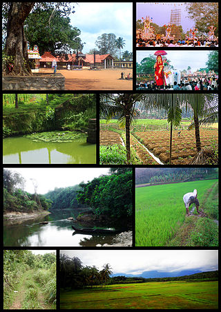
Cherupoika is a small village in the Kerala state of India. It is situated on the west side of Puthoor and in Kottarakkara taluk, in the district of Kollam and on the banks of the Kallada river.
Cherupoika is a small village in the Kerala state of India. It is situated on the west side of Puthoor and in Kottarakkara taluk, in the district of Kollam and on the banks of the Kallada river.
Tha name is derived from cheru (small) and poika (lake).
This small village is mainly dependent on agriculture. The area was covered with paddy fields, but most of these are now badly damaged by the mining of clay for bricks and a disappearing agricultural tradition. Old paddy fields are now big ponds and have converted this area into a big lake. In the near future, the area faces problems of unemployment, because of the shortage of clay for brick factories. Returning to agriculture is impossible because of severe damage to paddy fields and a shortage of ground water. The economy depends bricks manufacturing.
A scarcity of workers in this area attracts people from other states like West Bengal and Bihar, causing a social imbalance in the area. Many youths go outside the state and overseas, mainly to the Middle East, seeking jobs. Women are a major work force in the area in the brick factories and cashew factories in and around Puthur.
Inhabitants face many environmental hazards mainly because of a shortage of drinking water. Alcoholism is a main reason for social backwardness.
There are two schools, Vanivila Govt L.P.S. and Govt. L.P.S Cherupoika.
The nearest upper primary, high school, T.T.I. and V.H.S.C. is K.N.N.M.M Schools in Pavithreswaram.
Most of the inhabitants are Hindus, with a minority of Christians and Hindus living harmoniously. Cherupioka lord vishnu temple is the main worship centre for Hindus. There are two Christian churches.
A small canal connects the lake to Kallada river. A bridge connects the two sides of this area. Buses connect to the nearest places, but the roads in this area are severely damaged due to the lack of maintenance.
Two roads pass through, Puthoor-Pazhavara-Cherupoika-Pavithreswaram via Kollam and Puthoor-S.N Puram-Pannikkuzhi via Kallada.
This area is under the administration of Pavithreswaram panchayath and Pavithreswaram village, but there are no government offices. There is a post-office.
The nearest market is at Puthoor, nearly five kilometres away.

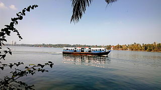
Ashtamudi Lake, in the Kollam District of the Indian state of Kerala is a unique wetland ecosystem and a large palm-shaped water body. It is second only in size to the Vembanad estuary ecosystem of the state. Ashtamudi means 'eight hills or peaks' in the local Malayalam language. The name is indicative of the lake's topography with its multiple branches. The lake is also called the gateway to the backwaters of Kerala and is well known for its houseboat and backwater resorts. Ashtamudi Wetland was included in the list of wetlands of international importance, as defined by the Ramsar Convention for the conservation and sustainable utilization of wetlands. Ashtamudi Estuary is the deepest among all the estuaries in Kerala, with a maximum depth of 6.4 meters at the confluence zone.
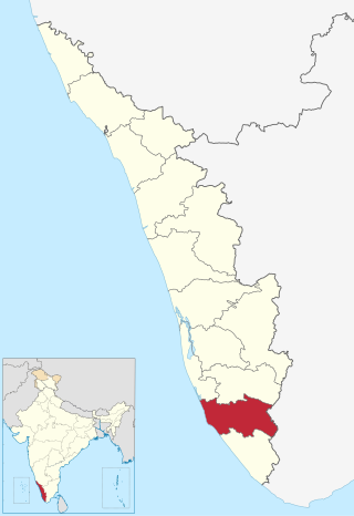
Kollam district, is one of 14 districts of the state of Kerala, India. The district has a cross-section of Kerala's natural attributes; it is endowed with a long coastline, a major Laccadive Sea seaport and an inland lake. The district has many water bodies. Kallada River is one among them, and land on the east bank of the river is East Kallada and that on the west bank is West Kallada.

Munroe Island or Mundrothuruthu is an inland island group located at the confluence of Ashtamudi Lake and the Kallada River, in Kollam district, Kerala, South India. It is a group of eight small islets comprising a total area of about 13.4 km2. The island, accessible by road, rail and inland water navigation, is about 25 kilometres (16 mi) from Kollam by road, 38 kilometres (24 mi) north from Paravur, 12 kilometres (7.5 mi) west from Kundara and about 25 kilometres (16 mi) from Karunagapally. As of the 2011 Indian census, the administrative village of Mundrothuruth has a total population of 9599, consisting of 4636 males and 4963 females. This island is also known as "Sinking Island of Kerala".

Kottarakkara, also transliterated as Kottarakara, is a town and municipality in the Kollam district of the Kerala, India. Kottarakkara lies 27 kilometres (17 mi) to the east of Kollam city centre.
Sooranad North is a village in Kollam district in the south west Indian state of Kerala. It is believed that Sooranad was ruled by King SOORAN and hence the name.

Punnavely is a village in Thiruvalla Constituency situated on the border of Pathanamthitta and Kottayam districts of Kerala, India. Punnavely is a typical Central Tranvancore village with rubber tree plantations, paddy fields, pepper and other spices and lot of NRIs.
Pattazhy, also Pattazhi is a village located in Pathanapuram taluk in the eastern part of the Kollam District, Kerala state, India. It is best known as the site of an ancient Bhagavathy temple, Pattazhy Devi Temple.

The Kallada River is the longest river in Kollam District, Kerala, India. The river originates in Kulathupuzha, in the Western Ghats, and flows west, reaching the Arabian Sea after traveling a distance of 120 km (75 mi).

Sasthamcotta Lake or Sasthamkotta Lake, also categorized as a wetland, is the largest fresh water lake in Kerala, a state of India on the south of the West Coast. The lake is named after the ancient Sastha temple located on its bank. It meets the drinking water needs of half million people of the Quilon district and also provides fishing resources. The purity of the lake water for drinking use is attributed to the presence of large population of larva called cavaborus that consumes bacteria in the lake water. The lake is a designated wetland of international importance under the Ramsar Convention since November 2002.

Puthur is a small town located 26 kilometers (16 mi) from Kollam City in Kollam District, Kerala, India.
Kudavattoor is a small village of the Kottarakara Taluk in the Kollam district of the Indian state of Kerala. In the local Malayalam language, kuda means "umbrella" and vattor "round". A predominantly rural village, Kudavattoor comes under the administration of the Veliyam Grama Panchayat made up of Maroor, Cherukarakonam and Kudavattoor chandhamukku. The village is situated on the odanavattom kollam road, which provides access to Kollam via Kundara or Nedumankavu as well as to Kottarakara. Kollam, the district headquarters is situated about 25 km from Kudavattoor.

Pavithreswaram is a village in Kottarakkara taluk of Kollam district in the state of Kerala, India.
Poothakkulam, also known as Bhoothakkulam, is a village in Kollam district in the state of Kerala, India. The village is located 3.9 km away from Paravur, 11.4 km from Varkala and 23 km from Kollam. In 2011, it had a population of 628,451 residents. The village covers an area of 16.56 km2.
Vettikkavala is a village located in the Kollam district in the state of Kerala, India. The village is famous for Shiva-Vishnu temples which hosts a special deity called Vathukkal Njaali Kunju. An annual celebration of Pongala is held at the temple. The village is also well known for temple arts and a palace constructed by Sree Moolam Thirunal.
West Kallada is a village in Kollam district in the state of Kerala, India.
Chandanathope is a town located in Kollam district, Kerala. It lies 23 kilometres (14 mi) from Paravur town and 8 kilometres (5.0 mi) from Kollam city centre on the Kollam–Thirumangalam National Highway 744. In Malayalam, the name denotes a place with sandalwood plantations. It is also known for cashew processing and its exports two major cashew exporters of Kollam namely VLC Cashews and MARK has their facilities in the town.
Iverkala is a rural village in Kollam district of Kerala state in India. The famous Kallada river flows through the village from east and south. On the other side of the river, Attuvassery is in the east and Thekkumchery is in the south. West side Kadampanadu and North Mannady.

Punthalathazham is a landlocked neighbourhood of the city of Kollam in the Indian state of Kerala. It is located around six kilometres east of the core Kollam (Quilon) city towards Kannanalloor . This place has a little geographical importance and serves as the tail boundary of Kollam Municipal Corporation. Inhabitants belong to working and middle classes.

Attuvassery is a village in Kollam district in the state of Kerala in southern India. The Kallada River flows through the village from east and south. On the other side of the river, Attuvassery is in the east and Thekkumchery is in the south, while on the west side are Kadampanadu and North Mannady.
Kollam district, earlier called Quilon district, is one of the 14 districts of Kerala state, India. The district is representative of all the natural attributes of Kerala states, and is endowed with a long coastal region, a major sea port on the Arabian Sea, plains and the mountains, lakes, lagoons and Kerala Backwaters, forests and the farm land, and rivers and streams. The area had mercantile relationship with Phoenicians and the Romans.
| City corporations |  | |
|---|---|---|
| Municipalities | ||
| Revenue divisional office | ||
| Talukas and villages | ||