
Gold Brook Covered Bridge, also known as Stowe Hollow Bridge or Emily's Bridge, is a small wooden covered bridge in the town of Stowe, Lamoille County, Vermont, carrying Covered Bridge Road over Gold Brook. Built in 1844, it is the only 19th-century covered bridge in the state built using wooden Howe trusses and carrying a public roadway. It was added to the National Register of Historic Places in 1974.

The Carpenter Bridge is a historic bridge carrying Carpenter Street over the West Branch Palmer River in Rehoboth, Massachusetts. Built in 1873, it is the only surviving 19th-century stone bridge in the town. The bridge was listed on the National Register of Historic Places in 1983.

The Stewart Creek Bridge or Bridge L6007 is a stone arch bridge in the Smithville neighborhood of Duluth, Minnesota, United States. It was built around 1925 as part of the scenic Skyline Parkway overlooking the city. The Stewart Creek Bridge was listed on the National Register of Historic Places in 1989 under the name Bridge No. L-6007 for its state-level significance in the theme of engineering. It was nominated for being the most picturesque stone arch road bridge in design and setting in Minnesota.

Watson Settlement Bridge was a historic covered bridge in eastern Littleton, Maine, United States. Built in 1911, it was one of the youngest of Maine's few surviving covered bridges. It formerly carried Framingham Road over the Meduxnekeag River, but was closed to traffic, the road passing over a modern bridge to its south. It was listed on the National Register of Historic Places in 1970. It was destroyed by fire on July 19, 2021, and subsequently delisted from the National Register in 2023.

The Halpin Covered Bridge, also called the High Covered Bridge, is a wooden covered bridge carrying Halpin Bridge Road across the Muddy Branch of the New Haven River in Middlebury, Vermont. It was listed on the National Register of Historic Places in 1974.

The Lower Cox Brook Covered Bridge is a wooden covered bridge that crosses Cox Brook in Northfield, Vermont on Cox Brook Road. Built in 1872, it is one of five surviving 19th-century covered bridges in the town, in the only place in Vermont where two historic bridges are visible from each other. It was listed on the National Register of Historic Places in 1974.

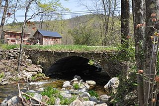
The East Putney Brook Stone Arch Bridge is a historic stone arch bridge in eastern Putney, Vermont. Built in 1902, it is a rare statewide example of a 20th-century stone bridge, and one of a number of such area bridges built by Townshend farmer and mason James Otis Follett. It was listed on the U.S. National Register of Historic Places in 1976. The bridge is located just west (upstream) of the present alignment of River Road, which it formerly carried.

Bridge No. 1860, also known as the Samson Occom Bridge, is a fieldstone arch bridge in Montville, Connecticut, United States. Constructed by the Connecticut State Highway Department in 1936 as a Works Progress Administration project, it is located on Mohegan tribal land in an area that was once a part of Fort Shantok State Park. The bridge carries traffic from Massapeag Side Road over the Shantok Brook, a tributary of the Thames River. Spanning 12 feet (3.7 m) across the brook, the bridge's arch rises about 6 feet (1.8 m) above the water. According to a 2011 Connecticut Department of Transportation report, it carries 1,100 vehicles per day. Samson Occom Bridge was listed on the National Register of Historic Places in 1993.

The Gilsum Stone Arch Bridge carries Surry Road over the Ashuelot River in Gilsum, New Hampshire. Built in 1862–63, it is one of the highest stone arch bridges in the state. It has a span of 47 feet 8 inches (14.53 m), and an average height over the river of 36 feet 6 inches (11.13 m). The roadway is 43 feet 6 inches (13.26 m) above the riverbed. It stands on the site of four previous bridges, where the river passes through a deep gorge. The previous bridge was also a stone arch bridge, which was built in 1860 and collapsed a few months later. It was designed by William Leonard Kingsbury, a local official; its builders are not known because the town's records were destroyed in a fire. The present bridge's vault is carefully constructed from dry-laid granite voussoirs that were shaped for a very precise fit, with larger stones at the lower ends of the arch, and a smaller ones at the crown. Some of the stones were left with rough surfaces, while others were hammered smooth.

The Samuel Morey Memorial Bridge is a historic bridge carrying New Hampshire Route 25A across the Connecticut River between Orford, New Hampshire and Fairlee, Vermont. The steel through-arch bridge was built in 1937–38 to replace an older wooden bridge which had been damaged by flooding in 1936. It spans 432 feet (132 m), stands about 35 feet (11 m) above the river, and its arches rise 85 feet (26 m) above the roadway. It rests on poured concrete abutments that have a light Art Deco or Moderne styling. Wing walls recede from the abutments into the banks in three stepped sections. Below the bridge in the river is visible some riprap, stone remnants of the old bridge's abutments and central pier. The bridge is of a "tied arch" design, in which the two arches are joined together by ties to distribute the active load. This is in contrast to the Justice Harlan Fiske Stone Bridge joining Brattleboro, Vermont and Chesterfield, New Hampshire, which was built about the same time, and distributes the active load to its abutments. The bridge components were manufactured by the American Bridge Company; construction was by Hagen-Thibodeau Construction Company at a contracted cost of just over $209,000.

The Meriden Bridge is a historic covered bridge in the Meriden area of Plainfield, New Hampshire. The bridge is a single span which carries Colby Hill Road over Bloods Brook, just west of a junction with Main Street and Willow Brook Road. Built about 1880, it is one of New Hampshire's few surviving 19th-century covered bridges. It was listed on the National Register of Historic Places in 1980.

The Gilead Brook Bridge was an historic bridge which carried Vermont Route 12 across Gilead Brook north of the center of Bethel, Vermont. Built in 1928, it was one of four multi-span Warren deck truss bridges built in the state after extensive flooding in 1927. It was listed on the National Register of Historic Places in 1990. It was replaced in 2019-2020.

Thompson's Bridge is a historic stone bridge in rural Franklin County, Maine. Built c. 1808, it is one of a very small number of surviving stone lintel bridges in the state, a type that were once quite common. It carries a local dirt road across Josiah Creek in the Allen's Mills section of Industry, and is located near the border with neighboring Somerset County. The bridge was listed on the National Register of Historic Places in 1991.

The Follett Stone Arch Bridge Historic District encompasses a group of four stone arch bridges in southwestern Townshend, Vermont. All four bridges were built by James Otis Follett, a local self-taught mason, between 1894 and 1910, and represent the single greatest concentration of surviving bridges he built. The district was listed on the National Register of Historic Places in 1976.

The Sacketts Brook Stone Arch Bridge, also known locally as the Hi-Lo Biddy Stone Arch Bridge, is a historic bridge just outside the village of Putney, Vermont. It is a stone arch bridge that formerly carried Mill Street across Sacketts Brook, about 0.25 miles (0.40 km) east of United States Route 5. It was built in 1906 by James Otis Follett, an area stonemason, and is one of a few surviving examples of his work. The bridge was listed on the National Register of Historic Places in 1976.
The Simpsonville Stone Arch Bridge is a historic stone arch bridge, carrying Vermont Route 35 across Simpson Brook, north of the village of Townshend, Vermont. Built about 1909, it is one of a few surviving bridges in the region built by local mason James Otis Follett. It was listed on the National Register of Historic Places in 1977.

The West Townshend Stone Arch Bridge carries Round Hill Road across Tannery Brook in the village of West Townshend, Vermont. Built about 1910, it is one of the few surviving bridges of a group built by local mason James Otis Follett in the early 20th century. It was listed on the National Register of Historic Places in 1977.

Best's Covered Bridge(akaSwallow's Bridge) is a historic covered bridge in West Windsor, Vermont, that carries Churchill Road over Mill Brook, just south of Vermont Route 44. Built in 1889, it is an architecturally distinctive laminated arch structure with a post-and-beam superstructure. It was listed on the National Register of Historic Places in 1973.
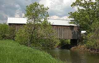
The Howe Covered Bridge is a historic covered bridge carrying Belknap Brook Road across the White River in Tunbridge, Vermont, just east of Vermont Route 110. Built in 1879, it is one of five surviving bridges in the town, one of the highest concentrations of covered bridges in the state. It was listed on the National Register of Historic Places in 1974.

The Sheffield Street Bridge is a historic lenticular truss bridge spanning Hancock Brook in Waterbury, Connecticut, United States. Built in 1884, it is a rare example of a wrought iron bridge built by the Berlin Iron Bridge Co., and one of the few surviving lenticular truss bridges left in the state. It was listed on the National Register of Historic Places in 2001.


