
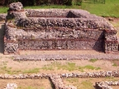
Termini Imerese is a town of the Metropolitan City of Palermo on the northern coast of Sicily, in Italy. It is one of the most important towns of the Metropolitan City of Palermo, from which it is 33 km away. The town is easily reachable through its well developed infrastructures: there are three highway exits along the A19, its station is the meeting point between all of the Sicilian railway lines and its seaport links the town with other important maritime Italian cities. It has a judicial district. It's culturally interesting for the close Greek ruins of Himera, its numerous churches, Roman ruins, prehistorical finds and the annual celebration of the Carnival, one of the oldest of Italy. In the heart of the old town, at its lower level, there are the thermal baths of the Grand Hotel delle Terme, where precious hot waters flow since Roman age. In the areas of Termini and the near Sciara and Caccamo there's the Oriented Nature Reserve of Mount St. Calogero, which is located between the coast of Termini Imerese Gulf and the surrounding fertile flat territory. In the east zone of the town, there's an important industrial area, especially known for the former factory which was owned by FIAT and for the ENEL power plant “Ettore Majorana”.
Sulci or Sulki, was one of the most considerable cities of ancient Sardinia, situated in the southwest corner of the island, on a small island, now called Isola di Sant'Antioco, which is, however, joined to the mainland by a narrow isthmus or neck of sand. South of this isthmus, between the island and the mainland, is an extensive bay, now called the Golfo di Palmas, which was known in ancient times as the Sulcitanus Portus (Ptol.).

Isernia is a town and comune in the southern Italian region of Molise, and the capital of the province of Isernia.

Manduria is a city and comune of Apulia, Italy, in the province of Taranto. With c. 32,000 inhabitants (2013), it is located 35 kilometres (22 mi) east of Taranto.

The Umbri were an Italic people of ancient Italy. A region called Umbria still exists and is now occupied by Italian speakers. It is somewhat smaller than the ancient Umbria.

Agira is a town and comune in the province of Enna, Sicily. It is located in the mid-valley of the River Salso, 35 kilometres from Enna. Until 1861 it was called San Filippo d'Argiriò, in honour of its saint Philip of Agira.

Gortyna was a town of ancient Crete which appears in the Homeric poems under the form of Γορτύν; but afterwards became usually Gortyna (Γόρτυνα). According to Stephanus of Byzantium it was originally called Larissa (Λάρισσα) and Cremnia or Kremnia (Κρήμνια).
Usellus is a town, comune (municipality) and former bishopric in the Province of Oristano in the Italian region Sardinia.

The Frentani were an Italic tribe occupying the tract on the southeast coast of the Italian peninsula from the Apennines to the Adriatic, and from the frontiers of Apulia to those of the Marrucini. They were bounded on the west by the Samnites, with whom they were closely connected, and from whom they were originally descended. Hence Scylax assigns the whole of this line of coast, from the frontiers of Apulia to those of Picenum, to the Samnites. Their exact limits are less clearly defined, and there is considerable discrepancy in the statements of ancient geographers: Larinum, with its territory, being by some writers termed a city of the Frentani, while the more general opinion included it in Apulia, and thus made the river Tifernus the limit of the two countries. The northern boundary of the Frentani is equally uncertain; both Strabo and Ptolemy concur in fixing it at the river Sagrus, while Pliny extends their limits as far as the Aternus, and, according to Mela, they possessed the mouths both of that river and the Matrinus. The latter statement is certainly inaccurate; and Strabo distinctly tells us that the Marrucini held the right bank of the Aternus down to its mouth, while the Vestini possessed the left bank; hence, the former people must have intervened between the Frentani and the mouth of the Aternus. Pliny's account is, however, nearer the truth than that of Strabo and Ptolemy; for it is certain that Ortona and Anxanum, both of which are situated considerably to the north of the Sagrus, were Frentanian cities. The latter is indeed assigned by Ptolemy to that people, while Strabo also terms Ortona the port or naval station of the Frentani, but erroneously places it to the south of the river Sagrus. Hence, their confines must have approached within a few miles of the Aternus, though without actually abutting upon that river. On the west, they were probably not separated from the Samnites by any well-marked natural boundary, but occupied the lower slopes of the Apennines as well as the hilly country extending from thence to the sea, while the more lofty and central ridges of the mountains were included in Samnium.
Monteu da Po is a small comune in the Metropolitan City of Turin, Piedmont, Italy, 32 km north-east of Turin.

Troia is a town and comune in the province of Foggia and region of Apulia in southern Italy.

Castelvecchio Subequo is a comune and town in the province of L'Aquila in the Abruzzo region, central Italy, at the feet on Mount Sirente.

San Benedetto dei Marsi is a comune and town in the province of L'Aquila in the Abruzzo region of central Italy. It is on the eastern shore of the dried Lake Fucino, 20 kilometres (12 mi) from the remains of another ancient site, Alba Fucens.

Lete was an ancient city in Mygdonia, Macedon and Roman Catholic titular see in the Roman province of Macedonia.

Montesarchio is a comune in the Province of Benevento, Campania, Southern Italy. It is located 18 kilometres southwest of Benevento in the Valle Caudina at the foot of Monte Taburno. The commune was granted the official status of city (città) by a presidential decree of 31 July 1977. In 2020, it had a population of 13,226. It is a member of the I Borghi più belli d'Italia association.
San Marco d'Alunzio is a city and comune (municipality) in the Metropolitan City of Messina in the Italian region Sicily, near the north coast of the island, located about 120 kilometres (75 mi) east of Palermo and about 80 kilometres (50 mi) west of Messina.

Trebula or Trebula Balliensis or Trebula Baliensis, was an ancient city of Campania, Italy, the location of which is occupied by the modern village of Treglia in the comune of Pontelatone. The Monti Trebulani, a small mountain group in the modern province of Caserta, take their name from it.
Trebula or Trebula Suffenas or Trebula Suffenes, was an ancient city of the Sabines, one of two bearing the name Trebula – Pliny being the only author who mentions both places: Trebulani qui cognominantur Mutuscaei, et qui Suffenates.
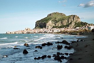
Cefalù, classically known as Cephaloedium, is a city and comune in the Italian Metropolitan City of Palermo, located on the Tyrrhenian coast of Sicily about 70 km (43 mi) east of the provincial capital and 185 km (115 mi) west of Messina. The town, with its population of just under 14,000, is one of the major tourist attractions in the region. Despite its size, every year it attracts millions of tourists from all parts of Sicily, and also from all over Italy and Europe. It is a member of the I Borghi più belli d'Italia association.
Sinuessa was a city of Latium, in the more extended sense of the name, situated on the Tyrrhenian Sea, about 10 km north of the mouth of the Volturno River. It was on the line of the Via Appia, and was the last place where that great highroad touched on the sea-coast. The ruins of the city are located in the modern-day municipality of Sessa Aurunca ,The hamlet is, as the crow flies, 12.24 Km from the Municipality of Sessa Aurunca and 41.43 Km from the Province of Caserta. It is 26.71 km from the regional capital (Naples/Napoli) Campania, Italy.


