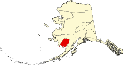
Clark's Point, Alaska

Last updated

Clark's Point, Alaska
Saguyaq
Country Flag of the United States.svg  United States
State Flag of Alaska.svg  Alaska
Census area Dillingham
Government
   Mayor Harry Wassily, Sr. [1]
   State senator Lyman Hoffman (D) [2]
   State rep. Bryce Edgmon (I)
Area
[3]
  Total4.11 sq mi (10.64 km2)
  Land3.32 sq mi (8.61 km2)
  Water0.79 sq mi (2.03 km2)
Population
 (2020)
  Total67
  Density20.16/sq mi (7.78/km2)
Time zone UTC-9 (Alaska (AKST))
  Summer (DST) UTC-8 (AKDT)
ZIP code
99569 [4]
Area code 907
FIPS code02-15430 [5]
GNIS 1400426 [5]

Clark's Point (Central Yupik : Saguyaq) is a city in Dillingham Census Area, Alaska, United States. The population was 62 at the 2010 census.

Contents

Geography

Clark's Point is located at 58°49′57″N158°33′09″W / 58.832560°N 158.552542°W / 58.832560; -158.552542 . [6]

According to the United States Census Bureau, the city has a total area of 4.1 square miles (11 km2), of which, 3.1 square miles (8.0 km2) of it is land and 0.9 square miles (2.3 km2) of it (22.66%) is water.

Demographics

Historical population
CensusPop.Note
1890 7
1930 25
1940 22−12.0%
1950 128481.8%
1960 1387.8%
1970 95−31.2%
1980 79−16.8%
1990 60−24.1%
2000 7525.0%
2010 62−17.3%
2020 678.1%
U.S. Decennial Census [7]

Clark's (or Clarks) Point first appeared on the 1890 U.S. Census as the unincorporated Inuit village of "Stugarok." [8] It would not appear again until 1930, when it returned as Clark's Point, also an unincorporated village. It formally incorporated in 1971.

As of the census [9] of 2000, there were 75 people, 24 households, and 15 families residing in the city. The population density was 23.9 inhabitants per square mile (9.2/km2). There were 51 housing units at an average density of 16.2 units per square mile (6.3 units/km2). The racial makeup of the city was 6.67% White, 90.67% Native Alaskan, 1.33% Pacific Islander, and 1.33% from two or more races.

There were 24 households, out of which 33.3% had children under the age of 18 living with them, 45.8% were married couples living together, 16.7% had a female householder with no husband present, and 37.5% were non-families. 25.0% of all households were made up of individuals, and 4.2% had someone living alone who was 65 years of age or older. The average household size was 3.13 and the average family size was 3.93.

In the city, the population was spread out, with 38.7% under the age of 18, 6.7% from 18 to 24, 25.3% from 25 to 44, 21.3% from 45 to 64, and 8.0% who were 65 years of age or older. The median age was 30 years. For every 100 females, there were 114.3 males. For every 100 females age 18 and over, there were 119.0 males.

The median income for a household in the city was $28,125, and the median income for a family was $41,250. Males had a median income of $30,625 versus $41,250 for females. The per capita income for the city was $10,988. There were 20.0% of families and 45.7% of the population living below the poverty line, including 66.7% of under eighteens and 36.4% of those over 64.

Education

It was previously served by the Clarks Point School, operated by the Southwest Region School District. Due to declining enrollment, the school closed in May 2012. [10] The Clark's Point school re-opened in August 2017. [11]

Related Research Articles

<span class="mw-page-title-main">Dillingham Census Area, Alaska</span> Census area in Alaska, United States

Dillingham Census Area is a census area located in the state of Alaska, United States. At the 2020 census, the population was 4,857, slightly up from 4,847 in 2010. It is part of the unorganized borough and therefore has no borough seat. Its largest community by far is the city of Dillingham, on a small arm of Bristol Bay on the Bering Sea.

Manokotak is a city in Dillingham Census Area, Alaska, United States. At the 2010 census the population was 442, up from 399 in 2000.

<span class="mw-page-title-main">New Stuyahok, Alaska</span> City in Alaska, United States

New Stuyahok is a city in Dillingham Census Area, Alaska, United States. At the 2010 census the population was 510, up from 471 in 2000.

<span class="mw-page-title-main">Portage Creek, Alaska</span> Census-designated place in Alaska, United States

Portage Creek is a census-designated place (CDP) in Dillingham Census Area, Alaska, United States. The population was 2 at the 2010 census, down from 36 at the 2000 census.

<span class="mw-page-title-main">Crown Point, Alaska</span> Census-designated place in Alaska, United States

Crown Point is a census-designated place (CDP) in Kenai Peninsula Borough, Alaska, United States. The population was 74 at the 2010 census. Land access to this area is by either the Alaska Railroad or the Seward Highway.

<span class="mw-page-title-main">Port Lions, Alaska</span> City in Alaska, United States

Port Lions is a city located on Kodiak Island in the Kodiak Island Borough of the U.S. state of Alaska. As of the 2010 census, the population of the city was 194, down from 256 in 2000.

<span class="mw-page-title-main">Pilot Point, Alaska</span> City in Alaska, United States

Pilot Point is a city in Lake and Peninsula Borough, Alaska, United States, on the Alaska Peninsula. As of the 2020 census, the population of the city was 70, up from 68 in 2010.

<span class="mw-page-title-main">Port Alsworth, Alaska</span> Census-designated place in Alaska, United States

Port Alsworth is a census-designated place (CDP) in Lake and Peninsula Borough, Alaska, United States. It is 165 miles (266 km) by air southwest of Anchorage. Its population was 186 at the 2020 census, up from 159 in 2010. It is the most populated community in the borough.

<span class="mw-page-title-main">Port Heiden, Alaska</span> City in Alaska, United States

Port Heiden is a city in Lake and Peninsula Borough, Alaska, United States. As of the 2020 census, the population of the city is 100, slightly down from 102 in 2010.

<span class="mw-page-title-main">White Mountain, Alaska</span> City in Alaska, United States

White Mountain is a city in Nome Census Area, Alaska, United States. The population was 190 at the 2010 census, down from 203 in 2000. The city is an Iġaluŋmiut Inupiat village, with historical influences from and relationships with Qawiaraq Inupiat and Golovin and Elim Yup’iks. 86.2% of the population is Alaska Native or part Native. Subsistence activities are prevalent. White Mountain is the only village on the Seward Peninsula located inland, not on the ocean.

<span class="mw-page-title-main">Tenakee Springs, Alaska</span> City in Alaska, United States

Tenakee Springs is a city on Chichagof Island in Hoonah-Angoon Census Area, Alaska, United States. At the 2010 census the population was 131, up from 104 at the 2000 census.

<span class="mw-page-title-main">Chistochina, Alaska</span> CDP in Alaska, United States

Chistochina is a census-designated place (CDP) in Copper River Census Area, Alaska, United States. At the 2020 census the population was 60, down from 93 in 2010.

<span class="mw-page-title-main">Port Alexander, Alaska</span> City in Alaska, United States

Port Alexander is a city at the southeastern corner of Baranof Island in Prince of Wales-Hyder Census Area, Alaska, United States. At the 2010 census the population was 52, down from 81 in 2000.

<span class="mw-page-title-main">Central, Alaska</span> CDP in Alaska, United States

Central is a census-designated place (CDP) in Yukon-Koyukuk Census Area, Alaska, United States. At the 2010 census the population was 96, down from 134 in 2000. Every February, Central hosts a checkpoint for the long-distance Yukon Quest sled dog race.

<span class="mw-page-title-main">Chalkyitsik, Alaska</span> CDP in Alaska, United States

Chalkyitsik( CHAL-key-IT-sick), meaning "to fish with a hook, at the mouth of the creek", is a census-designated place (CDP) in Yukon-Koyukuk Census Area, Alaska, United States. It is located on the left (south) bank of the Black River, 45 miles northeast of Fort Yukon. At the 2010 census the population was 69, down from 83 in 2000.

<span class="mw-page-title-main">Gridley, Kansas</span> City in Coffey County, Kansas

Gridley is a city in Coffey County, Kansas, United States. As of the 2020 census, the population of the city was 313.

<span class="mw-page-title-main">Cambridge, Kansas</span> City in Cowley County, Kansas

Cambridge is a city in Cowley County, Kansas, United States. As of the 2020 census, the population of the city was 92.

<span class="mw-page-title-main">Mayfield, Kansas</span> City in Sumner County, Kansas

Mayfield is a city in Sumner County, Kansas, United States. As of the 2020 census, the population of the city was 75.

<span class="mw-page-title-main">Rogers, North Dakota</span> City in North Dakota, United States

Rogers is a city in Barnes County, North Dakota, United States. The population was 49 at the 2020 census. Rogers was founded in 1897.

<span class="mw-page-title-main">Geuda Springs, Kansas</span> City in Cowley and Sumner County, Kansas

Geuda Springs is a city in Cowley and Sumner counties in the U.S. state of Kansas. As of the 2020 census, the population of the city was 158.

References

  1. 2023 Alaska Municipal Officials Directory (PDF). Juneau: Alaska Municipal League. January 2023. p. 57. Retrieved November 12, 2023.
  2. "Senator Lyman Hoffman". Alaska Senate Majority. Alaskasenate.org. Archived from the original on April 8, 2020. Retrieved November 16, 2019.
  3. "2020 U.S. Gazetteer Files". United States Census Bureau. Retrieved October 29, 2021.
  4. "Clarks Point ZIP Code". zipdatamaps.com. 2022. Retrieved November 11, 2022.
  5. 1 2 "Feature Detail Report for: Clarks Point". Geographic Names Information System . United States Geological Survey . Retrieved June 17, 2020.
  6. "US Gazetteer files: 2010, 2000, and 1990". United States Census Bureau. February 12, 2011. Retrieved April 23, 2011.
  7. "Census of Population and Housing". Census.gov. Retrieved June 4, 2015.
  8. "Geological Survey Professional Paper". 1949.
  9. "U.S. Census website". United States Census Bureau . Retrieved January 31, 2008.
  10. "Clarks Point Archived 2018-10-30 at the Wayback Machine ." Southwest Region School District. Retrieved on March 26, 2017.
  11. " Archived 2018-10-30 at the Wayback Machine ." Southwest Region School District. Retrieved on September 14, 2017.

58°49′57″N158°33′09″W / 58.83256°N 158.552542°W / 58.83256; -158.552542