
Highway 103 is a designation for two north–south state highways in north central Arkansas. One segment of 23.86 miles (38.40 km) runs north from Marina Road and Lakeview Drive in Clarksville to Highway 215 in the Ozark National Forest. A second route of 39.81 miles (64.07 km) begins at Highway 43 in the Buffalo National River area administered by the National Park Service and runs north across US Highway 412 (US 412) to Highway 21 in Oak Grove.

Beaufort Historic District is a historic district in Beaufort, South Carolina. It was listed on the National Register of Historic Places in 1969, and was declared a National Historic Landmark in 1973.
The Rockport Downtown Main Street Historic District encompasses part of the historic center of Rockport, Massachusetts. The district extends along Main Street, from its junction with Beach Street in the west to just east of its junction with School Street. The area is just west of Rockport's noted Bearskin Neck area. Most of the 28 properties in the district are commercial buildings; there are also three churches, a library, and a number of residences. Only a few of these properties front on the side streets adjacent to Main Street; all abut Main Street. The central focal point of the district is the First Congregational Church, built 1803, and the adjacent Federal style Jewett House, a pastor's residence built in 1806. Most of the commercial buildings are modest in scale, and are in a variety of building styles popular in the 19th century.

U.S. Route 64 is a U.S. highway running from Teec Nos Pos, Arizona east to Nags Head, North Carolina. In the U.S. state of Arkansas, the route runs 246.35 miles (396.46 km) from the Oklahoma border in Fort Smith east to the Tennessee border in Memphis. The route passes through several cities and towns, including Fort Smith, Clarksville, Russellville, Conway, Searcy, and West Memphis. US 64 runs parallel to Interstate 40 until Conway, when I-40 takes a more southerly route.

Albert Oscar Clark (1858–1935), commonly known as A.O. Clark, was an American architect who worked in Arkansas in the early 1900s.
Clarksville High School is a comprehensive public high school serving students in grades ten through twelve in Clarksville, Arkansas, United States. It is one of four public high schools in Johnson County and is the sole high school administered by the Clarksville School District. In 2012, Clarksville High School was nationally recognized as a bronze medalist by the U.S. News & World Report in its ranking of Best High Schools.

The First Presbyterian Church is a historic church building at 212 College Avenue in Clarksville, Arkansas. It is a two-story steel-framed structure, finished in brick. It is rectangular, with a central sanctuary flanked on the sides by office and meeting spaces. At the center of its roof is a dome, which is obscured by gabled parapets on the street-facing facades. The church was designed by Rogers based architect A.O. Clarke, and was completed in 1922 for a congregation founded in 1840. It is the finest example of Classical Revival architecture in Johnson County.

The El Dorado Commercial Historic District encompasses the historic commercial heart of downtown El Dorado, Arkansas. The city serves as the seat of Union County, and experienced a significant boom in growth during the 1920s, after oil was discovered in the area. The business district that grew in this time is anchored by the Union County Courthouse, at the corner of Main and Washington Streets, where the Confederate memorial is also located. The historic district listed on the National Register of Historic Places in 2003 includes the city blocks surrounding the courthouse, as well as several blocks extending east along Main Street and south along Washington Street. Most of the commercial buildings are one and two stories in height and are built of brick. Notable exceptions include the Exchange Bank building, which was, at nine stories, the county's first skyscraper, and the eight-story Murphy Oil building. There are more than forty contributing properties in the district.

The Fordyce Commercial Historic District encompasses the historic heart of Fordyce, Arkansas, the county seat of Dallas County. It encompasses four city blocks of North Main Street, between 1st and 4th, and includes properties on these adjacent streets. Fordyce was founded in 1882, and the oldest building in the district, the Nutt-Trussell Building at 202 North Main Street, was built c. 1884. Spurred by the logging industry and the Cotton Belt Railroad, Fordyce's downtown area had 25 buildings by 1901, and continued to grow over the next few decades, resulting in a concentration of period commercial architecture in its downtown. The district was listed on the National Register of Historic Places in 2008.

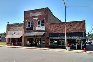
The Paragould Downtown Commercial Historic District encompasses the historic central business district of Paragould, Arkansas. The city was organized in 1882 around the intersection of two railroad lines, which lies in the southwestern portion of this district. The main axes of the district are Court and Pruett Streets, extending along Court from 3½ Street to 3rd Avenue, and along Court from King's Highway to Highland Street, with properties also on adjacent streets. Prominent in the district are the 1888 Greene County Courthouse, built during the city's first major growth spurt. Most of the district's buildings are one and two stories in height, and of masonry construction. The National Bank of Commerce Building at 200 S. Pruett is a notable example of limestone construction, and of Classical Revival styling found in some of the buildings put up during the city's second major growth period in the 1920s.

The Hardy Downtown Historic District encompasses most of the central business district of the resort community of Hardy, Arkansas. It extends along Main Street, between Church and Cope Streets, and includes a few buildings on adjacent streets. Hardy was founded as a railroad town in the 1880s, but grew by the end of the 19th century into a resort community, serving as commercial center for vacationers from Memphis, Tennessee. Most of the 43 buildings in the district are between one and three stories in height, and of masonry construction. Twenty-four are historically significant, and many of the remaining buildings date to the early 20th century but have been altered in unsympathetic ways. Notable buildings include the Hardy Church of Christ, and the Raymond Daugherty House, one of the community's oldest buildings.

The Siloam Springs Downtown Historic District encompasses the historic downtown area of Siloam Springs, Arkansas. The district is roughly bounded by University Street, Broadway, and Sager Creek, with a few buildings on adjacent streets outside this triangular area. This business district was developed mainly between about 1896, when the railroad arrived, and 1940, and contains a significant number of buildings dating to that period. It also includes Siloam Springs City Park, the location of the springs that gave the city its name. Notable buildings include the First National Bank building, a c. 1890 Romanesque Revival building, and the c. 1881 Lakeside Hotel, which is one of the city's oldest commercial buildings.

The Mena Commercial Historic District encompasses the historic downtown area of Mena, Arkansas, the county seat of Polk County in western Arkansas. The district extends along Mena Street between Port Arthur and Gillham Avenues, extending a short way to the south on Sherwood Avenue, opposite the railroad tracks for which the town's existence is responsible. Mena was founded as a major railroad service town for the Kansas City, Pittsburg and Gulf Railroad, as its site was located midway between Port Arthur, Texas and Kansas City, Missouri. The railroad located a major service yard here, and the town grew up around it. Most of its commercial center was developed between 1896 and 1940, with a variety of one and two-story commercial brick buildings in typical early 20th-century styles. The district, listed on the National Register of Historic Places in 2009, includes four properties previously listed separately: the railroad station, Mena City Hall, the former Elks Lodge, and the former Studebaker Showroom.

The Batesville Commercial Historic District encompasses about four city blocks of the historic downtown of Batesville, Arkansas. This area's current appearance is largely the result of development between about 1880 and the 1940s, although it includes a portion of Arkansas' oldest platted Main Street, dating to 1821. When originally listed on the National Register of Historic Places in 1982, the district included 25 historic properties on two blocks of Main Street, on either side of Central Avenue, as well as a few properties on Central. In 1990 the size of the district was more than doubled, adding two more city blocks on Main Street and 36 buildings. Most of the buildings are brick and masonry commercial structures, two stories in height, with party walls joining them at the sides.
The Lonoke Downtown Historic District encompasses a portion of the central business district of Lonoke, Arkansas. It extends south along Center Street, from the Lonoke County Courthouse to Front Street, and then one block east and west on both sides of Front Street. It extends eastward on the south side of Front Street another 1-1/2 blocks. Lonoke was founded as a railroad community in 1862, and this area represents the core of its downtown area for the period 1900–1945. Most of the district's 23 buildings are commercial structures, one to two stories in height, with brick facades.

The Dardanelle Commercial Historic District encompasses the part of the historic central business district of Dardanelle, Arkansas. The district extends along Front Street, from Pine Street in the north to nearly Oak Street in the south, and includes some properties on adjacent cross streets. Although this area has been commercially active since the 1820s, its present architecture reflects the late 19th and early 20th centuries, with modestly scaled one and two story masonry building predominating.

The Clarksville National Guard Armory is a historic former National Guard Armory at 309 College Street in Clarksville, Arkansas. It is a two-story building, finished in brick with restrained Art Deco styling. Its main facade is 10 bays wide, with a projecting section at the center housing two bays on the upper floor, and a double door entrance on the first. The entrance is set in a stepped recess, and it and the windows above are flanked by brick pilasters at the corner of the projection. The building was built in 1930, and served the Arkansas National Guard as a training and storage facility until 1980, after which ownership was turned over to the city.

The Johnson County Courthouse is located at Main and Fulton Streets in downtown Clarksville, the county seat of Johnson County, Arkansas. It is a three-story masonry structure, built out of brick and rusticated concrete blocks. It has a Classical Revival facade, with a seven-bay projecting section. Windows and entrances on the ground floor are set in round-arch openings, while the upper level windows are rectangular sash, set in bays articulated by pilasters. It was built in 1934 with funding support from the Federal Emergency Administration, and is the county's third courthouse.

The Missouri-Pacific Depot-Clarksville is a historic railroad station between Cherry and Main Streets in Clarksville, Arkansas. It is a single-story masonry structure, built in 1910 by the Missouri-Pacific Railroad in the Mediterranean style. It is basically rectangular, with a projecting cross-gabled telegrapher's booth on the track side, which is topped by a distinctive parapeted gable. The roof has extended eaves supported by large Italianate brackets.
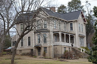
The Pennington House is a historic house at 317 Johnson Street in Clarksville, Arkansas. It is a 2 1⁄2-story wood-frame structure, with a complex cross-gabled plan, weatherboard siding, and a stuccoed brick foundation. It has an eclectic blend of Italianate and Folk Victorian features, including paired brackets in its eaves, moulded hoods over its sash windows, and a decorated porch. The house was built in 1888-89 by B.D. Pennington.


