
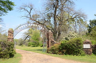
Camp Nelson Confederate Cemetery is a historic cemetery located near Cabot in northern Lonoke County, Arkansas and is near the site of a Confederate military camp Camp Hope, where 1,500 Confederate soldiers died during an epidemic during the fall of 1862. Camp Nelson Cemetery is located on Rye Drive, just off Cherry Road, just off Mt. Carmel Road in north Lonoke County about 2 miles east of Cabot.

The Signer's House and Matthew Thornton Cemetery are a pair of historic properties in Merrimack, New Hampshire, United States. It consists of a house, once owned by Matthew Thornton, a signer of the United States Declaration of Independence, and the adjacent cemetery in which he is buried. The house is a two-story Georgian style double house, and is the only surviving house of the period in Merrimack. It was owned by Thornton from 1780 to 1797, when he sold it to his son James. The cemetery, located across the Daniel Webster Highway from the house, is also Merrimack's first cemetery, with the oldest gravestone marked 1742.

This is a list of the National Register of Historic Places listings in Cleburne County, Arkansas.

Holly Grove Cemetery is a historic cemetery, located on the south side of Crooked Bayou Drive, 3 miles (4.8 km) southeast of McGehee, Arkansas. The cemetery is the only surviving remnant of the community of Trippe Junction, established in 1857 by the families of William Fletcher Trippe and his brother-in-law Benjamin McGehee. A railroad spur line was constructed to the area in 1877, and a small town grew up around it. By the 1920s all of its businesses had failed, and by 1930 all but one building had succumbed to fire. The Holly Grove Methodist Church adjoined the cemetery, and was the site of many funeral services. The church was serving as a school when it burned in 1913. In 1958, a group of citizens raised money to assist with maintenance and upkeep of the cemetery. A bicentennial marker was erected by the Desha Historical Society in 1974. The southern section of the cemetery was listed on the National Register of Historic Places in 1999.

The Rough and Ready Cemetery is a cemetery in Drew County, Arkansas. It is located about 1 mile (1.6 km) south of the Monticello Civic Center on Arkansas Highway 19. It is located near the site of the village of Rough and Ready, which was one of the first settlements in Drew County and served as its first county seat, and is its only known surviving feature. The oldest known grave dates to 1847, although the oldest dated marker is marked 1860. A number of the county's early settlers are among the more than 200 graves in the cemetery.
Hampton Springs Cemetery is a cemetery in rural Dallas County, Arkansas, at the junction of county roads 425 and 427, near the city of Carthage. The cemetery is divided into two sections, one in which traditional European grave markers predominate, and another section in which graves are marked by a local adaptation of African burial customs.
The Old Rondo Cemetery is located at the junction of McClure Road and Cobb Lane in Rondo, a small community in Miller County just northeast of Texarkana, Arkansas. The cemetery is best known for the burial site at its center, where the remains of 85 Confederate Army soldiers are buried. In 1862, during the Union Army advance on Little Rock, Confederate troops stationed at Rondo were swept up in a measles epidemic. The 19th Texas Infantry Regiment had seven companies stationed at Rondo, and most of the dead came from its ranks. The 85 dead were disinterred from their original graves and reburied in the Rondo Cemetery after the war. In 1931 the Texarkana chapter of the United Daughters of the Confederacy received federal funding for the purchase of the plot and the placement of memorial markers. There are 17 markers, one for every five of the unknown soldiers, as well as a sandstone monument placed in 1962 and a historical marker placed in the 1990s on the plot, which is set off from the rest of the cemetery by a low concrete boundary wall.
The Helena Confederate Cemetery is located in the southwest corner of the Maple Hill Cemetery on Holly Street in Helena, Arkansas. It is a small section of the larger cemetery, under one acre in size, and is marked by two significant memorials: the Confederate Memorial and the memorial to Confederate Army General Patrick Cleburne, whose burial here is the only known place associated with his life. The Cleburne memorial is a marble shaft 15 feet (4.6 m) in height, topped by an urn with flames coming from its top. The Confederate Memorial is a marble depiction of a soldier, mounted on a 30-foot (9.1 m) granite shaft, surrounded by pyramids of cannonballs and inverted cannons. The cemetery has more than 100 marked graves, 15 of which are unidentified Confederate dead, and 23 are of those killed in the 1863 Battle of Helena.

Bethel Cemetery is a cemetery in rural western Lawrence County, Arkansas. It is located off County Road 225, about 1.1 miles (1.8 km) north of Arkansas Highway 117, roughly midway between Black Rock and Smithville. Its oldest portion occupies a roughly triangular parcel of land, surrounded by a perimeter road, with a gate at the eastern corner. It is located next to the site of a church which was established in the 1820s, and its oldest grave is supposedly the 1835 burial of an American Revolutionary War veteran. The oldest dated grave marker is marked 1858, and the cemetery continues to be used today. The cemetery is a reminder of the community of Denton, which flourished in the mid-19th century, but declined after it was bypassed by the railroad.

The Benton County Poor Farm Cemetery is a historic cemetery in Bentonville, Arkansas. It is located off NE Young Avenue in a residential subdivision northeast of the city's center. It was established c. 1860, around the time Benton County's poor farm was established, and it was in active use until the poor farm was closed c. 1930. It has a small number of marked graves, and an unknown number of unmarked graves, some of which are distinguishable by the presence of depressions in the ground.
The Carroll County Poor Farm Cemetery is a historic cemetery in rural Carroll County, Arkansas, near the small community of Pleasant Valley. It is all that is left of the county's poor farm, which operated from c. 1900 into the 1930s. The county purchased the land on which it operated between 1900 and 1907, and the farm was recorded as having an indigent population of 14 in the 1930 census. The farm's buildings were demolished sometime after its closure, which was occasioned by the rise in federally sponsored welfare programs.

Son's Chapel is a historic church at 5480 East Mission in Fayetteville, Arkansas. It is a single-story rustic fieldstone structure, with front-gable roof and a squat square tower set off to one side. Built between 1933 and 1937, the building is an interesting and unusual mix of Gothic and Romanesque styles, with windows set under Romanesque arches, and the tower with a crenellated parapet. The church is the second for the congregation, which was established c. 1848 on land donated by Michael Son.

The Belding-Gaines Cemetery is a historic cemetery in Garland County, Arkansas, also referred to as Bassett-Belding-Gaines Cemetery. Set on the north side of United States Route 270, the cemetery is about 5.3 miles (8.5 km) east of downtown Hot Springs. The small, wooded lot, about 1 acre (0.40 ha) in size, contains twenty marked graves from the 19th century, and reported unmarked graves.

The Prairie Grove Cemetery is a historic cemetery on West Buchanan and Kate Smith Streets in Prairie Grove, Washington County, Arkansas. Located just west of downtown Prairie Grove, the cemetery is the burial ground for many of the area's early settlers, with the oldest known burial occurring in 1818. It has more than 3,000 interments, and continues in active use. It is owned and maintained by a private not-for-profit cemetery association.

The McCraw Cemetery is a historic cemetery in Jacksonville, Arkansas. It is located in a wooded area on the city's southeastern outskirts, well south of the Military Road, and west of the Military Mobile Homes. It has 37 marked graves, of which ten are of children. The markers date from 1841 to 1937, and include some of the first settlers of northern Pulaski County. The cemetery, a family plot of the McCraw family, was lost for many years, and is now under the care of the Reed's Bridge Historical Society.
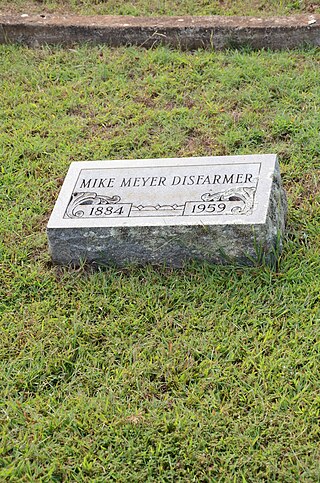
The Mike Meyer Disfarmer Gravesite is a historic gravesite in the Heber Springs Cemetery, Heber Springs, Arkansas. The grave is marked by a simple granite marker, bearing the legend "Mike Meyer Disfarmer / 1884–1959", with an egg-and-dart pattern in the bottom center between the dates, and a floral design above each of the dates. It is the only known surviving place associated with Mike Disfarmer, a noted regional portrait photographer. Disfarmer had his studio in Heber Springs, and photographed mainly local subjects. His work was the subject of a major retrospective in New York City in 1976.

Brearley Cemetery, founded in 1847, is the oldest cemetery in the city of Dardanelle, Arkansas. It is located on the north side of Arkansas Highway 27, west of its junction with Arkansas Highway 22. The cemetery, still in active use, houses more than 2,000 burials, many of the descendants of the early Czech immigrants to the area. One marker, possibly a memorial marker, bears the date 1780, but its provenance and significance has not been established. A 15-acre (6.1 ha) section on the eastern side of the cemetery, where its oldest burials are located, was listed on the National Register of Historic Places in 2007.
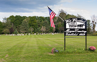
The Morgan West Wheatland Cemetery is a cemetery located on 55th Avenue between 10 & 11 Mile Roads in Wheatland Township, Mecosta County, Michigan. It was listed on the National Register of Historic Places in 2014.

The Hardin County Home Historic District, also known as Hardin County Poor Farm, Hardin County Farm, and the Hardin County Care Facility, is a nationally recognized historic district located northwest of Eldora, Iowa, United States. It was listed on the National Register of Historic Places in 2010. At the time of its nomination the district consisted of six resources, including three contributing buildings, one contributing site, and two non-contributing buildings. Beginning in the mid-19th century county homes were established across the state to take care of less fortunate residents. That care then extended to the end of the 20th century. The Hardin County Home operated at this location from 1877 to 1996. The historic district encompasses the buildings, farm fields, and cemetery associated with the home. The first burial in the cemetery, located on the southwest corner of the property, was in 1877. The graves are marked with simple stone markers. The last burial was in 2008. Farm fields surround the buildings and extend to the north.

Elmwood Cemetery, also known historically as the Poor Farm Cemetery, is a historic cemetery at Zero and South 24th Streets in Fort Smith, Arkansas. Established in 1891, it is on the grounds of Sebastian County's first poor farm, purchased by the county in 1890. It remained in use at least into the 1940s, and is the only surviving visible element of the poor farm. The cemetery contains several hundred graves, although only seven have markers. The cemetery is about 5 acres (2.0 ha) in size, and is an unbounded open field in a suburban residential area.


