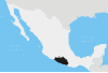
Guerrero, officially the Free and Sovereign State of Guerrero, is one of the 32 states which comprise the 32 Federal Entities of Mexico. It is divided in 81 municipalities and its capital city is Chilpancingo and its largest city is Acapulco. It is located in Southwestern Mexico. It is bordered by the states of Michoacán to the north and west, the State of Mexico and Morelos to the north, Puebla to the northeast and Oaxaca to the east. In addition to the capital city, the state's largest cities include Acapulco, Petatlán, Ciudad Altamirano, Taxco, Iguala, Ixtapa, Zihuatanejo, and Santo Domingo. Today, it is home to a number of indigenous communities, including the Nahuas, Mixtecs, Tlapanecs, Amuzgos, and formerly Cuitlatecs. It is also home to communities of Afro-Mexicans in the Costa Chica region.
Villa Guerrero is a town and municipality in the State of Mexico, Mexico. It is located on the southern slopes of the Nevado de Toluca, also known as Xinantecatl, and is 50 minutes/58 km from Toluca.

Tlatlaya is a small town and municipality located in the southeast of the State of Mexico in Mexico. The word “Tlatlaya” means when the hearth is black and red.
Texcaltitlán is a town and a municipality of the State of Mexico in Mexico. It is located 65 km from Toluca on the high plains south of the Nevado de Toluca volcano. The name Texcaltitlán comes from the Nahuatl: texcalli = “rock”; titla= "among", with the complete meaning as “among rocks”.
Tejupilco is a municipality in the State of Mexico, Mexico, located approximately 100 kilometres (62 mi) southwest of the state capital Toluca, along Federal Highway 34. Its municipal seat is Tejupilco de Hidalgo. The municipality has a total area of about 1,327 km2 (512 sq mi), with a contrasting topography ranging from deep ravines and canyons to high ridges; the highest elevation within the municipality reaches some 1,117 metres (3,660 ft) asl. The 2005 census recorded a population of 62,547 inhabitants.
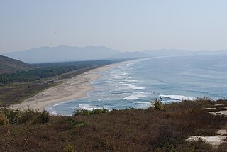
Costa Grande of Guerrero is a sociopolitical region located in the Mexican state of Guerrero, along the Pacific Coast. It makes up 325 km (202 mi) of Guerrero's approximately 500 km (311 mi) coastline, extending from the Michoacán border to the Acapulco area, wedged between the Sierra Madre del Sur and the Pacific Ocean. Acapulco is often considered part of the Costa Grande; however, the government of the state classifies the area around the city as a separate region. The Costa Grande roughly correlates to the Cihuatlán province of the Aztec Empire, which was conquered between 1497 and 1504. Before then, much of the area belonged to a dominion under the control of the Cuitlatecs, but efforts by both the Purépecha Empire and Aztec Empire to expand into this area in the 15th century brought this to an end. Before the colonial period, the area had always been sparsely populated with widely dispersed settlements. The arrival of the Aztecs caused many to flee and the later arrival of the Spanish had the same effect. For this reason, there are few archeological remains; however, recent work especially at La Soledad de Maciel has indicated that the cultures here are more important than previously thought. Today, the area economically is heavily dependent on agriculture, livestock, fishing and forestry, with only Zihuatanejo and Ixtapa with significantly developed infrastructure for tourism. The rest of the coast has been developed spottily, despite some government efforts to promote the area.

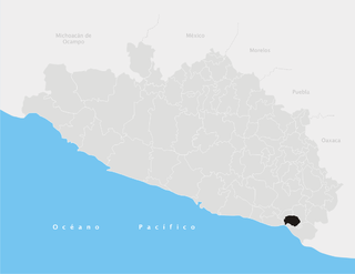
Petatlán is a city in Petatlán Municipality located along the Pacific Coast of the state of Guerrero in Mexico. It is part of the Costa Grande region between Zihuatanejo and Acapulco. The city is known for the Sanctuary of the Padre Jesús de Petatlán, a 17th-century image of Christ that is claimed to have performed religious miracles. The city is the seat of a large municipality, which faces the Pacific Ocean to the south and is bounded by the Sierra Madre del Sur to the north. It contains the La Soledad de Maciel archeological site. The area's recent history has been marked by violence related to the drug trade and to struggles between business and local farmers and environmental groups. St. Peter, Minnesota is a sister city of Petatlán.
Chichihualco is a city in the south of Mexico. It forms the administrative centre of the municipality of Leonardo Bravo, found in the centre of Guerrero state about 21 kilometres northwest of the state capital, Chilpancingo.

Atoyac de Álvarez is one of the 81 municipalities of Guerrero, in south-western Mexico. The municipal seat lies at Atoyac de Álvarez. The municipality covers an area of 1638.4 km².

Iliatenco is one of the 81 municipalities of Guerrero, in south-western Mexico. The municipal seat lies at Iliatenco. In 2005, the municipality had a total population of 10,039 and is the newest of municipalities in Guerrero, formed in 2005
Juchitán is one of the 81 municipalities of Guerrero, in south-western Mexico. The municipal seat lies at Juchitán. Founded in 2004, it is one of the newest municipalities in Guerrero.

San Luis Acatlán is one of the 81 municipalities of Guerrero, in south-western Mexico. The municipal seat lies at San Luis Acatlán. The municipality covers an area of 704.4 km².

Tixtla de Guerrero is one of the 81 municipalities of Guerrero, in south-western Mexico. The municipal seat lies at Tixtla de Guerrero. The municipality covers an area of 290 square kilometres (110 sq mi).
Florencio Villarreal is one of the 81 municipalities of Guerrero, in south-western Mexico. The municipal seat lies at Cruz Grande. The municipality covers an area of 372.9 km². It is named after Col. Florencio Villarreal, who drafted the 1854 Plan of Ayutla that ousted the conservative dictator Antonio López de Santa Anna. Ousting Santa Anna initiated a new era in Mexican politics with the liberals in charge, known as La Reforma. Leaders in Guerrero took the lead in rebelling against Santa Anna's government.
Malinaltepec is one of the 81 municipalities of Guerrero, in south-western Mexico. The municipal seat lies at Malinaltepec. The municipality covers an area of 492 km².
Petatlán Municipality is one of the 81 municipalities of Guerrero, in south-western Mexico. The municipal seat lies at Petatlán. The municipality covers an area of 2,071.7 km².
Pilcaya is one of the 81 municipalities of Guerrero, in south-western Mexico. The municipal seat lies at Pilcaya. The municipality covers an area of 62.1 km².

Tecpan de Galeana is one of the 81 municipalities of Guerrero, in south-western Mexico. The municipal seat lies at Tecpan de Galeana. The municipality covers an area of 2,537.8 km2 (979.9 sq mi).
Xochistlahuaca Municipality is one of the 81 municipalities of Guerrero, in south-western Mexico. The municipal seat lies at Xochistlahuaca. The municipality covers an area of 321.1 km².
Cochoapa el Grande is a city and is the seat of the municipality of Cochoapa el Grande, in the state of Guerrero, south-western Mexico.