The National Register of Historic Places (NRHP) is the United States federal government's official list of districts, sites, buildings, structures, and objects deemed worthy of preservation for their historical significance or "great artistic value". A property listed in the National Register, or located within a National Register Historic District, may qualify for tax incentives derived from the total value of expenses incurred in preserving the property.

This is a list of sites in Minnesota which are included in the National Register of Historic Places. There are more than 1,700 properties and historic districts listed on the NRHP; each of Minnesota's 87 counties has at least 2 listings. Twenty-two sites are also National Historic Landmarks.

Pottersville is an unincorporated community and census-designated place (CDP) split between Bedminster Township in Somerset County and Tewksbury Township in Hunterdon County, in the U.S. state of New Jersey. The area is served as United States Postal Service ZIP Code 07979. As of the 2010 United States Census, the population for ZIP Code Tabulation Area 07979 was 589. In 1990, most of the village was listed on the National Register of Historic Places as the Pottersville Village Historic District.
The history of the National Register of Historic Places began in 1966 when the United States government passed the National Historic Preservation Act (NHPA), which created the National Register of Historic Places (NRHP). Upon its inception, the U.S. National Park Service (NPS) became the lead agency for the Register. The Register has continued to grow through two reorganizations, one in the 1970s and one in 1980s and in 1978 the NRHP was completely transferred away from the National Park Service, it was again transmitted to the NPS in 1981.
The Keeper of the Register is a National Park Service (NPS) official, responsible for deciding on the eligibility of historic properties for inclusion on the U.S. National Register of Historic Places (NRHP).

The following properties in Newton, Massachusetts are listed on the National Register of Historic Places. They are a subset of all properties in Middlesex County. There are over 180 places listed in Newton.
Jewell is an unincorporated community in Warren County, Georgia, United States. It lies along Georgia Piedmont Scenic Byway State Route 16 to the southwest of the city of Warrenton, the county seat of Warren County. Jewell's elevation is 420 feet (128 m). It has a post office with the ZIP code 31045. It is by the Ogeechee River, which is the western border of Warren County at this point.

This is a list of the National Register of Historic Places listings in Dakota County, Minnesota. It is intended to be a complete list of the properties and districts on the National Register of Historic Places in Dakota County, Minnesota, United States. Dakota County is located in the southeastern part of the U.S. state of Minnesota, bounded on the northeast side by the Upper Mississippi River and on the northwest by the Minnesota River. The locations of National Register properties and districts for which the latitude and longitude coordinates are included below, may be seen in an online map.
Rockland is an unincorporated community in northern New Castle County, Delaware, United States. It lies along Rockland Road north of the city of Wilmington, the county seat of New Castle County. Its elevation is 194 feet (59 m). It has a post office with the ZIP code of 19732. The Rockland Historic District and William Young House are listed on the National Register of Historic Places. Other landmarks Woodley Park and Mount Lebanon United Methodist Church.

This list is of the properties and historic districts which are designated on the National Register of Historic Places or that were formerly so designated, in Hennepin County, Minnesota; there are 190 entries as of April 2023. A significant number of these properties are a result of the establishment of Fort Snelling, the development of water power at Saint Anthony Falls, and the thriving city of Minneapolis that developed around the falls. Many historic sites outside the Minneapolis city limits are associated with pioneers who established missions, farms, and schools in areas that are now suburbs in that metropolitan area.

This is a list of the National Register of Historic Places listings in Monterey County, California.
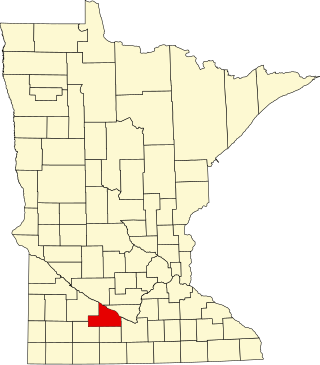
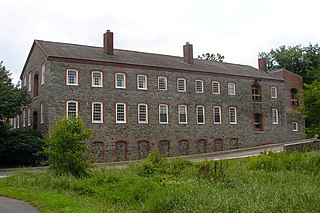
This is a list of the National Register of Historic Places listings in Brown County, Minnesota. It is intended to be a complete list of the properties and districts on the National Register of Historic Places in Brown County, Minnesota, United States. The locations of National Register properties and districts for which the latitude and longitude coordinates are included below, may be seen in an online map.

This is a list of the National Register of Historic Places listings in Morrison County, Minnesota. It is intended to be a complete list of the properties and districts on the National Register of Historic Places in Morrison County, Minnesota, United States. The locations of National Register properties and districts for which the latitude and longitude coordinates are included below, may be seen in an online map.

This is a list of the National Register of Historic Places listings in Henrico County, Virginia.

This is a list of the National Register of Historic Places listings in Prince William County, Virginia.

Spencertown is a hamlet in the town of Austerlitz, Columbia County, New York, United States. Its ZIP code is 12165.

Little York is an unincorporated community located along the border of Alexandria and Holland townships in Hunterdon County, New Jersey, United States. Little York is located on County Route 614 3.1 miles (5.0 km) north-northeast of Milford. Little York has a post office with ZIP code 08834.

Wallpack Center is an unincorporated community located within Walpack Township, Sussex County, New Jersey, United States. Wallpack Center is located in the Flat Brook Valley 6.7 miles (10.8 km) west of Branchville. Wallpack Center has a post office with ZIP code 07881. It is now part of the Delaware Water Gap National Recreation Area.

