Coffeeville, Alabama | |
---|---|
Coordinates: 31°45′29″N88°05′23″W / 31.75806°N 88.08972°W | |
Country | United States |
State | Alabama |
County | Clarke |
Area | |
• Total | 4.52 sq mi (11.71 km2) |
• Land | 4.52 sq mi (11.71 km2) |
• Water | 0.00 sq mi (0.00 km2) |
Elevation | 174 ft (53 m) |
Population (2020) | |
• Total | 263 |
• Density | 58.19/sq mi (22.47/km2) |
Time zone | UTC-6 (Central (CST)) |
• Summer (DST) | UTC-5 (CDT) |
ZIP code | 36524 |
Area code | 251 |
FIPS code | 01-16264 |
GNIS feature ID | 116356 [2] |
Website | https://www.townofcoffeeville.org/ |
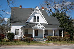
Coffeeville is a town in Clarke County, Alabama, United States. [2] At the 2020 census, the population was 263.
The town of Coffeeville was incorporated in 1817, and named after General John Coffee. [3] [4]
In 1892, Coffeeville was the site for a violent confrontation around economic and racial divides that later became known as the Mitcham War. [5] [6]
In 1939, racial violence in Coffeeville was brought to the attention of President Franklin D. Roosevelt following a near-lynching incident involving the complicity of the mayor of Coffeeville. [7]
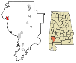
Coffeeville is located in northwestern Clarke County, on high ground on the east side of the Tombigbee River.
According to the U.S. Census Bureau, the town has a total area of 4.5 square miles (11.7 km2), all land. [8]
Census | Pop. | Note | %± |
---|---|---|---|
1870 | 280 | — | |
1880 | 104 | −62.9% | |
1940 | 250 | — | |
1950 | 211 | −15.6% | |
1960 | 250 | 18.5% | |
1970 | 441 | 76.4% | |
1980 | 448 | 1.6% | |
1990 | 431 | −3.8% | |
2000 | 360 | −16.5% | |
2010 | 352 | −2.2% | |
2020 | 263 | −25.3% | |
U.S. Decennial Census [9] 2013 Estimate [10] |
As of the census [11] of 2000, there were 360 people, 165 households, and 97 families residing in the town. The population density was 79.7 inhabitants per square mile (30.8/km2). There were 209 housing units at an average density of 46.3 per square mile (17.9/km2). The racial makeup of the town was 61.11% White and 38.89% Black or African American.
There were 165 households, out of which 22.4% had children under the age of 18 living with them, 40.6% were married couples living together, 13.9% had a female householder with no husband present, and 41.2% were non-families. 40.6% of all households were made up of individuals, and 21.2% had someone living alone who was 65 years of age or older. The average household size was 2.18 and the average family size was 2.95.
In the town, the population was spread out, with 23.9% under the age of 18, 6.9% from 18 to 24, 23.1% from 25 to 44, 25.3% from 45 to 64, and 20.8% who were 65 years of age or older. The median age was 42 years. For every 100 females, there were 80.9 males. For every 100 females age 18 and over, there were 80.3 males.
The median income for a household in the town was $19,545, and the median income for a family was $33,125. Males had a median income of $29,000 versus $17,500 for females. The per capita income for the town was $16,886. About 18.8% of families and 25.6% of the population were below the poverty line, including 42.2% of those under age 18 and 19.7% of those age 65 or over.
Chambers County is a county located in the east central portion of the U.S. state of Alabama. As of the 2020 census the population was 34,772. Its county seat is LaFayette. Its largest city is Valley. Its name is in honor of Henry H. Chambers, who served as a United States Senator from Alabama.
Clarke County is a county located in the southwestern part of the U.S. state of Alabama. As of the 2020 census, the population was 23,087. The county seat is Grove Hill. The county's largest city is Jackson. The county was created by the legislature of the Mississippi Territory in 1812. It is named in honor of General John Clarke of Georgia, who was later elected governor of that state.
Macon County is a county located in the east central part of the U.S. state of Alabama. As of the 2020 census, the population was 19,532. Its county seat is Tuskegee. Its name is in honor of Nathaniel Macon, a member of the United States Senate from North Carolina.
Midway is a town located in eastern Bullock County, Alabama, United States. At the 2020 census, the population was 421.
Fulton is a town in Clarke County, Alabama, United States. At the 2020 census, the population was 223.
Jackson is a city in Clarke County, Alabama, United States. The population was 4,748 at the 2020 census. It was one of three wet settlements in an otherwise-dry county.
Sylvania is a town in DeKalb County, Alabama, United States. It incorporated in October 1967. At the 2010 census the population was 1,837, up from 1,186 in 2000. Sylvania is located atop Sand Mountain. Sylvania was incorporated in 1967. The post office /town hall was built in 1977.
Webb is a town in Houston County, Alabama, United States. It is named for plantation owner B. F. Webb, who settled in the area around 1890. The town was incorporated in 1903. It is part of the Dothan, Alabama Metropolitan Statistical Area. As of the 2010 census, the population was 1,430, up from 1,298 in 2000.
Killen is a town in Lauderdale County, Alabama, United States. It is part of the Florence - Muscle Shoals Metropolitan Statistical Area known as "The Shoals". It was incorporated in 1957. As of the 2020 census, the population of the town is 1,034, down from its record high of 1,119 in 2000.
Gordonville is a town in Lowndes County, Alabama, United States. At the 2010 census the population was 326, up from 318 in 2000. It is part of the Montgomery Metropolitan Statistical Area. It incorporated effective January 20, 1990.
Franklin is a rural town in Macon County, Alabama, United States. As of the 2020 census, the population was 590.
Shorter is a town in Macon County, Alabama, United States. At the 2020 census the population was 385, down from 474 at the 2010 census. According to the 1990 U.S. Census records, it was incorporated in 1984.
Trinity is a town in Morgan County, Alabama, United States. It is included in the Decatur Metropolitan Area and the Huntsville-Decatur Combined Statistical Area. As of the 2020 census, the population of the town was 2,526, up from 2,095 in 2010. It was incorporated in 1901.
Pelham is a city in Shelby County, Alabama, United States. The population was 24,318 at the 2020 census, It incorporated on July 10, 1964 and is a suburb located in the Birmingham metropolitan area, Alabama which was home to nearly 1.2 million residents as of the 2020 census. It was named for Confederate Civil War officer John Pelham.
Margaret is a city in St. Clair County, Alabama, United States. At the 2020 census, the population was 5,106. As of the 2010 census, the population is 4,428, an increase of 278.8%. Margaret incorporated in 1960 and became a city in October 2011.
Camp Hill is a town in Tallapoosa County, Alabama, United States. It was incorporated in 1895. At the 2010 census the population was 1,014, down from 1,273 in 2000. Camp Hill is the home to Southern Preparatory Academy.
Coffeeville is a town in and one of two county seats of Yalobusha County, Mississippi, United States. The population was 905 at the 2010 census. It is named after John Coffee (1772–1833), a planter and military leader. The minor American Civil War Battle of Coffeeville took place near here in December 1862.
Tillatoba is a town in Yalobusha County, Mississippi, United States. The population was 91 at the 2010 census.
Ashton is a city in eastern Spink County, South Dakota, United States. The population was 108 at the 2020 census.
Cheriton is a town in Northampton County, Virginia, United States. The population was 486 at the 2020 census.