
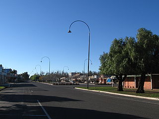
Corryong is a small town in Victoria, Australia 120 kilometres (75 mi) east of Albury-Wodonga, near the upper reaches of the Murray River and close to the New South Wales border. At the 2016 census, Corryong had a population of 1,348.
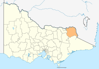
The Shire of Towong is a local government area in the Hume region of Victoria, Australia, located in the north-east part of the state. It covers an area of 6,675 square kilometres (2,577 sq mi) and in June 2018 had a population of 6,054.
Murray Valley Highway is a 663-kilometre (412 mi) state highway located in Victoria and New South Wales, Australia. The popular tourist route mostly follows the southern bank of the Murray River and effectively acts as the northernmost highway in Victoria. For all but the western end's last three kilometres, the highway is allocated route B400.

The electoral district of Benambra is one of the electoral districts of Victoria, Australia, for the Victorian Legislative Assembly. It covers an area of 10,037 square kilometres (3,875 sq mi) in north-eastern Victoria. The largest settlement is the city of Wodonga. Benambra also includes the towns of Baranduda, Barnawartha, Beechworth, Chiltern, Corryong, Eskdale, Kiewa, Mitta Mitta, Mount Beauty, Rutherglen, Tallangatta, Tangambalanga, Tawonga, Wahgunyah, and Yackandandah. It lies in the Northern Victoria Region of the upper house, the Legislative Council.
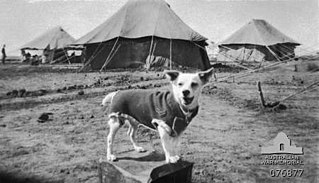
Horrie the Wog Dog was the unofficial mascot for the 2/1st Machine Gun Battalion of the Second Australian Imperial Force. An Egyptian terrier, the dog was befriended by a soldier serving in the unit when it was stationed in Egypt during the Second World War. The dog subsequently followed the battalion throughout various locations in the Middle East and in Greece and Crete, before being smuggled back to Australia in 1942. In 1945, the dog became the subject of a book by author Ion Idriess, and is believed to have been destroyed by quarantine officials, although this remains the subject of speculation with some researchers claiming that the dog survived after its owner switched it with another prior to destruction.
Walwa, is a town in the Shire of Towong in north east Victoria, Australia. The town is located 1 kilometre from the Murray River on the former Murray Valley highway between Wodonga and Corryong. At the 2016 census, the Walwa population had declined to just 177 having been 268 just ten years earlier.
Thomas Walter Mitchell was an Australian politician, author and sportsman.
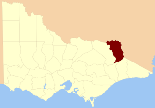
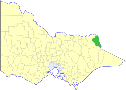
The County of Benambra is one of the 37 counties of Victoria which are part of the cadastral divisions of Australia, used for land titles. It is located between the Mitta Mitta River in the west, and the Murray River to the north and east. The town of Benambra is located near the southern edge. The area of the county roughly corresponds with the Electoral district of Benambra. Corryong is the largest town in the county. The county was proclaimed in 1871.

The Shire of Tallangatta was a local government area about 340 kilometres (211 mi) northeast of Melbourne, the state capital of Victoria, Australia. The shire covered an area of 4,090.72 square kilometres (1,579.4 sq mi), and existed from 1869 until 1994.
The Shire of Upper Murray was a local government area about 400 kilometres (249 mi) northeast of Melbourne, the state capital of Victoria, Australia. The shire covered an area of 2,459.81 square kilometres (949.7 sq mi), and existed from 1920 until 1994.

The High Country Rail Trail is a 35 kilometre, part-gravel part-sealed rail trail on the northern border of Victoria, Australia. It runs along the former Cudgewa railway line from Wodonga, along the edge of Lake Hume, to Shelley railway station in the former township of Shelley, Victoria. The eight kilometre section east from Tallangatta to Old Tallangatta is sealed; the remainining sections are not sealed but are accessible on hybrid, gravel, or mountain bikes.

The Upper Murray Football Netball League(UMFNL) is an Australian Rules Football and Netball competition based in the rural town of Corryong, Victoria, Australia. The league contains four clubs from around the townships & farming districts of the greater Upper Murray area, including the three founding clubs from 1893.

The Corryong Football Netball Club is an Australian rules football and netball club that plays in the Upper Murray Football League. The club fields all senior and junior sides alongside the Corryong Netball Club. Their players are mainly from the Corryong area and also from Albury/Wodonga.

Towong is a bounded rural locality of the Shire of Towong local government area in Victoria, Australia. Towong is on the Murray River close to Corryong.

The Federal Football Netball Club was an Australian rules football and netball club in the Upper Murray Football League, the club is known as the Swans based in Corryong, Victoria. It fields all senior and junior sides as well as a netball club. The club is also notable for producing Australian Football League (AFL) players including Carlton premiership player Adrian Whitehead. The club went into recess after the end of the 2022 season.
The Cobberas Range, a mountain range that is part of the Great Dividing Range within the Victorian Alps, is located in north-eastern Victoria in Australia. The range is located in the Cobberas Wilderness area of the Alpine National Park.
The Gibbo River, a perennial river of the North-East Murray catchment of the Murray-Darling basin, is located in the Alpine and East Gippsland regions of Victoria, Australia. It flows from the northwestern slopes of the Australian Alps, south and joins with Morass Creek southeast of Lake Dartmouth.
The Corryong Courier is a newspaper published in Corryong, Victoria, Australia
Colac Colac is a locality in the Hume region of the Australian state of Victoria. It is adjacent to the Murray Valley Highway, 8 kilometres (5.0 mi) southwest of Corryong.
