
John Adrian Louis Hope, 1st Marquess of Linlithgow, 7th Earl of Hopetoun, was a British aristocrat and statesman who served as the first governor-general of Australia, in office from 1901 to 1902. He was previously Governor of Victoria from 1889 to 1895.

The Shire of Yarriambiack is a local government area of Victoria, Australia, located in the north-western part of the state. It covers an area of 7,326 square kilometres (2,829 sq mi) and, in June 2018, had a population of 6,658, having fallen from 7,438 in 2008. It includes the towns of Hopetoun, Murtoa, Rupanyup and Warracknabeal. It was formed in 1995 from the amalgamation of the Shire of Warracknabeal, Shire of Karkarooc, and parts of the Shire of Dunmunkle and Shire of Wimmera.

Hopetoun is a town which serves as the major service centre for the Southern Mallee area of Victoria, Australia. Hopetoun is situated 400 km (249 mi) north-west of Melbourne on the Henty Highway in the Shire of Yarriambiack. In the 2016 census, Hopetoun had a population of 739.

The Yarriambiack Creek, an inland intermittent watercourse of the Wimmera catchment, is located in the Wimmera region of the Australian state of Victoria. Rising on the northern slopes of the Great Dividing Range, the Yarriambiack Creek flows generally north and drains into Lake Coorong, one of a series of ephemeral lakes, northeast of Hopetoun.

"Victoria (Australia)" is an invalid category parameter for Template:Coord missing.
The problem is usually caused either by a spelling mistake or by an-over-precise category.
For a full list of categories, see Category:Unclassified articles missing geocoordinate data and its subcategories.
The following lists events that happened during 1901 in Australia.
The following lists events that happened during 1900 in Australia.

Mildura is an electoral district of the Legislative Assembly in the Australian state of Victoria and sits within the Northern Victoria electorate. It is a 37,529 km2 rural electorate in the far-north-west of the state, encompassing the regional towns of Hopetoun, Mildura, Ouyen, Red Cliffs and Robinvale.

The Hopetoun Falls is a waterfall across the Aire River that is located in the Otways region of Victoria, Australia.

The Shire of Bacchus Marsh was a local government area about 50 kilometres (31 mi) west of Melbourne, the state capital of Victoria, Australia. The shire covered an area of 565 square kilometres (218.1 sq mi), and existed from 1862 until 1994.
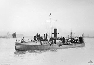
HMVS Countess of Hopetoun was a 1st Class Torpedo Boat of the Victorian Naval Forces, Commonwealth Naval Forces and the Royal Australian Navy. She was named after Hersey, Countess of Hopetoun and later Marchioness of Linlithgow, the wife of the 7th Earl of Hopetoun, the then Governor of Victoria and later the first Governor-General of Australia.
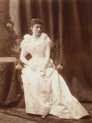
Hersey Alice Hope, Marchioness of Linlithgow was a British aristocrat, who was the wife of John Hope, 1st Marquess of Linlithgow, who, as the 7th Earl of Hopetoun, was the first Governor-General of Australia 1901-1902.

Brim is a small town in the Wimmera region of Victoria, Australia. The town is located 359 kilometres (223 mi) north west of the state capital, Melbourne on the Henty Highway. It is on the banks of the Yarriambiack Creek. It is in the Shire of Yarriambiack local government area. At the 2016 census, Brim had a population of 171.

The Aire River is a perennial river of the Corangamite catchment, located in the Otways region of the Australian state of Victoria.
Lake Coorong is an eutrophic lake located in the Wimmera region of western Victoria, Australia. The lake is located adjacent to the township of Hopetoun. After more than a decade of drought, in early 2011 the lake filled as a result of flooding in the region.

The Warkawarka, also called Weki Weki, were an Australian Aboriginal group whose traditional lands are located in Victoria, Australia. Controversy exists as to whether they were an independent 'tribe' or rather consisted of a subgroup of the Wergaia, the latter view being shared by both Robert M. W. Dixon and Luise Hercus.

Hopetoun Park is a rural residential suburb of Bacchus Marsh, a peri-urban town in central Victoria, Australia. The locality consists of the area between the Bacchus Marsh urban area and Melton, north of the Werribee River and south of the Western Highway. It is in the Shire of Moorabool, 51 kilometres (32 mi) west north west of the state capital, Melbourne.

The County of Hopetoun is one of the 49 counties of South Australia on the state's west coast. It was proclaimed in 1892 by Governor Algernon Keith-Falconer and named for John Hope then the Governor of Victoria.
