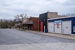
Creighton, Missouri

Last updated

Creighton, Missouri
Cass County Missouri Incorporated and Unincorporated areas Creighton Highlighted.svg
Location of Creighton, Missouri
Coordinates: 38°29′48″N94°04′20″W / 38.49667°N 94.07222°W / 38.49667; -94.07222
Country United States
State Missouri
County Cass
Area
[1]
  Total0.34 sq mi (0.89 km2)
  Land0.34 sq mi (0.89 km2)
  Water0.00 sq mi (0.00 km2)
Elevation
[2]
801 ft (244 m)
Population
 (2020)
  Total327
  Density947.83/sq mi (366.04/km2)
Time zone UTC-6 (Central (CST))
  Summer (DST) UTC-5 (CDT)
ZIP code
64739 [3]
Area code 660
FIPS code 29-17164 [4]
GNIS feature ID2393667 [2]

Creighton is a city in Cass County, Missouri, United States. The population was 327 at the 2020 census. It is 57 miles south southeast of the Kansas City metropolitan area.

Contents

Community

History

Creighton was platted in 1855, and named after John B. Creighton, a pioneer citizen. [5] A post office called Creighton has been in operation since 1887. [6]

Geography

According to the United States Census Bureau, the city has a total area of 0.35 square miles (0.91 km2), all land. [7]

Demographics

Historical population
CensusPop.Note
1890 308
1900 36016.9%
1910 40011.1%
1920 335−16.2%
1930 289−13.7%
1940 272−5.9%
1950 269−1.1%
1960 228−15.2%
1970 29428.9%
1980 3012.4%
1990 289−4.0%
2000 32211.4%
2010 3498.4%
2020 327−6.3%
U.S. Decennial Census [8]

2020 census

As of the census [9] of 2020, there were 327 people, 139 households, and 94 families living in the city. The population density was 997.1 inhabitants per square mile (385.0/km2). There were 143 housing units at an average density of 457.1 per square mile (176.5/km2). The racial makeup of the city was 91.7% White, 1.2% African American, .6% Native Hawaiian or Pacific Islander,1.7% Native American, and 5.5% from two or more races. Hispanic or Latino of any race were 3.9% of the population.

There were 139 households, of which 20.9% had children under the age of 18 living with them, 38.1% were married couples living together, 30.2% had a female householder with no husband present, 19.4% had a male householder with no wife present, and 12.3% were non-families. 29.6% of all households were made up of individuals, and 11.3% had someone living alone who was 65 years of age or older. The average household size was 2.46 and the average family size was 3.02.

The median age in the city was 35.2 years. 20.9% of residents were under the age of 18; 13.3% were between the ages of 18 and 24; 14.6% were from 25 to 44; 26.9% were from 45 to 64; and 14.7% were 65 years of age or older. The gender makeup of the city was 46.4% male and 53.6% female.

2010 census

As of the census [9] of 2010, there were 349 people, 142 households, and 94 families living in the city. The population density was 997.1 inhabitants per square mile (385.0/km2). There were 160 housing units at an average density of 457.1 per square mile (176.5/km2). The racial makeup of the city was 95.7% White, 2.0% African American, 1.7% Native American, and 0.6% from two or more races. Hispanic or Latino of any race were 2.0% of the population.

There were 142 households, of which 35.9% had children under the age of 18 living with them, 47.9% were married couples living together, 9.9% had a female householder with no husband present, 8.5% had a male householder with no wife present, and 33.8% were non-families. 29.6% of all households were made up of individuals, and 11.3% had someone living alone who was 65 years of age or older. The average household size was 2.46 and the average family size was 3.02.

The median age in the city was 33.9 years. 25.8% of residents were under the age of 18; 9.5% were between the ages of 18 and 24; 26.6% were from 25 to 44; 25.2% were from 45 to 64; and 12.9% were 65 years of age or older. The gender makeup of the city was 48.7% male and 51.3% female.

2000 census

As of the census [4] of 2000, there were 322 people, 128 households, and 83 families living in the city. The population density was 1,086.7 inhabitants per square mile (419.6/km2). There were 138 housing units at an average density of 465.7 per square mile (179.8/km2). The racial makeup of the city was 98.76% White, 0.31% from other races, and 0.93% from two or more races. Hispanic or Latino of any race were 0.62% of the population.

There were 128 households, out of which 38.3% had children under the age of 18 living with them, 53.1% were married couples living together, 8.6% had a female householder with no husband present, and 34.4% were non-families. 31.3% of all households were made up of individuals, and 17.2% had someone living alone who was 65 years of age or older. The average household size was 2.52 and the average family size was 3.17.

In the city the population was spread out, with 31.1% under the age of 18, 5.9% from 18 to 24, 32.3% from 25 to 44, 16.8% from 45 to 64, and 14.0% who were 65 years of age or older. The median age was 35 years. For every 100 females, there were 105.1 males. For every 100 females age 18 and over, there were 101.8 males.

The median income for a household in the city was $41,071, and the median income for a family was $48,750. Males had a median income of $41,000 versus $19,479 for females. The per capita income for the city was $20,369. About 8.9% of families and 12.9% of the population were below the poverty line, including 11.7% of those under age 18 and 19.5% of those age 65 or over.

Related Research Articles

<span class="mw-page-title-main">Bosworth, Missouri</span> City in Missouri, United States

Bosworth is a city in Carroll County, Missouri, United States. The population was 213 at the 2020 U.S. Census.

<span class="mw-page-title-main">St. Martins, Missouri</span> City in Missouri, United States

St. Martins or Saint Martins is a city in Cole County, Missouri, United States. The population was 1,191 at the 2020 census. It is part of the Jefferson City, Missouri Metropolitan Statistical Area.

<span class="mw-page-title-main">Cainsville, Missouri</span> City in Missouri, United States

Cainsville is a city in eastern Harrison County, Missouri, United States. The population was 283 at the 2020 census.

<span class="mw-page-title-main">Deepwater, Missouri</span> City in Missouri, United States

Deepwater is a city in Henry County, Missouri, United States. The population was 433 at the 2010 census.

<span class="mw-page-title-main">Hawk Point, Missouri</span> City in Missouri, United States

Hawk Point is a city in Lincoln County, Missouri, United States. The population was 669 at the 2010 census.

<span class="mw-page-title-main">Laurie, Missouri</span> City in Missouri, United States

Laurie is a city in southern Morgan and northern Camden counties, Missouri, United States. The population was 945 at the 2010 census.

<span class="mw-page-title-main">Pickering, Missouri</span> Village in Missouri, United States

Pickering is a city in Nodaway County, Missouri, United States. The population was 160 at the 2010 census.

<span class="mw-page-title-main">Homestown, Missouri</span> City in Missouri, United States

Homestown is a city in Pemiscot County, Missouri, United States. The population was 73 at the 2020 census.

<span class="mw-page-title-main">Tracy, Missouri</span> City in Missouri, United States

Tracy is a city in Platte County, Missouri within the United States, located along the Platte River. The population was 269 at the 2020 census. The city is part of the Kansas City metropolitan area.

<span class="mw-page-title-main">Henrietta, Missouri</span> City in Missouri, United States

Henrietta is a city in southern Ray County, Missouri, and part of the Kansas City metropolitan area within the United States. The population was 278 at the 2020 census.

<span class="mw-page-title-main">Malta Bend, Missouri</span> City in Missouri, United States

Malta Bend is a city in Saline County, Missouri, United States. The population was 250 at the 2010 census.

<span class="mw-page-title-main">Miami, Missouri</span> City in Missouri, United States

Miami is a city in Saline County, Missouri, United States. The population was 175 at the 2010 census.

<span class="mw-page-title-main">Crystal Lake Park, Missouri</span> City in Missouri, United States

Crystal Lake Park is a Missouri Class 4 city in St. Louis County, Missouri, United States. The population was 508 at the 2020 census.

<span class="mw-page-title-main">Greendale, Missouri</span> City in Missouri, United States

Greendale is a city in St. Louis County, Missouri, United States. The population was 651 at the 2010 census.

<span class="mw-page-title-main">Schell City, Missouri</span> City in Missouri, United States

Schell City is a city in northeast Vernon County, Missouri, United States. The population was 249 at the 2010 census.

<span class="mw-page-title-main">Creighton, Nebraska</span> City in Nebraska, United States

Creighton is a city in Knox County, Nebraska, United States. The population was 1,154 at the 2010 census.

<span class="mw-page-title-main">Fort Calhoun, Nebraska</span> City in Washington County, Nebraska, United States

Fort Calhoun is a city in Washington County, Nebraska, United States. The population was 1,108 at the 2020 census. The city includes Fort Atkinson, the first fort built west of the Missouri River.

<span class="mw-page-title-main">Clarkson Valley, Missouri</span> City in Missouri, United States

Clarkson Valley is a city in St. Louis County, Missouri, United States. The population was 2,609 at the 2020 census.

<span class="mw-page-title-main">Miner, Missouri</span> City in Missouri, United States

Miner is a city in Mississippi and Scott counties in the U.S. state of Missouri. It borders the city of Sikeston to the east. The population was 916 at the 2020 census.

<span class="mw-page-title-main">Dardenne Prairie, Missouri</span> Town in Missouri, United States

Dardenne Prairie is a city in St. Charles County, Missouri, United States. The population was 12,743 at the 2020 census.

References

  1. "ArcGIS REST Services Directory". United States Census Bureau. Retrieved August 28, 2022.
  2. 1 2 U.S. Geological Survey Geographic Names Information System: Creighton, Missouri
  3. "Creighton MO ZIP Code". zipdatamaps.com. 2023. Retrieved June 16, 2023.
  4. 1 2 "U.S. Census website". United States Census Bureau . Retrieved January 31, 2008.
  5. "Cass County Place Names, 1928–1945 (archived)". The State Historical Society of Missouri. Archived from the original on June 24, 2016. Retrieved September 16, 2016.{{cite web}}: CS1 maint: bot: original URL status unknown (link)
  6. "Post Offices". Jim Forte Postal History. Archived from the original on March 6, 2016. Retrieved September 16, 2016.
  7. "US Gazetteer files 2010". United States Census Bureau. Archived from the original on January 25, 2012. Retrieved July 8, 2012.
  8. "Census of Population and Housing". Census.gov. Retrieved November 3, 2021.
  9. 1 2 "U.S. Census website". United States Census Bureau . Retrieved November 3, 2021.