
The Otago Gold Rush was a gold rush that occurred during the 1860s in Central Otago, New Zealand. This was the country's biggest gold strike, and led to a rapid influx of foreign miners to the area – many of them veterans of other hunts for the precious metal in California and Victoria, Australia. The number of miners reached its maximum of 18,000 in February 1864.
Blackball is a small town on the West Coast of the South Island of New Zealand, approximately 29 km from Greymouth. Elevation is approximately 100 metres. The town was named after the Black Ball Shipping Line, which leased land in the area to mine for coal.

Reefton is a small town in the West Coast region of New Zealand, some 80 km northeast of Greymouth, in the Inangahua River valley. Ahaura is 44 km south-west of Reefton, Inangahua Junction is 34 km to the north, Maruia is 63 km to the east, and the Lewis Pass is 66 km to the south-east.

Inangahua is a small settlement in the northwest of New Zealand's South Island. It consists of three settled areas: Inangahua Junction at the confluence of the Inangahua and Buller Rivers, 34 kilometres (21 mi) north of Reefton and 46 kilometres (29 mi) southeast of Westport; Inangahua Landing, 10 km further up the Inangahua River; and Inangahua township, 2 km east of the Junction. Murchison is 52 kilometres (32 mi) further east. After the 1968 Inangahua Earthquake, most of the inhabitants left the area or shifted to the township, which is now the population centre and known simply as Inangahua.

Ross is a small town located in the Westland District on the West Coast of New Zealand's South Island, 27 kilometres (17 mi) south-west of Hokitika and 46 kilometres (29 mi) north-east of Hari Hari by road.
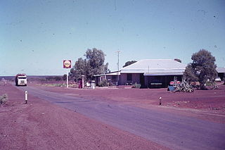
Paynes Find, also called Paynes, is a settlement approximately 430 kilometres (267 mi) northeast of Perth in the Mid West region of Western Australia. It is reachable by the Great Northern Highway. It was originally founded after the discovery of a gold bearing quartz vein; a roadhouse, a battery, and a few other buildings remain today. Alongside its fluctuating gold activity the area is known for its annual everlasting bloom, and sheep stations.

Charleston is a village in the South Island of New Zealand located 30 km south of Westport. It was founded as a goldmining town after a major goldrush in 1867, and is now an adventure tourist village noted for its extensive limestone caves and caving experiences. Guided tours of the nearby Metro Cave / Te Ananui Cave are operated out of Charleston and travel up the Waitakere / Nile River valley.

Waikino is a small settlement at the eastern end of a gorge in the North Island of New Zealand alongside the Ohinemuri River, between Waihi and the Karangahake Gorge. The Waikino district lies at the base of the ecologically sensitive Coromandel Peninsula with its subtropical rainforests, steep ravines and fast moving rivers and streams. The cascades of the Owharoa Falls lie just to the south west of the settlement.

Adelong is a small town in the Riverina region of New South Wales, Australia, on the banks of the Adelong Creek. Adelong sits on the Snowy Mountains Highway and is a part of the Snowy Valleys Council. At the 2016 census, Adelong had an urban population of 943.
Yalwal is the site of a former gold mining town of the same name situated 29 km (18 mi) west of Nowra at the confluence of the Danjera and Yarramunmun Creeks which then forms Yalwal Creek which flows into the Shoalhaven River in New South Wales, Australia.

Quartz reef mining is a type of gold mining in "reefs" (veins) of quartz. Quartz is one of the most common minerals in the Earth's crust, and most quartz veins do not carry gold, but those that have gold are avidly hunted by prospectors. In the shallow, oxidized zones of quartz reef deposits, the gold occurs in its metallic state, and is easily recovered with simple equipment. Quartz reef mining played an important role in 19th century gold-mining districts such as Bendigo, Victoria in Australia, Central Otago in New Zealand, and the California mother lode.

Lyell is the site of a historic gold mining town in the Buller Gorge in the South Island of New Zealand. It lies on State Highway 6, 18 km (11 mi) northeast of Inangahua.
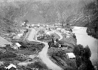
Waiuta is the location of a historic mining town on the West Coast of the South Island of New Zealand. It is now abandoned and considered a ghost town. Located 58 km north of Greymouth and 21 km south of Reefton in Ikamatua, New Zealand, it was the site of a gold mine until 1951, when the collapse of the mine made it uneconomic. A number of buildings remain and there are still residents in what remains of the town. Nowadays Waiuta has become a tourist attraction, with few of the original buildings still intact that include the former police station, three cottages and the old barber shop.

Bendigo is a settlement and historic area in Central Otago, South Island of New Zealand. It is located some 20 kilometres to the north of Cromwell, to the east of the head of Lake Dunstan, on the banks of the Bendigo Creek, a small tributary of the Clutha River.
The Coromandel Gold Rushes on the Coromandel Peninsula and around the nearby towns of Thames and Waihi in New Zealand in the nineteenth century were moderately successful. Traces of gold were found about 1842. A small find was made near Coromandel in 1852; and a larger find in August 1867 when there was a modest rush. But Thames acquired a reputation for speculative holding of unworked ground despite regulations designed to check it, and some miners left for Queensland. Most of the gold was in quartz reefs rather than in more accessible alluvial deposits and had to be recovered from underground mines and extracted using stamping batteries.

The Paparoa Track is a 55.7 km (34.6 mi) shared hiking and mountain biking track located in Paparoa National Park in the South Island of New Zealand. The track was created as a memorial for the 29 miners who lost their lives in the Pike River Mine disaster. The track is the tenth Great Walk to be created and has been fully open since 1 March 2020. It was the first addition to the Great Walks in 25 years.

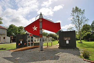
Blacks Point Museum is a museum in Blacks Point, near Reefton on the West Coast of the South Island of New Zealand.
Blacks Point is a locality near Reefton on the West Coast of the South Island of New Zealand.

The Croesus Track is a 22.1 km (13.7 mi) historic miners trail to the south of Paparoa National Park in the Grey District of South Island of New Zealand. The route crosses the Paparoa Range from Blackball in the Grey Valley to Barrytown on the Tasman Sea coast. The first section, starting from the Blackball end, is shared with the Paparoa Track which follows the route of the Croesus Track to top of the Paparoa Range. This section is shared-use between hiking and mountain biking.
The Bendigo Goldfields region of Central Otago is an historic area comprising several former mining settlements in the southern South Island of New Zealand. It was part of the Otago Gold Rush that occurred during the 1860s, leading to an influx of miners from rushes in California and Victoria, Australia. These miners brought with them a rich diversity of cultures from England, Scotland, Wales, Ireland, Sweden, China, Australia, Canada, and the United States. The area was named after the goldfield by the same name in Victoria.


