
The Lawton Mills Historic District in Plainfield, Connecticut encompasses a well-preserved early-20th-century mill village. The central focus of the district is the large brick mill complex to the south of Railroad Avenue on the banks of Horse Brook. The mill ownership developed the areas on either side of the mill complex with a substantial worker housing complex. The district includes more than 100 historically significant structures, most of which are worker house that has survived with generally only modest alterations. There are a few commercial buildings in the district, built to provide services to the works, and a community hall, which now serves as Plainfield's town hall. The district was listed on the National Register of Historic Places in 1996.
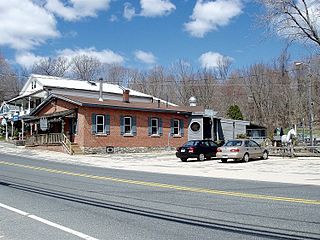
The South Coventry Historic District is a historic district encompassing the historic village center of South Coventry in the town of Coventry, Connecticut. The village, settled in the early 18th century, has served as Coventry's civic center, and also served as an economic center, with textile mills operating in the 19th century. The district was listed on the National Register of Historic Places in 1991.

The Branford Point Historic District is a historic district in Branford, Connecticut. It was listed on the National Register of Historic Places in 1988. It includes a significant portion of the Branford Point neighborhood, generally considered to be the area along the west side of the Branford Harbor to the Amtrak railroad tracks. It is bounded on the west by the Short Beach neighborhood, on the north by Branford Center, and on the east by the Branford River. Harbor Street, Maple Avenue, and Stannard Avenue are the main thoroughfares of the neighborhood. In the 2000 Census, Branford Point was included by the U.S. Census Bureau in the Branford Center census-designated place.

The Glastonbury-Rocky Hill Ferry Historic District is a historic district in Glastonbury and Rocky Hill, Connecticut, encompassing a landscape with more than 300 years of colonial and post-colonial history. It includes the ferry landings and water traversed by the Rocky Hill – Glastonbury Ferry, one of the longest-running ferry services the nation, and the surrounding farmscapes and ferry landing village. The district was listed on the National Register of Historic Places in 2005.

The South Glastonbury Historic District is a historic district in Glastonbury, Connecticut. It encompasses the historic village center of South Glastonbury, which was first settled in the 17th century. The district was listed on the National Register of Historic Places in 1984, and enlarged in 2009 to include properties further along Main Street as far as Chestnut Hill Road. Locals refer to it as Nayaug.
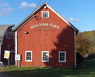
The West Granby Historic District is a historic district in Granby, Connecticut. It encompasses the historic village of West Granby, which extends along Simsbury Road between Firetown Road and Hartland Road. Although this area was settled in the 18th century, and has a few surviving buildings from that time, its most significant period of development was in the 19th century, when industry came to play a role in the area. The district was listed on the National Register of Historic Places in 1992.
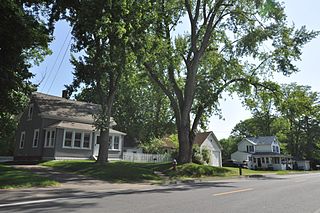
The Elm Street Historic District is a rural historic district in southern Hatfield, Massachusetts. It encompasses a landscape that has seen agricultural use since 17th century colonial days, including fields now used for tobacco farming, and historic properties located along five roads: Elm Street, Scotland Road, Sunset Road, Brook Hollow Road, and Little Neponset Road. The district is bounded on its south by the Connecticut River, on its east and north by the Mill River, with a small portion of land border in the northeast which cuts off a large meander in the river. This section, near the junction of Elm and Prospect Streets, is also where this district abuts the Mill-Prospect Street Historic District, which runs north along Prospect Street, and its eastern boundary abuts the Hatfield Center Historic District. Its western boundary is roughly a north-south line in the area of the junction of Elm and Dwight Streets.

The Hillside Historic District in Waterbury, Connecticut is a 106-acre (43 ha) historic district that was listed on the National Register of Historic Places (NRHP) in 1987. It encompasses a residential area north of the city's central business district, and is bounded on the south by West Main Street, the west by Willow Avenue and Cliff and Frederick Streets, on the north by Buckingham Street and Woodland Terrace, and on the east by Cook Street. Developed principally over an 80-year period between 1840 and 1920, it includes a cross-section of architectural styles of the 19th and early 20th centuries. The area was a desirable neighborhood of the city for much of this time, and was home to a number of the city's elite. In 1987, it included 395 buildings deemed to contribute to the historic character of the area, and one other contributing structure. It includes the Wilby High School and the Benedict-Miller House, which are both separately listed. 32 Hillside Road, a several acre property that includes the Benedict Miller House, was the original site of The University of Connecticut's Waterbury Branch until 2003.

The Hempstead Historic District of New London, Connecticut encompasses a residential area north of the city's harbor and central business district, extending mainly along three roughly parallel streets: Franklin and Hempstead Streets, and Mountain Avenue. The area was settled in the 17th century, and has three centuries of architecture depicting an increasingly urban area. The district was listed on the National Register of Historic Places on July 31, 1986.

The Granby Center Historic District is a predominantly residential historic district encompassing a portion of the village of Granby Center in Granby, Connecticut. The village developed in the 18th century as a farming center, and a now includes a variety of architectural styles from the late 18th to early 20th centuries. The district was listed on the National Register of Historic Places (NRHP) in 1985.

The Glastonbury Historic District encompasses a streetscape dating to the 17th century, along Main St. from Hebron Ave. to Talcott Rd. in Glastonbury, Connecticut. In addition to a significant number of 17th and 18th-century houses, it shows the architectural development of the town over time, with buildings spanning three centuries in construction dates. It was listed on the National Register of Historic Places in 1984.

The Brattleboro Downtown Historic District encompasses most of the central business district of the town of Brattleboro, Vermont. Extending along Main Street between Whetstone Brook and a junction with Pultney Road and Linden and Walnut Streets, this area includes many of the town's prominent civic and institutional buildings. The area's development took place primarily in the 19th century, with surviving buildings from both the 18th and early 20th centuries. The district was listed on the National Register of Historic Places in 1983, and was enlarged in 2004 to include Plaza Park and the Holstein Building on the south side of Whetstone Brook.

The Selden Brewer House is a historic house at Naubuc Avenue and Main Street in East Hartford, Connecticut. Built about 1827, it is a good local example of late Federal/early Greek Revival architecture. It was built and owned for many years by a prominent local tobacco-growing family. Originally located on High Street, it was moved to its present location in the 1980s, and now houses offices of the local historical society. It was listed on the National Register of Historic Places in 1979.
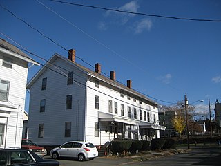
The Bigelow-Hartford Carpet Mills Historic District encompasses a company-built factory and residential area in the Thompsonville area of Enfield, Connecticut. In addition to the former factory buildings of the Bigelow-Hartford Carpet Mills, it includes more than 150 housing units built by the company between about 1830 and 1920. It is roughly bounded on the north by Lafayette Street and Alden Avenue, the east by Hartford Avenue and Lincoln Street, the south by High Street, and the west by River Street. It was listed on the National Register of Historic Places in 1994.

The Central Avenue-Center Cemetery Historic District encompasses part of the town center of East Hartford, Connecticut. Although it was founded in the mid-17th century, it is now dominated by architecture of the late 19th and early 20th centuries. The Center Cemetery is the town's oldest surviving property, and includes the grave of William Pitkin, a colonial governor. The district, including portions of Main Street and Central Avenue, was listed on the National Register of Historic Places in 1993.

The Abraham Coult House is a historic house at 1695 Hebron Avenue in Glastonbury, Connecticut. Built about 1706 and enlarged several times, it is a well-preserved colonial residence, exhibiting changing construction methods through its alterations. Moved in the 1970s to avoid demolition and restored, it was listed on the National Register of Historic Places in 2000.

The Lewis-Zukowski House is a historic house at 1095 South Grand Street in Suffield, Connecticut. Built in 1781, it is rare in the town as an 18th-century residence built out of brick, accompanied by a mid-19th century barn. It was listed on the National Register of Historic Places in 1990.

The Naubuc Avenue-Broad Street Historic District encompasses a largely agrarian village area of southwestern East Hartford, Connecticut. Extending along Naubuc Avenue from the Glastonbury line to Broad Street, and along Broad to Main Street, its architecture encapsulates the area's history between the 18th and early 20th centuries. It was listed on the National Register of Historic Places in 1998.

The Salmon Brook Historical Society is the local historical society of Granby, Connecticut. The society's museum property is located and 208 Salmon Brook Street, and includes four historic buildings, which include museum displays of historic items, and a small research library. Two of the buildings, the Rowe and Weed Houses, are listed as a pair on the National Register of Historic Places.

The Windsor Farms Historic District encompasses a large historically agricultural area and the historic town center of South Windsor, Connecticut. Its built environment extends mainly along Main Street, between Interstate 291 in the south and Strong Road in the north, with a diversity of architecture spanning three centuries. The district includes agricultural fields on both sides, many of which remain in tobacco cultivation. The district was listed on the National Register of Historic Places in 1986.





