
Stawell ( "stall"), is an Australian town in the Wimmera region of Victoria 237 kilometres (147 mi) west-north-west of the state capital, Melbourne. Located within the Shire of Northern Grampians local government area, it is a seat of local government for the shire and its main administrative centre. At the 2021 census, Stawell had a population of 6,220.

Mildura is a regional city in north-west Victoria, Australia. Located on the Victorian side of the Murray River, Mildura had a population of 34,565 in 2021. When nearby Wentworth, Irymple, Nichols Point, Merbein and Red Cliffs are included, the combined urban area had a population of 58,914 in 2021, having grown marginally at an average annual rate of 1.3% year-on-year over the preceding five years.

Narromine (/næroʊmaɪn/) is a rural Australian town located approximately 40 kilometres (25 mi) west of Dubbo in the Orana region of New South Wales. The town is at the centre of Narromine Shire. The 2016 census recorded a population of 3,528. Narromine holds strong historical ties to the Australian Military, as it was the location of RAAF No.19 Inland Aircraft Fuel Depot (IAFD) during World War II. The base contributed to the preparation of troops through a training organisation known as the Empire Air Training Scheme (EATS). The town was one of twelve locations for the No.5 Elementary Flying Training School RAAF in 1940.

Wentworth is a small border town in the far south west of the state of New South Wales, Australia. It lies at the confluence of Australia's two most important rivers, the Darling and the Murray, the latter forming the border with the state of Victoria to the south. The border with the state of South Australia lies approximately 100 kilometres (62 mi) to the west. The town of Wentworth is in the local government area of the same name.

Branxton is a town in the Hunter Region of New South Wales, Australia. Branxton is 171 kilometres (106 mi) north of Sydney via the Sydney–Newcastle Freeway and New England Highway. Branxton is located mostly in the City of Cessnock, but part of it is in Singleton Shire.

Walgett is a town in northern New South Wales, Australia, and the seat of Walgett Shire. It is near the junctions of the Barwon and Namoi Rivers and the Kamilaroi and Castlereagh Highways. In 2016, Walgett had a population of 2,145.
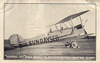
Sunraysia is a region located in northwestern Victoria and southwestern New South Wales in Australia. The region is renowned for its sunshine, intensive horticulture including grapes and oranges. Its main centre is Mildura, Victoria.

St Arnaud is a town in the Wimmera region of Victoria, Australia, 244 kilometres north west of the capital Melbourne. It is in the Shire of Northern Grampians local government area. At the 2021 census, St Arnaud had a population of 3,453.

Merbein is a town just north of Mildura, Victoria, in the Sunraysia region of Australia. It is on the Calder Highway between Mildura and the Murray River crossing at the Abbotsford Bridge to Curlwaa. At the 2016 census, the town had a population of 1,981. Merbein is 12 kilometres from Mildura, 553 km from Melbourne and 389 km from Adelaide.
Pambula is a town in Bega Valley Shire on the far south coast of New South Wales, Australia 454 kilometres (282 mi) south of Sydney via the Princes Highway. At the 2016 census, Pambula had a population of 970 people.

Leeton is a town located in the Riverina region of New South Wales, Australia. Leeton is situated in the Murrumbidgee Irrigation Area. It is the administrative centre of the Leeton Shire Council local government area, which includes neighbouring suburbs, towns and localities such as Yanco, Wamoon, Whitton, Gogeldrie, Stanbridge and Murrami. Situated in one of the most productive farming regions in the state, the town was designed by Walter Burley Griffin and purpose-built for the irrigation schemes announced by the New South Wales government in the early 20th century. The Leeton Shire possesses numerous citrus, rice, cotton, grape, walnut and wheat farms. Leeton is known as Australia's Rice Capital, as well as The Heart of SunRice Country, as it is home to the headquarters of SunRice corporation, one of Australia's largest food exporters. Other industry includes Arnott's Biscuits, the Daily Drinks Company, JBS Australia, Webster Limited, and Murrumbidgee Irrigation Limited. Tony Reneker is the current mayor of Leeton.
Wentworth Falls is a town in the Blue Mountains region of New South Wales, situated approximately 100 kilometres (62 mi) west of the Sydney central business district, and about 8 kilometres (5.0 mi) east of Katoomba, Australia on the Great Western Highway, with a Wentworth Falls railway station on the Main Western line. The town is at an elevation of 867 metres (2,844 ft) AHD . At the 2016 census, Wentworth Falls had a population of 6,076.

Barden Ridge is a suburb in southern Sydney, in the state of New South Wales, Australia. Barden Ridge is located 29 kilometres south of the Sydney central business district in the local government area of the Sutherland Shire. Barden Ridge is colloquially known to locals as 'The Ridge'.

Moss Vale is a town in the Southern Highlands of New South Wales, Australia, in the Wingecarribee Shire. It is located on the Illawarra Highway, which connects to Wollongong and the Illawarra coast via Macquarie Pass.

Grong Grong is a small town that is located in the Riverina region of New South Wales, Australia. The town is situated on the Newell Highway, 23 kilometres (14 mi) east of Narrandera in the Shire of Narrandera.
Gol Gol is a small town in the Wentworth Shire, in the far western region of New South Wales, Australia. It is situated on the banks of the Murray River, in the Sunraysia region. Increasingly, Gol Gol serves as a suburb of Mildura, being only 8 kilometres (5.0 mi) from that regional centre. In the fifteen years from 2006 to 2021, the population of Gol Gol increased from 663 to 1,956.

Barooga is a border town in the Murray region of New South Wales, Australia, located in the Berrigan Shire local government area. It is situated just north of the Murray River which forms the border with Victoria. Barooga's population at the 2021 census was 1,888.

Wentworth Shire is a local government area in the far south-west Riverina region of New South Wales, Australia. This Shire is located adjacent to the Murray and Darling Rivers. The Shire's major roads are the Sturt and the Silver City Highways. The Shire includes the towns of Wentworth, Buronga, Gol Gol, Dareton and Pooncarie. The shire's namesake is explorer and politician William Wentworth.

Ganmain is a town in the Riverina region of New South Wales, Australia. Ganmain is located around 55 kilometres (34 mi) north west of Wagga Wagga, and 50 kilometres (31 mi) east of Narrandera. Ganmain is in the Coolamon Shire local government area and had a population at the 2021 census of 793.

Harrow is a town in the Wimmera region of western Victoria, Australia. The town is located in the Shire of West Wimmera local government area, 391 kilometres north west of the state capital Melbourne, overlooking the Glenelg River valley. At the 2021 Australian census, Harrow and the surrounding area had a population of 184 with a median age of 49.


