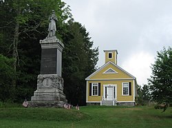
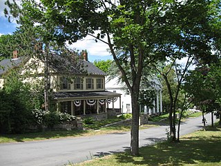
The Old Douglas Center Historic District encompasses the historic heart of Douglas, Massachusetts. The historic district radiates away from the town common, and is bounded by farmlands and more recent 20th-century development. There are 50 contributing resources in the 192-acre (78 ha) district. Most of the structures are residential houses in Federal and Greek Revival styles. There are a number of institutional buildings, including the 1834 Greek Revival First Congregational Church, the Craftsman-style Douglas Pastime Club building at 22 Church Street, and the c. 1770s Dudley Tavern. The town common and the adjacent Center Cemetery, laid out when the town was incorporated in 1746, are at the center of the district.

The Cherryfield Historic District encompasses the historic village center of Cherryfield, Maine. This area is distinctive for its collection of high-quality 19th century architecture, which is unique in rural contexts in the state. The district was listed on the National Register of Historic Places in 1990.

The Saco Historic District encompasses the historic commercial and residential centers of Saco, Maine. Covering more than 100 acres (40 ha) of central Saco, it includes houses from the 18th through 20th centuries, and the main business district along Main Street. It was added to the National Register of Historic Places in 1998.

The West Saint Clair Street Historic District is a residential historic district located along 124–328 West Saint Clair Street in the village of Almont in Almont Township in southeast Lapeer County, Michigan. It was designated as a Michigan State Historic Site and also added to the National Register of Historic Places on May 8, 1986.
The Harraseeket Historic District encompasses some of the oldest maritime village areas of the town of Freeport, Maine. It includes properties along both banks of the tidal Harraseeket River, from the Mast Landing area in the north to Wolf Neck and the villages of Porter Landing and South Freeport on the west bank of the river. The district was listed on the National Register of Historic Places in 1974.

The Freeport Main Street Historic District encompasses a 1-2 block area of Main Street in Freeport, Maine. It extends from Grove and Holbrook Streets in the south to Mill and Nathan Nye Streets in the north, just south of the L. L. Bean complex. The district, listed on the National Register of Historic Places in 1977, encompasses a well-preserved remnant of Freeport's 19th century town center.

The Main Street Historic District of Fryeburg, Maine, encompasses the growth of the town's principal village between about 1800 and 1935. It extends along Main Street, from Woodland Street in the north to Portland Street (SR 5 and Maine State Route 113) in the south, and includes forty primary buildings on 55 acres (22 ha). The district was listed on the National Register of Historic Places in 1991.

The Norway Historic District encompasses most of the historic village center of Norway, Maine, and is reflective of the town's growth over 150 years. Although significant early-to-mid 19th century buildings survive in the village, it was significantly damaged by a major fire in 1894, resulting in the construction of a number of new brick and wood frame buildings. The district, which is 44 acres (18 ha) in size, includes 64 historically significant residential, civic, social, and commercial buildings, and was listed on the National Register of Historic Places in 1988.
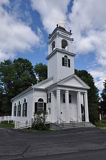
The Waterford Historic District encompasses the well-preserved historic town center, also known as Waterford Flat, of the rural inland town of Waterford, Maine. Settled in 1775, the town grew around a site where Kedar Brook empties into Keoka Lake. The oldest surviving building, the Lake House, dates to 1797, while most of the houses were built before 1850. Prominent public buildings include a series designed by John Calvin Stevens, including the Knight Library, Wilkins Community Hall, and First Congregational Church. The district was listed on the National Register of Historic Places in 1980.
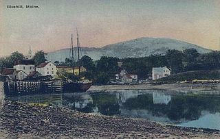
The Blue Hill Historic District encompasses the historic village center of the town of Blue Hill, Maine. The village, established in 1762, is a well-preserved collection of buildings, many of them built before 1840. Most of the older buildings are residential in character; the modest collection of commercial and civic buildings were mostly built between 1880 and 1940. The district was listed on the National Register of Historic Places in 1980.

The Calais Historic District encompasses a city block of 19th-century commercial buildings in the center of Calais, Maine. The area, developed after a fire devastated the area in 1870, contains a cohesive concentration of brick Italianate architecture. The district was listed on the National Register of Historic Places in 1978.

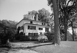
The Sargent-Roberts House is a historic house at 178 State Street in Bangor, Maine. Built in 1814 and restyled several times, the house exemplifies a local trend to update high-quality houses to the latest styles in 19th-century Bangor. The house's exterior is a Second Empire alteration of a Federal period structure, with an interior exhibiting Federal and Greek Revival features. It was listed on the National Register of Historic Places in 1996.
The Calais Residential Historic District encompasses the town's best collection of well-preserved 19th-century residences in Calais, Maine. Located on Calais Street and Main Street, the district includes twenty properties developed between the early 19th century and 1900. It was listed on the National Register of Historic Places in 1994.
The Orono Main Street Historic District encompasses a well-preserved collection of predominantly residential 19th century buildings in Orono, Maine. It extends along Main Street's west side between Maplewood Avenue and Goodridge Road, and on the east side between Spencer and Pine Streets. The area was part of Orono's early settlement, and of a period of rapid growth in the first half of the 19th century. The district was listed on the National Register of Historic Places in 1977.
The Belfast Historic District encompasses a large portion of the city center of Belfast, Maine, representing one of Maine's largest concentrations of pre-Civil War architecture, as well as a rich collection of commercial architecture of the late 19th and early 20th centuries. The district was listed on the National Register of Historic Places in 1986, with minor enlargements in 1993 and 1995.
The Lincoln House is a historic house on Maine State Route 86 in Dennysville, Maine. Built in 1787, it is the community's oldest standing structure, built during the earliest period of its settlement for Theodore Lincoln, the son of proprietor Benjamin Lincoln who oversaw the area's settlement. The house was listed on the National Register of Historic Places in 1978.
The Federal Street Historic District of Brunswick, Maine encompasses a part of the town whose development was influenced by its 18th-century success as a shipping center, and by the presence of Bowdoin College, whose historic central campus is part of the district. In addition to the campus, the district includes a series of relatively high-style Federal and later-period houses along Federal Street and Maine Street, which join the campus to downtown Brunswick. The district was listed on the National Register of Historic Places in 1976.
The Winterport Historic District encompasses a significant portion of the town center of Winterport, Maine. The town was mainly developed in the mid-19th century, when it served as the main winter port for Bangor, and features a high concentration of Greek Revival and Italianate architecture. It was listed on the National Register of Historic Places in 1975.
The Topsham Historic District encompasses the historic village center of Topsham, Maine. Extending along parts of Elm, Green, and Pleasant Streets, the area has a fine collection of 19th and early 20th-century architecture, with the majority built before 1850. It is almost entirely residential, with only a few non-residential uses, including a church. The district was listed on the National Register of Historic Places in 1978.

The Thomaston Historic District encompasses much of the historic town center of Thomaston, Maine. With a settlement history dating to the 17th century, the town is now a showcase of 19th-century architectural styles up to the 1870s. The district extends for about 2 miles (3.2 km) along United States Route 1, and was listed on the National Register of Historic Places in 1974.