
Peace Dale is a village in the town of South Kingstown, Rhode Island. Together with the village of Wakefield, it is treated by the U.S. Census as a component of the census-designated place identified as Wakefield-Peacedale, Rhode Island.

Kingston is a village and a census-designated place within the town of South Kingstown in Washington County, Rhode Island, United States, and the site of the main campus of the University of Rhode Island. The population was 6,974 at the 2010 census. Much of the village center is listed on the National Register of Historic Places as Kingston Village Historic District. It was originally known as Little Rest.
This is a list of properties and districts listed on the National Register of Historic Places in Rhode Island. As of May 29, 2015, there are more than 750 listed sites in Rhode Island. All 5 of the counties in Rhode Island have listings on the National Register.
The Rhode Island Historical Preservation and Heritage Commission, often called RIHPHC, is an agency run by the state of Rhode Island that aims to preserve the state's history and heritage. The commission works statewide to protect and upkeep historical buildings, districts, archæological sites and structures. It offers partial funding to those renovating or maintaining historical properties. It also has the role of establishing programs designed to record and celebrate the state's culture and heritage. RIHPHC has also published a series of publications on the history of each of Rhode Island's thirty nine communities and with a list of important historical places located in each.

The Roger Williams National Memorial is a landscaped urban park located on a common lot of the original settlement of Providence, Rhode Island, established by minister Roger Williams in 1636. The national memorial commemorates the life of Williams, who co-founded the Colony of Rhode Island and Providence Plantations and championed religious freedom. The park is bounded by North Main, Canal, and Smith Streets, and Park Row.

Slatersville is a village on the Branch River in the town of North Smithfield, Rhode Island, United States. It includes the Slatersville Historic District, a historic district listed on the National Register of Historic Places. The historic district has been included as part of the Blackstone River Valley National Historical Park. The North Smithfield Public Library is located in Slatersville.
Carolina is a village that straddles the border of the towns of Charlestown and Richmond on the Pawcatuck River in Washington County, Rhode Island. Rhode Island Route 112 passes through the village. Carolina is identified as a census-designated place, with a population of 970 at the 2010 census.

The Old Colony House, also known as Old State House or Newport Colony House, is located at the east end of Washington Square in the city of Newport, Rhode Island, United States. It is a brick Georgian-style building completed in 1741, and was the meeting place for the colonial legislature. From independence in 1776 to the early 20th century, the state legislature alternated its sessions between here and the Rhode Island State House in Providence.
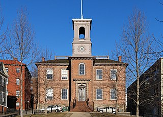
The Old State House on College Hill in Providence, Rhode Island, also known as Providence Sixth District Court House,Providence Colony House, Providence County House, and Rhode Island State House is located on 150 Benefit Street, with the front facade facing North Main Street. It is a brick Georgian-style building largely completed in 1762. It was used as the meeting place for the colonial and state legislatures for 149 years.

This is a list of the National Register of Historic Places listings in Providence, Rhode Island.
The Conanicut Battery is a colonial and 20th century military battery in Jamestown, Rhode Island, west of Beaver Tail Road. The site offers a commanding view of the West Passage of Narragansett Bay.

The Jamestown Windmill is a smock mill in Jamestown, Rhode Island within the Windmill Hill Historic District on North Road north of Weeden Lane.
The Millrace Site, RI-1039 is an archaeological site near Scituate, Rhode Island.
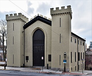
The State Arsenal, originally the Providence Marine Corps of Artillery Arsenal, and commonly called the Benefit Street Arsenal is a historic armory building located at 176 Benefit Street in the College Hill neighborhood of Providence, Rhode Island. It was built in 1829, was designed by Russell Warren in the Gothic Revival style, and was built by Tallman & Bucklin.

The Jireh Bull Blockhouse is an historic archaeological site on Middlebridge Road in South Kingstown, Rhode Island. In 1657 a blockhouse was built on the site by Jireh Bull, son of Rhode Island Governor Henry Bull. The stone garrison house was burned by the Native Americans in King Philip's War on December 15, 1675, and fifteen soldiers defending the fort were killed. The site was acquired by the Rhode Island Historical Society in 1925.

Fort Ninigret is a historic fort and trading post site at Fort Neck Road in Charlestown, Rhode Island, built and occupied by European settlers in the seventeenth century. At its 1883 dedication, Commissioner George Carmichael, Jr. referred to it as "the oldest military post on the Atlantic coast."

Queen's Fort is a historic site in Exeter, Rhode Island. Little more than a round, rocky hillock, the site has long been described as the site of a Native American fortification constructed in 1676 by Queen Quaiapen and members of the Narragansett Indian Tribe who survived the Great Swamp Massacre.

The John R. Waterman House is an historic house at 100 Old Homestead Road in Warwick, Rhode Island. The 2+1⁄2-story wood-frame house was built c. 1800 by John R. Waterman, a prominent local farmer and politician. Waterman played a significant role in what became known as Dorr's Rebellion, an ultimately successful attempt to force liberalizing changes to the state constitution. The house is an excellent local example of Federal style, and is locally distinct for its use of paired interior chimneys instead of a large central one.

The Friends Meeting House and Cemetery is a historic Quaker meeting house and cemetery at 228A W. Main Road in Little Compton, Rhode Island. The meeting house is a two-story wood-frame structure built in 1815 by the Religious Society of Friends, commonly known as Quakers, on the site of their first meeting house built in 1700 on land granted to John Irish. The new meeting house used some materials from the original one. It was then modified in 1870.

Blackstone River Valley National Historical Park is a National Park Service unit in the states of Rhode Island and Massachusetts. The park was created for the purpose of preserving, protecting, and interpreting the industrial heritage of the Blackstone River Valley and the urban, rural, and agricultural landscape of that region. The Blackstone River Valley was the site of some of the earliest successful textile mills in the United States, and these mills contributed significantly to the earliest American Industrial Revolution. The subsequent construction of the Blackstone Canal, a few years after the successful completion of the Erie Canal, helped to sustain the region's industrial strength.
