
Juan de Oñate y Salazar was a Spanish conquistador from New Spain, explorer, and colonial governor of the province of Santa Fe de Nuevo México in the viceroyalty of New Spain. He led early Spanish expeditions to the Great Plains and Lower Colorado River Valley, encountering numerous indigenous tribes in their homelands there. Oñate founded settlements in the province, now in the Southwestern United States.

The Santa Fe Trail was a 19th-century route through central North America that connected Franklin, Missouri, with Santa Fe, New Mexico. Pioneered in 1821 by William Becknell, who departed from the Boonslick region along the Missouri River, the trail served as a vital commercial highway until 1880, when the railroad arrived in Santa Fe. Santa Fe was near the end of El Camino Real de Tierra Adentro which carried trade from Mexico City. The trail was later incorporated into parts of the National Old Trails Road and U.S. Route 66.
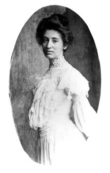
Mary Elizabeth Jane Colter was an American architect and designer. She was one of the very few female American architects in her day. She was the designer of many landmark buildings and spaces for the Fred Harvey Company and the Santa Fe Railroad, notably in Grand Canyon National Park. Her work had enormous influence as she helped to create a style, blending Spanish Colonial Revival and Mission Revival architecture with Native American motifs and Rustic elements, that became popular throughout the Southwest. Colter was a perfectionist, who spent a lifetime advocating and defending her aesthetic vision in a largely male-dominated field.

Ratón Pass is a 7,834 ft (2,388 m) elevation mountain pass on the Colorado–New Mexico border in the western United States. It is located on the eastern side of the Sangre de Cristo Mountains between Trinidad, Colorado and Raton, New Mexico, approximately 180 miles (290 km) northeast of Santa Fe. Ratón is Spanish for "mouse". The pass crosses the line of volcanic mesas that extends east from the Sangre de Cristo Mountains along the state line, and furnishes the most direct land route between the valley of the Arkansas River to the north and the upper valley of the Canadian River, leading toward Santa Fe, to the south. The pass now carries Interstate 25 and railroad tracks.

The Old Spanish Trail is a historical trade route that connected the northern New Mexico settlements of Santa Fe, New Mexico with those of Los Angeles, California and southern California. Approximately 700 mi (1,100 km) long, the trail ran through areas of high mountains, arid deserts, and deep canyons. It is considered one of the most arduous of all trade routes ever established in the United States. Explored, in part, by Spanish explorers as early as the late 16th century, the trail was extensively used by traders with pack trains from about 1830 until the mid-1850s. The area was part of Mexico from Mexican independence in 1821 to the Mexican Cession to the United States in 1848.

This is a list of properties and districts in New Mexico that are on the National Register of Historic Places. There are more than 1,100 listings. Of these, 46 are National Historic Landmarks. There are listings in each of the state's 33 counties.

The Palace of the Governors is an adobe structure built in the Territorial Style of Pueblo architecture on Palace Avenue in Santa Fe, New Mexico. Located within the Santa Fe Historic District along the Santa Fe Plaza between Lincoln and Washington avenues, it served as the seat of government for New Mexico for centuries, having been established as the capitol building of Nuevo México in 1610. It was New Mexico's seat of government until 1901.

El Santuario de Chimayó is a Roman Catholic church in Chimayo, New Mexico, United States. This shrine, a National Historic Landmark, is famous for the story of its founding and as a contemporary pilgrimage site. It receives almost 300,000 visitors per year and has been called "no doubt the most important Catholic pilgrimage center in the United States."

The historic U.S. Route 66 ran east–west across the central part of the state of New Mexico, along the path now taken by Interstate 40 (I-40). However, until 1937, it took a longer route via Los Lunas, Albuquerque, and Santa Fe, now roughly New Mexico State Road 6 (NM 6), I-25, and US 84. Large portions of the old road parallel to I-40 have been designated NM 117, NM 118, NM 122, NM 124, NM 333, three separate loops of I-40 Business, and state-maintained frontage roads.

The Camino Real de Tierra Adentro, also known as the Silver Route, was a Spanish 2,560-kilometre-long (1,590 mi) road between Mexico City and San Juan Pueblo, New Mexico, that was used from 1598 to 1882. It was the northernmost of the four major "royal roads" that linked Mexico City to its major tributaries during and after the Spanish colonial era.

The Santa Fe Plaza is a National Historic Landmark in downtown Santa Fe, New Mexico in the style of traditional Spanish-American colonial cities. The plaza, or city square is a gathering place for locals and also a tourist attraction. It is home to annual events including Fiestas de Santa Fe, the Spanish Market, the Santa Fe Bandstand, and the Santa Fe Indian Market.

El Rancho de las Golondrinas, a historic rancho and now a living history museum, is strategically located on what was once the Camino Real, the Royal Road that extended from Mexico City to Santa Fe. The ranch provided goods for trade and was a place where the caravans that plied the road would stop on their journey coming from or going to Santa Fe. It was a paraje, an official rest stop for travelers, and was even mentioned by the colonial military leader and governor, Don Juan Bautista de Anza, when he stopped here with his expeditionary force in 1780.
The Don Gaspar Historic District is a historic district in Santa Fe, New Mexico. It was listed on the National Register of Historic Places in 1983. The listing included 278 contributing buildings.

Santa Fe is the capital of the U.S. state of New Mexico, and the county seat of Santa Fe County. With over 89,000 residents, Santa Fe is the fourth-most populous city in the state, and part of the Albuquerque–Santa Fe–Los Alamos combined statistical area, which had a population of 1,162,523 in 2020. Situated at the foothills of the Sangre de Cristo Mountains, the city is at the highest altitude of any U.S. state capital, with an elevation of 7,199 feet.
Tjalke Charles Gaastra was an American architect who worked in the American southwest in the first half of the twentieth century. He won the International Exhibit of Architecture in Berlin for the Gildersleeve house in Santa Fe, New Mexico which he designed for New Mexico Supreme Court justice, David Chavez. Gaastra was a major player in the Spanish Pueblo Revival architectural style in Santa Fe, New Mexico.

Northern Rio Grande National Heritage Area is a federally designated National Heritage Area in the U.S. state of New Mexico. The national heritage area includes a section of the upper Rio Grande Valley that has been inhabited by the Puebloan peoples since the early Pre-Columbian era.

The Otowi Suspension Bridge, spanning the Rio Grande River near San Ildefonso, New Mexico, is a wooden single-lane suspension bridge for road traffic, built in 1924. It was listed on the National Register of Historic Places in 1997.
Cañoncito is an unincorporated community in Santa Fe County, New Mexico, United States. Cañoncito is located on Interstate 25, 11.5 miles (18.5 km) southeast of Santa Fe. Nuestra Señora de Luz Church and Cemetery, which is listed on the National Register of Historic Places, is located in Cañoncito.
The Camino Real in New Mexico was the northern part of a historic roadway known as the Camino Real de Tierra Adentro that from 1598 ran from Mexico City northward through central and northern Mexico and the Trans-Pecos part of what is now Texas to San Juan Pueblo in Santa Fe de Nuevo Mexico, now the state of New Mexico.

The Alvarado Hotel was a historic railroad hotel which was one of the most famous landmarks of Albuquerque, New Mexico. It was built in 1901–02 by the Atchison, Topeka and Santa Fe Railway and was operated by the Fred Harvey Company until 1970. With 120 guest rooms, it was the largest of all the Harvey hotels. Its demolition by the railroad in 1970 was described by preservationist Susan Dewitt as "the most serious loss of a landmark the city has sustained" and helped mobilize stronger support for historic preservation efforts in the city.

