
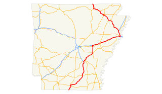
Highway 22 is an east–west state highway in the Arkansas River Valley. The highway runs 75.60 miles (121.67 km) from US 64/US 71B east to Highway 7 in Dardanelle. The highway is one of the original 1926 state highways, and is maintained by the Arkansas State Highway and Transportation Department (AHTD).
U.S. Route 63 is a north-south U.S. highway that begins in Ruston, LA. In the US state of Arkansas the highway enters the state from Louisiana concurrent with US 167 in Junction City. The highway zigzags through the state serving the major cities of Pine Bluff, West Memphis and Jonesboro. The highway exits the state at Mammoth Spring traveling into Missouri.

Highway 8 is an east–west state highway in Lower Arkansas. The route of 229.83 miles (369.88 km) runs from Oklahoma State Highway 63 (SH-63) at the Oklahoma state line east across the state to US Route 65 (US 65) south of Eudora.

The Dollarway Road is a historic road in Redfield, Arkansas that was built in 1913. It was listed on the National Register of Historic Places in 1974.

This is a list of the National Register of Historic Places listings in Hempstead County, Arkansas.

The Warren Brick Streets of Warren, Arkansas are a collection of city streets that have retained original brick pavement laid down in the late 1920s. The sections include blocks of Cedar, Myrtle, Chestnut, 1st, Walnut, Elm, and Cypress Streets, and include nearly 5,000 feet (1,500 m) of pavement. The bricks are laid out in a running bond pattern up to intersections, where a diamond pattern is used, partly to maintain the position of the bricks. The bricks measure 4 by 8.5 inches, and are probably 2 inches thick. The streets are 36 feet (11 m) wide, with 2 feet of concrete gutter and curbing. It is surmised that the bricks were laid on a concrete substrate, in part because the condition of the surviving sections is very good.

The Sumner–White Dipping Vat is a historic concrete cattle dipping vat in Ashley County, Arkansas. It is located about four miles northeast of the intersection of U.S. Highway 82 and County Road 69, half a mile in the woods northeast of the Sumner-White Hunt Club. The vat is a concrete structure about 27 feet (8.2 m) long, 4 feet (1.2 m) wide, and 7 feet (2.1 m) deep. A U-shaped concrete structure, built about the same time, stands about 2 feet (0.61 m) from the vat, near where cattle would have exited the vat. It was probably built c. 1915, when a statewide program was initiated for the eradication of Texas tick fever. The facilities were likely used until the program came to an end in 1943.
The Gregory Dipping Vat is a historic cattle dipping facility at 122 Rogers Street on the outskirts of Lake Village, Arkansas. The vat is a concrete structure 27 feet (8.2 m) long, 4 feet (1.2 m) wide, and 7 feet (2.1 m) deep. It is located on a grassy lane off Rogers Road, in a wooded area not far from Bayou Macon, whose waters were used to fill it. The vat was built c. 1930 as part of a statewide program to eradicate Texas tick fever, which was at the time a serious problem affecting the area's cattle farmers. After the program was ended in 1943, the vat became a play area for local youth. It remains in good condition as a reminder of the economically important tick eradication program.

The Dooley's Ferry Fortifications Historic District encompasses a series of military earthworks erected in southwestern Arkansas, along the Red River in Hempstead County. They were constructed in late 1864 by Confederate troops under orders from Major-General John B. Magruder as a defense against the potential movements of Union Army forces toward Shreveport, Louisiana. They command a formerly major road intersection just east of Dooley's Ferry, one of the most important regional crossings of the Red River. After the war a cemetery for African-Americans was established adjacent to one of the gun emplacements.

Old US 71-Little River Approach is a largely abandoned section of an old alignment of U.S. Route 71 (US 71) in southern Sevier County, Arkansas. Now designated Ashley Camp Road, it is a 2.75-mile-long (4.43 km) section of road, extending south from Arkansas Highway 234 to the Little River. It parallels the existing alignment of US 71, which travels to the west of this road section. The road is 18 feet (5.5 m) wide, with no shoulder, and was built in 1934 of Bates-style concrete, notable for its embedded reinforcing rods. The road was built on fill in order to raise it above the floodplain of the Little River, and includes five period bridges built as reliefs in the event of river flooding. It is the longest and most-intact section of the original US 71 alignment in the county.

The Old US 71-Jenny Lind Segment is a stretch of historic road pavement southeast of Jenny Lind, Arkansas. It consists of a bypassed section of U.S. Route 71 (US 71) that is now designated Doraul Acres Lane. It extends for about 0.75 miles (1.21 km), traveling roughly parallel to, and south of, the current alignment of US 71 between Hidden Valley Way and Shadow Lake Drive. It is concrete pavement 18 feet (5.5 m) wide with no shoulder, and there is a single concrete slab bridge, which spans Bear Creek. This roadway section was built 1927-29, when US 71 was first built. It was bypassed in 1959.
The Square Rock Dipping Vat is a historic former cattle dipping facility in Ouachita National Forest, northeast of Waldron, Arkansas. It is located south of Square Rock Creek, off a forest road that runs south from County Road 94. It is a partially buried U-shaped concrete structure, with a concrete pad at one end, through which cattle were directed to dip them with chemical treatment for Texas tick fever. A barbed-wire holding pen of uncertain age stands nearby. It is believed to have been built about 1920, and was probably used until 1943, when the disease was determined to have been eradicated.
The Cogburn Dipping Vat is a historic former cattle dipping facility in Ouachita National Forest, west of Black Spring, Arkansas. It is located about 19 metres (62 ft) west of Forest Road 73 and south of a perennial stream. It is a U-shaped concrete structure, with a distinctive curved shape that matches the contours of the terrain, with a concrete pad at one end. The total length of the structure is about 13 metres (43 ft). It was built between 1930 and 1940 as part of a state program to eradicate Texas tick fever from the state's cattle. The vat's name derives from the Cogburn, who homesteaded a farm in the area, and probably built the vat to serve their needs and those of other nearby farmers.
The Guinn Dipping Vat is a historic former cattle dipping facility in Ouachita National Forest, northwest of Mount Ida, Arkansas in the ghost town of Mauldin. It is located south of Forest Road 37 west of United States Route 270. It is a U-shaped concrete structure with a concrete and stone drip pad at one end, and is covered with boards. The vat was built c. 1940 by Mack Guinn to serve the local farm population in its efforts to eradicate Texas tick fever.
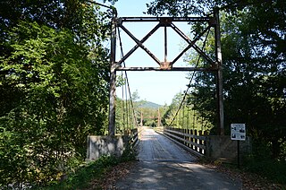
The Sylamore Creek Bridge is a historic bridge in east central Stone County, Arkansas, just south of the Ozark-St. Francis National Forest. It carries County Road 283 across Sylamore Creek, a short way west of Arkansas Highway 9 and north of the Holiday Mountain Resort in Allison. It is a wire-cable suspension bridge, with steel towers mounted on concrete piers supporting four main cables that are anchored into concrete abutments. The bridge is 202 feet (62 m) long, with a deck width of 19 feet 6 inches (5.94 m) and a clearance height of 11 feet (3.4 m). Built in 1945, it is one of three known wire-cable bridges in the state.

The Johnson County Line-Ozark-Crawford County Line Road, Altus Segment is a historic roadbed in Altus, Arkansas. It consists of a 425-foot (130 m) section of stone-paved roadbed, located on the north side of Arkansas Highway 64 between Robin Way and County Road 515. The roadbed is about 10 feet (3.0 m) wide, with gravel shoulders, and has a small concrete bridge spanning a ditch. Built sometime between c. 1918 and 1931, it is the only known example of stone pavement in rural Arkansas.

The Jim Wright Farmstead Historic District encompasses a well-preserved early 20th-century farmstead in rural White County, Arkansas. The property is located on the south side of Arkansas Highway 258, east of its junction with Arkansas Highway 323, northwest of Bald Knob. It includes a Craftsman style single-story wood frame farmhouse, with a wraparound porch supported by simple Doric columns, a simple wood-frame garage, and a single-story wood frame house for tenant workers. It also includes remnants of the farmstead's first house and barn, silo, and a cattle dipping vat. This land was homesteaded in 1860 by the parents of Jim Wright, who is credited with construction of most of the farmstead's surviving features, which were built between 1924 and 1940.

The Van Buren County Road 2E Bridge is a historic bridge in rural southwestern Van Buren County, Arkansas. It is a three-span open concrete masonry structure, with each span measuring 12 feet (3.7 m) in length, carrying County Road 2E across an unnamed tributary of Driver's Creek. The bridge rests on piers and abutments of stone and concrete, and has a roadway deck 19.9 feet (6.1 m) wide. It was built in 1940 with funding from the Works Progress Administration, and is a well-preserved example of a period concrete bridge.

The Pottsville Dipping Vat is a historic cattle processing structure in Rankin Park, on East Ash Street in Pottsville, Arkansas. It consists of a U-shaped concrete structure, with an extended base at one end. The structure has a total length of 42 feet (13 m), and the vat is 2 feet (0.61 m) wide and 7 feet (2.1 m) deep. It was probably built about 1915, not long after the state began a program to eradicate Texas cattle fever from its livestock.

The Brinkley Concrete Streets are several road sections in Brinkley, Arkansas. They include one block of Ash Street, and several on New York Street. These roads are two lanes wide, and were built in 1928-29 out of concrete sections 14 feet (4.3 m) wide and about 24 feet (7.3 m). They were among the first 4 miles (6.4 km) of city streets to be paved, and followed the practice of the nearby Bankhead Highway sections, which were also built in concrete.


