Highway 22 is an east–west state highway in the Arkansas River Valley. The highway runs 75.60 miles (121.67 km) from US 64/US 71B east to Highway 7 in Dardanelle. The highway is one of the original 1926 state highways, and is maintained by the Arkansas State Highway and Transportation Department (AHTD).

Highway 21 is a north–south state highway in north central Arkansas. The route of 99.14 miles (159.55 km) runs from US Route 64 (US 64) in Clarksville north across US 62 to Missouri Route 13 at the Missouri state line The route is entirely a two-lane route with the exception of a brief concurrency with US 62 in Berryville.

State Road 2 is a former east–west state highway in the Arkansas Timberlands and Lower Arkansas Delta. The route was approximately 195 miles (314 km), and ran from US Route 67 (US 67) in Texarkana east to cross the Mississippi River near Lake Village, continuing as Mississippi Highway 10. On July 1, 1931, the route was entirely replaced by US Highway 82 (US 82) by the American Association of State Highway Officials (AASHTO). The route was maintained by the Arkansas Highway Department (AHD), now known as the Arkansas Department of Transportation (ArDOT).

Highway 103 is a designation for two north–south state highways in north central Arkansas. One segment of 23.86 miles (38.40 km) runs north from Marina Road and Lakeview Drive in Clarksville to Highway 215 in the Ozark National Forest. A second route of 39.81 miles (64.07 km) begins at Highway 43 in the Buffalo National River area administered by the National Park Service and runs north across US Highway 412 (US 412) to Highway 21 in Oak Grove.
Highway 164 is a designation for four segments of state highway in the Arkansas River Valley. One route of 13.3 miles (21.4 km) begins at US Highway 64 (US 64) in Coal Hill and runs east to Highway 103. A second route of 16.6 miles (26.7 km) begins at Highway 21 in Clarksville and runs east to Highway 7. A third route of 1.8 miles (2.9 km) begins at Highway 27 and runs north to the Ozark National Forest. A fourth segment begins at Highway 7 in Dover and runs 9.8 miles (15.8 km) east to Highway 105. In Clarksville, a spur route of 0.2 miles (0.32 km) known as Highway 164 Spur or Scoggins Street serves the Clarksville Municipal Airport. All routes are maintained by the Arkansas State Highway and Transportation Department (AHTD).

Highway 190 is a designation for four state highways in Arkansas. Three are low-traffic rural highways in Grant County, with one designation along city streets in Pine Bluff. The rural segments were created in 1965 and 1966, with the Pine Bluff section created in 2000. All segments are maintained by the Arkansas Department of Transportation (ARDOT).

Old US 71 – Wilton Segment is a former alignment of U.S. Route 71 (US 71) near Wilton in Little River County, Arkansas. The roadway of about 2 miles (3.2 km) is a 1934 construction and was the main travel route in the county upon construction until US 59/US 71 bypassed this alignment in 1965.

Old US 79, Kingsland Segment is a rare drivable section of concrete highway built in 1938 near Kingsland, Arkansas. It is also one of a few surviving sections of the original alignment of U.S. Route 79 (U.S. 79) in Arkansas. The road that became US 79 had been laid out by 1916, and was paved with asphalt in 1930. In the mid 1930s, the state embarked on a program of removing dangerous grade crossings where major routes crossed railroad tracks. In 1938, it awarded a contract to S. M. Dixon to build an overpass at the crossing of US 79 and the St. Louis Southwestern Railway line. Dixon built a 655-metre-long (2,149 ft) section of concrete roadway, 22 feet (6.7 m) wide, with a concrete deck girder bridge to cross the tracks. This section of US 79 remained in service until 1954, when the current alignment to its northeast was built. It has since been designated County Road 22. The concrete is in good condition; it has been covered in chip seal for about half its length.

The Camden to Washington Road-Rosston Segment is a historic early 19th-century road section in rural Nevada County, Arkansas. It is located east of Rosston in Poison Spring State Forest, and is a former portion of County Road 10 extending east from that road's junction with County Road 47. The road was first cut c. 1825, and was never paved or given modern finishing, despite its continued use well into the 20th century. A crossing at Cypress Creek has been compromised by the activities of beavers, and the road is no longer completely passable, possibly excepting high-clearance off-road vehicles. The road section is the one of the only sections of the historic post road which connected Washington and Camden to retain its 19th-century character.
The Memphis to Little Rock Road-Village Creek Segment is a historic military road in Cross County, Arkansas. Located entirely within Village Creek State Park, this 1.5-mile (2.4 km) segment of roadway is one of the best-preserved portions of the military road built between Memphis, Tennessee and Little Rock, Arkansas in 1828. This road is notable for the large numbers of westward-traveling pioneers who used it en route to settling the American Plains, and for its use in the forced migration of several Native American tribes in the 1830s. The roadway portion, in parts set in dramatically deep cuts in the hills, extends from Village Creek in the east to the western boundary of the park, and is accessible today as a hiking trail.

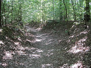
The Springfield to Fayetteville Road-Cross Hollow Segment is a 2-mile (3.2 km) section of a historic 19th-century road in Benton County, Arkansas. The road is now designated Old Wire Road, and the historic segment runs northward from its junction with County Road 620, northeast of Lowell. This road bed is a part of one of the first roads built in the area, running from Fayetteville, Arkansas to Springfield, Missouri. Built in 1835, the road bed has its original width and original embankments. The road is notable as part of the northern route of the Trail of Tears, when Native Americans living east of the Mississippi River were forcibly relocated to what is now Oklahoma, and for its use in military operations during the American Civil War. It is the longest known intact segment of the Trail of Tears in Arkansas.

The Springfield to Fayetteville Road-Elkhorn Tavern Segment is a section of historic 19th-century roadway in Pea Ridge National Military Park in northwestern Arkansas. It is a dirt road, about 1 mile (1.6 km) long and 18 to 20 feet wide, that was built in 1835. The first major road through northwestern Arkansas, it connected Fayetteville, Arkansas with Springfield, Missouri. The road was part of the major northern route of the Trail of Tears, the forcible remove in the late 1830s of Native Americans from east of the Mississippi River to what is now Oklahoma. The road was also actively used by both Union and Confederate forces during the American Civil War, and was the major route of advance by Confederate forces leading to the Battle of Pea Ridge, whose battlefield is preserved by the park.

The Butterfield Overland Mail Route Lee Creek Road Segment is a historic stretch of road in Crawford County, Arkansas. It is a 3.1-mile (5.0 km) segment of Lee Creek Road, which diverges from Arkansas Highway 220 north of Cedarville. This road section appears to closely follow the original alignment of the main road in the region in 1839, which connected Fayetteville and Van Buren. This road was used by the Butterfield Overland Mail service between 1858 and 1861. It is a gravel roadway about 12 feet (3.7 m) wide, with several deeply-cut sections.
The Memphis to Little Rock Road-Henard Cemetery Road Segment is a section of historic roadway in Monroe County, Arkansas. It consists of 650 metres (2,130 ft) of the middle of Henard Cemetery Road, located northeast of the hamlet of Zent in the far northeastern part of the county. The roadway section is one of three known places where the original 19th-century appearance of the first road to connect Memphis, Tennessee to Little Rock, Arkansas is preserved. The far ends of the road have been impacted by development and agriculture, and do not convey the sense of the road's early appearance. The road is also historically important as it was used as part of the Trail of Tears, the forced removal of Native Americans east of the Mississippi River to what is now Oklahoma.
The Memphis to Little Rock Road-Bayou Two Prairie Segment is a historic military road section in Lonoke County, Arkansas. Located north of Lonoke near the hamlet of Brownsville, the road section was part of the 1828 Memphis to Little Rock Military Road. It was used in the 1830s during the Trail of Tears removal of eastern Native American tribes, and was used by military forces on both sides of the American Civil War leading up to the Battle of Brownsville.
The Memphis to Little Rock Road-Brownsville Segment is a historic military road section in Lonoke County, Arkansas. Located north of Lonoke near the hamlet of Brownsville, the road section was part of the 1828 Memphis to Little Rock Military Road. It was used in the 1830s during the Trail of Tears removal of eastern Native American tribes, and was used by military forces on both sides of the American Civil War leading up to the Battle of Brownsville.
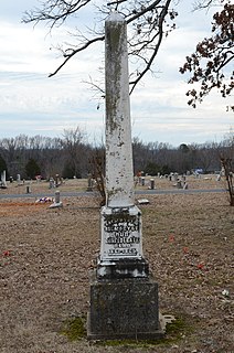
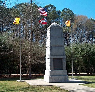
The Clarksville Confederate Monument is located in the south-central section of Oakland Cemetery in Clarksville, Arkansas. It is a white marble obelisk, 10 feet (3.0 m) in height, which is 21.5 inches (55 cm) square at its base. It is mounted on a limestone pedestal 2 feet (0.61 m) square and 22 inches (56 cm) in height. The lower portion of the obelisk is carved with an inscription commemorating the Confederate war dead, and its spire is adorned with a floral pattern. It was placed about 1902 by the local chapter of the United Daughters of the Confederacy.

The Clarksville National Guard Armory is a historic former National Guard Armory at 309 College Street in Clarksville, Arkansas. It is a two-story building, finished in brick with restrained Art Deco styling. Its main facade is 10 bays wide, with a projecting section at the center housing two bays on the upper floor, and a double door entrance on the first. The entrance is set in a stepped recess, and it and the windows above are flanked by brick pilasters at the corner of the projection. The building was built in 1930, and served the Arkansas National Guard as a training and storage facility until 1980, after which ownership was turned over to the city.

The Johnson County Courthouse is located at Main and Fulton Streets in downtown Clarksville, the county seat of Johnson County, Arkansas. It is a three-story masonry structure, built out of brick and rusticated concrete blocks. It has a Classical Revival facade, with a seven-bay projecting section. Windows and entrances on the ground floor are set in round-arch openings, while the upper level windows are rectangular sash, set in bays articulated by pilasters. It was built in 1934 with funding support from the Federal Emergency Administration, and is the county's third courthouse.
Highway 51 is a designation for two north–south state highways in Southwest Arkansas. One route of 53.37 miles (85.89 km) begins Highway 53 near Whelen Springs and runs north to US Highway 67 in Donaldson. A second route of 7.92 miles (12.75 km) runs parallel to US 270 northwest of Malvern. Both routes are maintained by the Arkansas Department of Transportation (ArDOT).