
Gosford is a waterfront city at the northern end of Brisbane Water on the Central Coast in the state of New South Wales, Australia. The Gosford Waterfront is known for its boating and scenic views on the shores of Brisbane Water. Gosford is the main commercial hub and gateway of the Central Coast. It is situated approximately 77 km (48 mi) north of Sydney and 86 km (53 mi) south of Newcastle. Gosford is located in the local government area of the Central Coast Council.

Brisbane is the capital and largest city of the state of Queensland and the third-most populous city in Australia and Oceania, with a population over 2.7 million. Brisbane lies at the centre of South East Queensland, an urban agglomeration with a population of approximately 4 million which includes several other regional centres and cities. The central business district is situated within a peninsula of the Brisbane River about 15 km (9 mi) from its mouth at Moreton Bay. Brisbane is located in the hilly floodplain of the Brisbane River Valley between Moreton Island and the Taylor and D'Aguilar mountain ranges. It sprawls across several local government areas, most centrally the City of Brisbane. The demonym of Brisbane is Brisbanite.
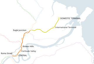
Airtrain is the privately owned commuter railway line that extends 13.0 km (8.1 mi) northeast from Brisbane, the state capital of Queensland, to Brisbane Airport (BNE) at both its separate International and Domestic terminals. It was opened in 2001.

The Doomben railway line is a railway line in the City of Brisbane, Queensland, Australia. It is the part of the Pinkenba railway line that still operates a regular passenger service. Doomben, or dumben, is the Indigenous Yuggera name for a tree fern which was prolific in the area. The railway line branches from the North Coast line at Eagle Junction, extending 8 kilometres (5.0 mi) to the industrial suburb of Pinkenba, situated on the northern bank at the mouth of the Brisbane River. It is part of the Queensland Rail Citytrain network.

Wooloowin is a suburb in the City of Brisbane, Queensland, Australia. In the 2021 census, Wooloowin had a population of 4,029 people.

Central Plaza One a skyscraper in the city of Brisbane, Queensland, Australia, was designed by renowned Japanese architect Kurokawa Kisho. The height of the tower is 174 m (571 ft) and it contains 44 floors.

Originally named the AMP Centre, Gold Tower is a gold-coloured skyscraper located in the heart of the Brisbane central business district in Queensland, Australia. It can be seen from most parts of the city.

Pinkenba is a town and eastern coastal suburb within the City of Brisbane, Queensland, Australia. In the 2021 census, Pinkenba had a population of 350 people.

Clayfield is a suburb in the City of Brisbane, Queensland, Australia. In the 2021 census, Clayfield had a population of 10,897 people.

Riverside Centre is a heritage-listed office building at 123 Eagle Street, Brisbane CBD, City of Brisbane, Queensland, Australia. It was designed by Harry Seidler. and was built in 1986. Completed in 1986, it contains 40 storeys and rises 146 metres (479 ft) above ground. The building is owned by General Property Trust. It was added to the Queensland Heritage Register on 1 December 2023.

Eagle Farm is an eastern industrial suburb of the City of Brisbane, Queensland, Australia. In the 2021 census, Eagle Farm had a population of 11 people.

Uptown is a six-floor shopping complex located on the Queen Street Mall in the central business district of Brisbane, Queensland, Australia. The centre was named The Myer Centre from its opening in 1988 to 2023 as it used to house Queensland's largest Myer department store.

Brisbane City is the central suburb and central business district of Brisbane, the state capital of Queensland, Australia. It is also colloquially referred to as the "Brisbane CBD", "the city", or simply "town". The CBD is located on a point on the northern bank of the Brisbane River, historically known as Meanjin, Mianjin or Meeanjin in the local Yuggera dialect. The triangular-shaped peninsula is bounded by the median of the Brisbane River to the east, south and west. The point, known at its tip as Gardens Point, slopes upward to the north-west where the city is bounded by parkland and the inner city suburb of Spring Hill to the north. The CBD is bounded to the north-east by the suburb of Fortitude Valley. To the west the CBD is bounded by Milton, Petrie Terrace, and Kelvin Grove.

Hendra is a suburb of the City of Brisbane, Queensland, Australia. In the 2021 census, Hendra had a population of 4,914 people.

Elizabeth Street is a major street in the centre of the city in Brisbane, Queensland, Australia. The street was one of the earliest in Brisbane being established at the beginning of settlement in Brisbane as Moreton Bay penal settlement. Today, most of the street is fronted by low-level retail outlets, with an increase in mixed use skyscrapers being recently constructed.

Charlotte Street is a road in the central business district of Brisbane, Queensland, Australia. The street is one of a number that were named after female queens and princesses of the royal family shortly after the penal colony was settled. Mary Street runs parallel to the south and Elizabeth Street is the next street to the north.

One One One Eagle Street is a 194.7-metre (639 ft) office building at 111 Eagle Street, Brisbane, Queensland, Australia, located in the city centre. With 6 star Green Star office design rating, the building is part of the CBD's 'Golden Triangle' district. Its location is the site of the old Indigo House building, which was demolished over a period of six months starting in 2008. 95% of all waste from the old building is to be recycled or reused.

Creek Street is a major street in the central business district of Brisbane, Queensland, Australia. The street follows a one-way south–north direction, starting at the beginning of Charlotte Street and cutting through Elizabeth Street, Queen Street, Adelaide Street, and Ann Street before coming to an end at Turbot Street in the northern end of the CBD. Creek Street was named for the filled-in creek over which it was constructed, and is an exception to the convention of parallel streets in the CBD being named after male royals.
Dexus is an Australian real estate investment trust. Founded in 1984, it is listed on the Australian Securities Exchange.
