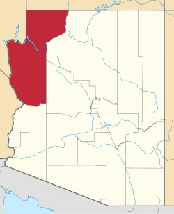
Eastbridge was a railroad station on the east bank of the Colorado River in Mohave County, Arizona, United States. It was located at the site of the first bridge the Atlantic and Pacific Railroad built across that river, three miles southeast of Needles, in San Bernardino County, California.
The wooden bridge across the Colorado River constructed between Eastbridge station and the California bank in 1883 was built across the wet alluvial soils of the flood plain of the Mohave Valley. The site had no solid base on either bank and was over 1600 feet wide. The construction was conducted during the flood season of the Colorado that began in May. For three months, the building crews struggled to drive wooden pilings into the river bed only to see them washed out by the river. Pilings were only driven into the mid river section with the help of a pile driver mounted on Barge No. 3, towed and held in position by the Mohave II. This first bridge, when completed in August was still vulnerable to flooding and was washed out or undermined by the spring flooding of the river and had to be replaced in 1884, 1886 and 1888. Finally the railroad changed its route southward along the California bank, to Beal, then to a place opposite Mellen, where from 1889 to May 1890 they built the Red Rock Bridge, a cantilever bridge, on rock foundations, unlike the previous site. After completion of the bridge, the section of track between the point where the line changed direction to the new bridge, to the station of Powell and to the bridge and station at Eastbridge, was abandoned in 1890. [1] :82
A transcontinental railroad or transcontinental railway is contiguous railroad trackage that crosses a continental land mass and has terminals at different oceans or continental borders. Such networks can be via the tracks of either a single railroad or over those owned or controlled by multiple railway companies along a continuous route. Although Europe is crisscrossed by railways, the railroads within Europe are usually not considered transcontinental, with the possible exception of the historic Orient Express. Transcontinental railroads helped open up unpopulated interior regions of continents to exploration and settlement that would not otherwise have been feasible. In many cases they also formed the backbones of cross-country passenger and freight transportation networks. Many of them continue to have an important role in freight transportation and some like the Transsiberian Railroad even have passenger trains going from one end to the other.
Bullhead City is a city located on the Colorado River in Mohave County, Arizona, United States, roughly 90 mi (140 km) south of Las Vegas, Nevada, and directly across the Colorado River from Laughlin, Nevada, whose casinos and ancillary services supply much of the employment for Bullhead City. Bullhead City is located on the southern border of Lake Mohave. According to the 2010 census, the population of the city is 39,540. The nearby communities of Laughlin, Needles, California, Fort Mohave and Mohave Valley bring the Bullhead area's total population to about 100,000, making it the largest micropolitan area in Mohave County.
Needles is a city in eastern San Bernardino County, California, United States. It lies on the western banks of the Colorado River in the Mohave Valley subregion of the Mojave Desert, near the borders of Arizona and Nevada and roughly 110 miles (180 km) from the Las Vegas Strip.
The Mohave Valley is a valley located mostly on the east shore of the south-flowing Colorado River in northwest Arizona. The valley extends into California's San Bernardino County; the northern side of the valley extends into extreme southeast Clark County, Nevada. The main part of the valley lies in southwest Mohave County, Arizona and is at the intersection of the southeast Mojave and northwest Sonoran deserts.
Fairbank is a ghost town in Cochise County, Arizona, next to the San Pedro River. First settled in 1881, Fairbank was the closest rail stop to nearby Tombstone, which made it an important location in the development of southeastern Arizona. The town was named for Chicago investor Nathaniel Kellogg Fairbank who partially financed the railroad, and was the founder of the Grand Central Mining Company, which had an interest in the silver mines in Tombstone. Today Fairbank is located within the San Pedro Riparian National Conservation Area.
Topock ( ) is a small unincorporated community in Mohave County, Arizona, United States. Topock has a ZIP Code of 86436; in 2000, the population of the 86436 ZCTA was 1,790.
The Sacramento Mountains are a mountain range in the Eastern Mojave Desert and within Mojave Trails National Monument, in San Bernardino County, California.
The Atlantic and Pacific Railroad was a U.S. railroad that owned or operated two disjointed segments, one connecting St. Louis, Missouri with Tulsa, Oklahoma, and the other connecting Albuquerque, New Mexico with Southern California. It was incorporated by the U.S. Congress in 1866 as a transcontinental railroad connecting Springfield, Missouri and Van Buren, Arkansas with California. The central portion was never constructed, and the two halves later became parts of the St. Louis-San Francisco Railway and Atchison, Topeka and Santa Fe Railway systems, now both merged into the BNSF Railway.
The Mohave and Milltown Railway was a 3 ft narrow gauge private railroad built in 1903 to serve the Leland Gold Mine near Oatman, Arizona, USA. The railway was incorporated in 1903 and construction of the 17-mile (27 km) line was completed that same year. The railway started on the Arizona side of the Colorado River, across the stateline from Needles, California. From the Colorado River the railway went northeast through Milltown and terminated at the Leland Mine, Vivian Mine and the Midnight Mine.
The California Southern Railroad was a subsidiary railroad of the Atchison, Topeka and Santa Fe Railway in Southern California. It was organized July 10, 1880, and chartered on October 23, 1880, to build a rail connection between what has become the city of Barstow and San Diego, California.
The Mojave Road, also known as Old Government Road, is a historic route and present day dirt road across what is now the Mojave National Preserve in the Mojave Desert in the United States. This rough road stretched 147 miles (237 km) from Beale's Crossing, to Fork of the Road location along the north bank of the Mojave River where the old Mojave Road split off from the route of the Old Spanish Trail/Mormon Road.
The 112,400-acre (45,500 ha) Warm Springs Wilderness makes up the entirety of the Black Mesa and parts of the surrounding foothills, washes, alluvial fans, and valleys. The Black Mesa is the southernmost section of the Black Mountains of western Mohave County, in northwest Arizona. The region is in the east and southeast of the Mojave Desert of Arizona, southern Nevada, and California.
The Sacramento Wash is a major drainage of northwest Arizona in Mohave County. The wash is east of the Black Canyon of the Colorado and drains into the south-flowing Colorado River 45 mi south of Lake Mohave, and 90 mi south of Hoover Dam at Lake Mead. The wash outfall is in the center-south of the Havasu-Mohave Lakes Watershed. An equivalent wash drains to the west of the Colorado River and the Black Canyon, draining southeast Nevada and a small part of California, the Piute Wash of the Piute Valley. The Piute Wash outfall is upstream of the Sacramento's outfall by about 15 miles.
The Mohave Mountains are a small 18-mi (29 km) long mountain range of northwest Arizona. The range is a northwest trending range in southwest Mohave County that parallels a southeast-flowing stretch of the Colorado River, the Arizona-California border. The range also forms the southwest border of a flatland region to its east and north, namely, Dutch Flat which lies east, at the south end of Sacramento Valley. Lake Havasu City, AZ on the Colorado, lays opposite the southwest flank of the range, where the London Bridge was reconstructed at Lake Havasu.
Steamboats on the Colorado River operated from the river mouth at the Colorado River Delta on the Gulf of California in Mexico, up to the Virgin River on the Lower Colorado River Valley in the Southwestern United States from 1852 until 1909, when the construction of the Laguna Dam was completed. The shallow draft paddle steamers were found to be the most economical way to ship goods between the Pacific Ocean ports and settlements and mines along the lower river, putting in at landings in Sonora state, Baja California Territory, California state, Arizona Territory, New Mexico Territory, and Nevada state. They remained the primary means of transportation of freight until the advent of the more economical railroads began cutting away at their business from 1878 when the first line entered Arizona Territory.
Powell was a railroad station and settlement in Mohave County, Arizona, United States from 1883 to 1890.
Beal, was a railroad station on the Atlantic and Pacific Railroad line between Needles, California and Topock, Arizona from 1889. It was located 5 miles north on the railroad line to Needles from Mellen.
Polhamus Landing, or Welton & Grounds Landing, was a steamboat landing in Mohave County, Arizona, United States during 1881 and 1882.
The Red Rock Bridge was a bridge across the Colorado River at Topock, Arizona that carried the Atlantic & Pacific Railroad. It was built in 1890, replacing a wooden bridge dating to 1883 that was repeatedly washed out during spring flooding. It was used by the railroad until 1945 when a new bridge was built. The Red Rock Bridge was then converted to carry the automobile traffic of U.S. Route 66, and did so from 1947 until 1966 when Route 66 traffic was directed onto the Interstate 40 bridge. At that time the Red Rock Bridge was abandoned, and it was eventually dismantled in 1976.