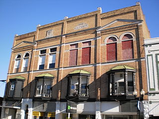
El Dorado, founded by Matthew Rainey, is a city in, and the county seat of, Union County, on the southern border of Arkansas, United States. According to the 2010 census, the population of the city is 18,884.

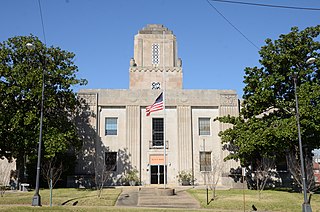
The Masonic Temple of El Dorado, Arkansas is located at 106-108 North Washington Street, on the west side of the courthouse square. The four-story masonry building was built in 1923–24 to a design by Little Rock architect Charles S. Watts. It is one of a small number of buildings in Arkansas with Art Deco styling influenced by the Egyptian Revival. This particular styling was likely influence by the 1922 discovery of the Tomb of Tutankhamun.

The Hartford City Courthouse Square Historic District is located in Hartford City, Indiana. Hartford City has a population of about 7,000 and is the county seat of Blackford County and the site of the county courthouse. The National Park Service of the United States Department of the Interior added the Hartford City Courthouse Square Historic District to the National Register of Historic Places on June 21, 2006 — meaning the buildings and objects that contribute to the continuity of the district are worthy of preservation because of their historical and architectural significance. The District has over 60 resources, including over 40 contributing buildings, over 10 non-contributing buildings, 1 contributing object, 8 non-contributing objects, and two other buildings that are listed separately in the National Register.

The Fayetteville Historic Square, in Fayetteville, Arkansas, includes the original Fayetteville post office, the Old Bank of Fayetteville Building, the Lewis Brothers Building, the Mrs. Young Building, and the Guisinger Building. These buildings are listed in the National Register of Historic Places. There are several more recent buildings located on the Square.
Mann & Stern was an architectural partnership in Arkansas of Eugene John Stern (1884-1961) and George Richard Mann (1856-1939).
The Monticello Commercial Historic District encompasses a portion of the historic business district of Monticello, the seat of Drew County, Arkansas. The district was listed on the National Register of Historic Places in 2011.

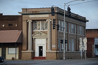
The Bank of Commerce building is a historic commercial building at 200 North Washington Street in El Dorado, Arkansas. The Classical Revival two story brick building was constructed in 1919–20, and is one of the few buildings in El Dorado's downtown that retains its historical facade from that period. The building was renovated in the 1940s and 1950s, actions that gutted its interior, but only covered over the main facade with a new layer of brick, and left the secondary southern facade intact. In the early 1980s the building's exterior was restored to its 1920s appearance.

The El Dorado Confederate Monument is located on the grounds of the Union County Courthouse in El Dorado, Arkansas, near the corner of North Main and South Washington Streets. It consists of a statue of a Confederate Army soldier in mid-stride, mounted on top of a temple-like structure supported by four cannon-shaped Ionic columns. The columns support a lintel structure bearing inscriptions on three sides, above which is a tiered roof with cannonballs at the corners. The temple structure is 15 feet (4.6 m) high, and 10 feet (3.0 m) square; the statue measures 76 inches (1.9 m) by 28 inches (0.71 m) by 28 inches (0.71 m). Both the statue and the temple are constructed of gray/blue striated marble.

The Exchange Bank building, formerly the Lion Oil Headquarters, is a historic commercial building at Washington and Oak Streets in El Dorado, Arkansas. Built in 1926–27, the nine story building was the first skyscraper in Union County, and it was the tallest building in El Dorado at the time of its listing on the National Register of Historic Places in 1986. It was designed by the Little Rock firm of Mann & Stern, and is an eclectic mix of Venetian-inspired Revival styles. It was built during El Dorado's oil boom, and housed the headquarters of Lion Oil. It was included in the El Dorado Commercial Historic District in 2003.

The Griffin Auto Company Building is a historic automobile sales and service facility at 117 East Locust Street in El Dorado, Arkansas. It is a single story structure built out of reinforced concrete, with a full basement. The main floor housed the sales and showroom area, and the service area was in the basement. The building also includes a filling station area, which is the most decorative portion of the otherwise utilitarian structure. This area has pilastered columns that frame the automobile entry area, and the walls above the shelter entrance is decorated with bands of terra cotta and brick ornamentation. The Griffin Auto Company was established by three brothers from North Carolina, beginning as a livery stable business in 1899 before branching out into the new world of the automobile in 1915. They moved out of the building in 1960, since when it has been used by a variety of other sales-oriented businesses. In 2017, the Griffin Restaurant opened as part of the Murphy Arts District. Four years later, it became the MuleKick.

The Municipal Building, or City Hall, of El Dorado, Arkansas is located at 204 North West Street.

The Murphy–Hill Historic District encompasses the oldest residential portion of the city of El Dorado, Arkansas. It is located just north of the central business district, bounded on the north by East 5th Street, on the west by North Jefferson and North Jackson Avenues, on the east by North Madison Avenue, and on the south by East Peach and East Oak Streets. Six of the 76 houses in the 40-acre (16 ha) district were built before 1900, including the John Newton House, one of the first buildings to be built in El Dorado. Of particular note from this early period is a highly elaborate Queen Anne Victorian at 326 Church Street.

The Prescott Commercial Historic District encompasses the historic commercial core of Prescott, Arkansas, the county seat of Nevada County. Prescott was laid out in 1873, after the railroad was built through the area that is now Nevada County, and the railroad has played a significant role in the city's development. The railroad today bisects the commercial core of the city, which extends for several city blocks away from the railroad. The historic district includes all of the major civic buildings of the city, including the courthouse, post office, and the old Prescott City Jail.

The DeQueen Commercial Historic District encompasses part of the commercial heart of downtown De Queen, Arkansas. The district is centered on the block containing the Sevier County Courthouse, a three-story brick Colonial Revival structure built in 1930. It includes buildings facing the courthouse square on West DeQueen Avenue, West Stilwell Avenue, and North Third Street, and extends an additional block eastward to North Second Street. This commercial heart of the city was developed mainly between 1900 and 1920, and includes 21 historically significant buildings. Notable among them is the former Hayes Hardware Building at 314 West DeQueen, built c. 1900, and the Bank of DeQueen at 221 West DeQueen, also built c. 1900.

The DeWitt Commercial Historic District encompasses part of the historic downtown of De Witt, Arkansas, the seat of the southern district of Arkansas County. It consists of roughly six square blocks, focused on Courthouse Square, location of the Southern District Courthouse. This area was platted out when De Witt was established as the new county seat of Arkansas County in 1854, replacing the Arkansas Post, which was not centrally located within the county after numerous other counties had been carved out of its territory. The city's growth remained modest until the arrival of the railroad in the 1890s, and saw most of its civic growth between then and the 1920s. The district includes 54 historically significant buildings, 32 of which face Courthouse Square. The oldest buildings in the district lie just north of Courthouse Square, either facing the square or in North Main or Gibson Streets.

The Marianna Commercial Historic District encompasses the historic civic and commercial heart of Marianna, Arkansas, the county seat of Lee County. It comprises two blocks of Main Street and two blocks of Poplar Street, which cross at the northwest corner of Court Square, a city park where the Gen. Robert E. Lee Monument is found, and extends south to include a few buildings on Liberty Street.

The Stuttgart Commercial Historic District encompasses a portion of the commercial center of Stuttgart, Arkansas. The district extends along Main Street between 1st and 6th Streets, and includes a few buildings on the adjacent numbered streets as well as Maple and College Streets, which parallel Main to the west and east, respectively. The majority of the district's 76 buildings were built between about 1900 and 1920, and are brick commercial structures one or two stories in height. Notable among these buildings are the Riceland Hotel, the Standard Ice Company Building, and the county courthouse.

The Walnut Ridge Commercial Historic District encompasses the historic town center of Walnut Ridge, Arkansas, the county seat of Lawrence County. The district includes a four-block stretch of Main Street on the northwest side of the railroad tracks, and extends for one and sometimes two blocks on either side. Walnut Ridge was founded as a railroad town in 1875, and soon became a leading economic center in the county. Most of its historic downtown consists of vernacular commercial architecture dating to the late 19th and early 20th centuries, built of masonry and brick, and one or two stories in height. Notable buildings include the 1924 Swan Theatre at 222 West Main Street, the 1935 Old Walnut Ridge Post Office at 225 West Main, and the 1965 Lawrence County Courthouse at 315 West Main, which replaced a c. 1900 structure.

The Waldron Commercial Historic District encompasses the historic central business district of Waldron, Arkansas. This area, a five-block stretch of Main Street, was primarily developed between 1880 and 1920, but was an active commercial area from the town's incorporation in 1852. An unknown number of its early buildings were destroyed during the American Civil War. Most of the buildings are one and two story brick structures, with a variety of commercial architectural and vernacular styles present. The courthouse is a notable late building: it was built in 1933, and has Art Deco styling.

The Russellville Downtown Historic District encompasses an eight-block area of downtown Russellville, Arkansas. This area, developed primarily between 1875 and 1930, includes the city's highest concentration of period commercial architecture, a total of 34 buildings. Most of them are brick, one or two stories in height, and in a variety of styles. The district is roughly bounded by Arkansas and West 2nd Streets, El Paso Avenue, and the Missouri-Pacific Railroad tracks.


