Emnambithi-Ladysmith Local Municipality

Last updated
Emnambithi/Ladysmith
Emnambithi-Ladysmith CoA.png
Map of KwaZulu-Natal with Emnambithi-Ladysmith highlighted.svg
Location of Emnambithi-Ladysmith Local Municipality within KwaZulu-Natal
Coordinates: 28°33′S29°47′E / 28.550°S 29.783°E / -28.550; 29.783 Coordinates: 28°33′S29°47′E / 28.550°S 29.783°E / -28.550; 29.783
Country South Africa
Province KwaZulu-Natal
District uThukela
Seat Ladysmith
Wards 27
Government
[1]
  Type Municipal council
  MayorMrs D. C. P. Mazibuko
Area
  Total2,965 km2 (1,145 sq mi)
Population
 (2011) [2]
  Total237,437
  Density80/km2 (210/sq mi)
Racial makeup (2011)
[2]
   Black African 91.8%
   Coloured 1.0%
   Indian/Asian 4.4%
   White 2.7%
First languages (2011)
[2]
   Zulu 86.2%
   English 7.4%
   Afrikaans 2.2%
   Southern Ndebele 1.1%
  Other3.1%
Time zone UTC+2 (SAST)
Municipal codeKZN232

Emnambithi-Ladysmith Local Municipality was a municipality in the Uthukela District Municipality, KwaZulu-Natal, South Africa. It is accessible from the N3 and N11 national highways.

Contents

The town of Ladysmith is the economic hub of the municipality; it accommodates the municipal offices, major schools, main police station and magistrates court, as well as a variety of commercial, industrial, and retail outlets. [3]

After municipal elections on 3 August 2016 it was merged into the larger Alfred Duma Local Municipality.

Main places

The 2001 census divided the municipality into the following main places: [4]

PlaceCodeArea (km2)PopulationMost spoken language
Abantungwa/Kholwa 51401 245.2557,273 Zulu
Colenso 51402 4.904,476Zulu
Ezakheni 51404 39.0059,943Zulu
Kliprivier NU 51406 2.80381Zulu
Kliprivier 51405 107.2127,696Zulu
Ladysmith 51407 91.9741,425Zulu
Mchunu 51408 34.422,301Zulu
Mthembu 51409 80.706,920Zulu
Mvelani 51410 2.4311,898Zulu
Nkankezi 51411 4.86824Zulu
Remainder of the municipality 51403 2,350.7212,316Zulu

Politics

The municipal council consists of fifty-three members elected by mixed-member proportional representation. Twenty-seven councillors are elected by first-past-the-post voting in twenty-seven wards, while the remaining twenty-six are chosen from party lists so that the total number of party representatives is proportional to the number of votes received. In the election of 18 May 2011 the African National Congress (ANC) won a majority of thirty-four seats on the council. The following table shows the results of the election. [5] [6]

PartyVotesSeats
WardListTotal %WardListTotal
ANC 38,32339,33377,65663.425934
IFP 9,6989,47519,17315.6088
NFP 6,9786,63013,60811.1066
Democratic Alliance 4,7464,6649,4107.7224
Minority Front 6625071,1691.0011
ACDP 3483186660.5000
Azanian People's Organisation 1012073080.3000
COPE 961462420.2000
Independent 1921920.200
National Democratic Convention 79371160.1000
Total61,22361,317122,540100.0272653
Spoilt votes9948941,888

Related Research Articles

Randfontein Local Municipality Local municipality in Gauteng, South Africa

Randfontein Local Municipality was a local municipality in West Rand District Municipality, Gauteng, in South Africa. After municipal elections on 3 August 2016, it was merged with the Westonaria Local Municipality into the larger Rand West City Local Municipality.

Thaba Chweu Local Municipality Local municipality in Mpumalanga, South Africa

Thaba Chweu Local Municipality, is a municipality of South Africa, located in the Ehlanzeni District Municipality, Mpumalanga.

Albert Luthuli Local Municipality Local municipality in Mpumalanga, South Africa

Albert Luthuli Local Municipality is a South African local municipality situated in the Gert Sibande District Municipality, Grass and Wetlands region, of Mpumalanga. It was named after Albert Luthuli. Carolina is the seat of the municipality.

Msukaligwa Local Municipality Local municipality in Mpumalanga, South Africa

Msukaligwa Local Municipality is a South African local municipality situated in the Gert Sibande District Municipality, of Mpumalanga. Ermelo is the seat of the municipality.

Pixley ka Seme Local Municipality Local municipality in Mpumalanga, South Africa

Pixley Ka Seme Local Municipality is a South African local municipality situated in the Gert Sibande District Municipality, of Mpumalanga. Volksrust is the seat of the municipality.

Mkhondo Local Municipality Local municipality in Mpumalanga, South Africa

Mkhondo Local Municipality, is a South African local municipality situated in the Gert Sibande District Municipality, of Mpumalanga. Piet Retief is the seat of the municipality.

Molemole Local Municipality Local municipality in Limpopo, South Africa

Molemole Local Municipality, is located in the Capricorn District Municipality, of Limpopo province, South Africa. The seat of Molemole Local Municipality is Mogwadi.

Maruleng Local Municipality Local municipality in Limpopo, South Africa

Maruleng Local Municipality is located in the Mopani District Municipality of Limpopo province, South Africa. The seat of Maruleng Local Municipality is Hoedspruit.

Ba-Phalaborwa Local Municipality Local municipality in Limpopo, South Africa

Ba-Phalaborwa Local Municipality is located in the Mopani District Municipality of Limpopo province, South Africa. The seat of Ba-Phalaborwa Local Municipality is Phalaborwa.

Emakhazeni Local Municipality Local municipality in Mpumalanga, South Africa

Emakhazeni Local Municipality is located in the Nkangala District Municipality of Mpumalanga province, South Africa. The seat of Emakhazeni Local Municipality is Emakhazeni.

Nkandla Local Municipality Local municipality in KwaZulu-Natal, South Africa

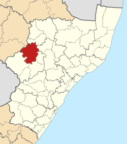
Nkandla Local Municipality is an administrative area in the King Cetshwayo District of KwaZulu-Natal province in South Africa. The town of Nkandla is the home town of the former President of South Africa, Jacob Zuma.

uMdoni Local Municipality Local municipality in KwaZulu-Natal, South Africa

uMdoni Local Municipality is an administrative area in the Ugu District of KwaZulu-Natal in South Africa. Umdoni is an isiZulu name for the indigenous tree, Mdoni.

Ngqushwa Local Municipality Local municipality in Eastern Cape, South Africa

Ngqushwa Local Municipality is an administrative area in the Amatole District of the Eastern Cape in South Africa.

Umzimvubu Local Municipality Local municipality in Eastern Cape, South Africa

Umzimvubu Local Municipality is an administrative area in the Alfred Nzo District of Eastern Cape in South Africa.

uMuziwabantu Local Municipality Local municipality in KwaZulu-Natal, South Africa

uMuziwabantu Local Municipality is an administrative area in the Ugu District of KwaZulu-Natal in South Africa.

Umzumbe Local Municipality Local municipality in KwaZulu-Natal, South Africa

Umzumbe Local Municipality is an administrative area in the Ugu District of KwaZulu-Natal in South Africa.

Lukhanji Local Municipality Former local municipality in Eastern Cape, South Africa

Lukhanji Local Municipality was an administrative area in the Chris Hani District of the Eastern Cape in South Africa. Lukhanji is a Xhosa name for the mountain that runs from the eastern side of Queenstown to the western side. After municipal elections on 3 August 2016 it was merged into the larger Enoch Mgijima Local Municipality.

Imbabazane Local Municipality Local municipality in KwaZulu-Natal, South Africa

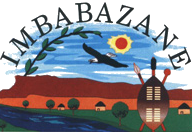
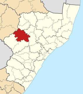
Imbabazane Local Municipality was an administrative area in the Uthukela District of KwaZulu-Natal in South Africa. Imbabazane is the name of an African tree. After municipal elections on 3 August 2016 it was merged into the larger Inkosi Langalibalele Local Municipality.

Walter Sisulu Local Municipality Local municipality in Eastern Cape, South Africa

Walter Sisulu Local Municipality is an administrative area in the Joe Gqabi District of the Eastern Cape in South Africa. The municipality was formed by the merging of Maletswai and Gariep Local Municipality immediately after the August 2016 Local Municipal Elections.

Alfred Duma Local Municipality Local municipality in KwaZulu-Natal, South Africa

Alfred Duma Local Municipality is a local municipality of South Africa. It was established for the August 2016 local elections by the merging of Emnambithi/Ladysmith and Indaka local municipalities.

References

  1. "Contact list: Executive Mayors". Government Communication & Information System. Archived from the original on 14 July 2010. Retrieved 22 February 2012.
  2. 1 2 3 "Statistics by place". Statistics South Africa. Retrieved 27 September 2015.
  3. Integrated Development Plan 2007/2008. Emnambithi-Ladysmith Municipality. Retrieved on Oct 10, 2009.
  4. Lookup Tables - Statistics South Africa [ permanent dead link ]
  5. "Results Summary – All Ballots: Emnambithi/Ladysmith" (PDF). Independent Electoral Commission. Retrieved 3 December 2013.
  6. "Seat Calculation Detail: Emnambithi/Ladysmith" (PDF). Independent Electoral Commission. Retrieved 3 December 2013.