Moorhead Township is a township in Clay County, Minnesota, United States. The population was 184 at the 2020 census.
Jenkins Township is a township in Crow Wing County, Minnesota, United States. The population was 425 at the 2000 census.
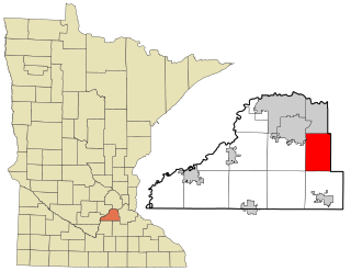
Iron Range Township was a township in Itasca County, Minnesota, United States. The population was 649 at the 2010 census.
Wright Township is a township in Marshall County, Minnesota, United States. The population was 126 at the 2000 census.
Bergen Township is a township in McLeod County, Minnesota, United States. The population was 910 at the 2020 census.
Collins Township is a township in McLeod County, Minnesota, United States. The population was 436 at the 2020 census.
Hutchinson Township is a township in McLeod County, Minnesota, United States. The population was 1,215 at the 2020 census.
Pine City Township is a township in Pine County, Minnesota, United States, located south and east of the city of Pine City. The township population was 1,249 at the 2000 census.
Credit River is a city in Scott County, Minnesota, United States. The population was 5,493 at the 2020 census.
Livonia Township is a township in Sherburne County, Minnesota, United States. The population was 3,917 at the 2000 census.
Orrock Township is a township in Sherburne County, Minnesota, United States. The population was 2,764 at the 2000 census.
Palmer Township is a township in Sherburne County, Minnesota, United States. The population was 2,414 at the 2000 census.

Roscoe is a city in Stearns County, Minnesota, United States. The population was 102 at the 2010 census. It is part of the St. Cloud Metropolitan Statistical Area. On December 7, 2016, Donald Kennith Albrecht was sworn in as mayor of Roscoe.
Summit Township is a township in Steele County, Minnesota, United States. The population was 515 at the 2000 census.
Hartford Township is a township in Todd County, Minnesota, United States. The population was 677 at the 2000 census. By the 2020 census the population had declined to 644 inhabitants.
Moran Township is a township in Todd County, Minnesota, United States. The population was 515 at the 2000 census. By the 2020 census the population had declined to 489.
Leaf River Township is a township in Wadena County, Minnesota, United States. The population was 515 at the 2000 census.

Black Lick Township is a township in Indiana County, Pennsylvania, United States. The population was 1,133 at the 2020 census. The township includes the communities of Grafton, Jacksonville, and Newport.

Sandy Lake Township is a township that is located in Mercer County, Pennsylvania, United States. The population was 1,197 at the time of the 2020 census, a decline from the figure of 1,226 that was documented in 2010.

Minneiska is a city in Wabasha and Winona counties in the U.S. state of Minnesota. The population was 97 at the 2020 census.


