Kalgoorlie is a city in the Goldfields–Esperance region of Western Australia, located 595 km (370 mi) east-northeast of Perth at the end of the Great Eastern Highway. It is sometimes referred to as Kalgoorlie–Boulder, as the surrounding urban area includes the historic townsite of Boulder and the local government area is the City of Kalgoorlie–Boulder.

Wiluna is a small town in the Goldfields-Esperance region of Western Australia. It is situated on the edge of the Western Desert at the gateway to the Canning Stock Route and Gunbarrel Highway. It is the service centre of the local area for the local Martu people, the pastoral industry, the Wiluna Gold Mine, and many more people who work on other mines in the area on a "fly-in/fly-out" basis. Wiluna's climate is hot and dry, with an annual rainfall of 258 millimetres (10.2 in). Mean maximum temperatures range from 19 °C (66 °F) in July, to 38 °C (100 °F) in January.
The Pilbara is a large, dry, thinly populated region in the north of Western Australia. It is known for its Aboriginal peoples; its ancient landscapes; the red earth; and its vast mineral deposits, in particular iron ore. It is also a global biodiversity hotspot for subterranean fauna.

Stawell ( "stall"), is an Australian town in the Wimmera region of Victoria 237 kilometres (147 mi) west-north-west of the state capital, Melbourne. Located within the Shire of Northern Grampians local government area, it is a seat of local government for the shire and its main administrative centre. At the 2021 census, Stawell had a population of 6,220.

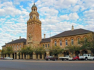
Cobar is a town in central western New South Wales, Australia whose economy is based mainly upon base metals and gold mining. The town is 712 km (442 mi) by road northwest of the state capital, Sydney. It is at the crossroads of the Kidman Way and Barrier Highway. The town and the local government area, the Cobar Shire, are on the eastern edge of the outback. At the 2016 census, the town of Cobar had a population of 3,990. The Shire has a population of approximately 4,700 and an area of 44,065 square kilometres (17,014 sq mi).

Westonia is a small town located in the eastern Wheatbelt region of Western Australia, 10 kilometres (6 mi) north of the Great Eastern Highway. It is the main town in the Shire of Westonia.

Collie is a town in the South West region of Western Australia, 213 kilometres (132 mi) south of the state capital, Perth, and 59 kilometres (37 mi) inland from the regional city and port of Bunbury. It is near the junction of the Collie and Harris Rivers, in the middle of dense jarrah forest and the only coalfields in Western Australia. At the 2021 census, Collie had a population of 7,599.
Koolyanobbing is located 54 km (34 mi) north-northeast of the town of Southern Cross, Western Australia. Iron ore has been mined here since 1948 by a series of companies, with a break between 1983 and 1993. The ore is currently railed to the port at Esperance for export. The current owner and operator of the lease is Mineral Resources Limited.

The Perth Mint is Australia's official bullion mint and wholly owned by the Government of Western Australia. Established on 20 June 1899, two years before Australia's Federation in 1901, the Perth Mint was the last of three Australian colonial branches of the United Kingdom's Royal Mint intended to refine gold from the gold rushes and to mint gold sovereigns and half-sovereigns for the British Empire. Along with the Royal Australian Mint, which produces coins of the Australian dollar for circulation, the Perth Mint is the older of Australia's two mints issuing coins that are legal tender.
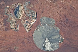
Mount Keith Mine is an open pit nickel mine in Western Australia. It is operated by BHP. The site's closest landmark is the town of Wiluna, 85 km (53 mi) to the north.

The Gold Stealing Detection Unit (GSDU), or Gold Stealing Detective Squad (GSDS), is a special unit of the Western Australian Police, based in Kalgoorlie, Western Australia. It investigates criminal activity and allegations at all stages of the gold production process in the state.
The Agnew Gold Mine, formerly the Emu Mine, is a gold mine located 3 km (1.9 mi) west of Agnew, Western Australia. It is owned by the South African mining company Gold Fields. As of 2022, it is one of four mines the company operates in Australia, the others being the Granny Smith Gold Mine, St Ives Gold Mine and the Gruyere Gold Mine.
The Central Norseman gold mine is located at Norseman, Western Australia. Norseman lies at the southern end of the Norseman-Wiluna Greenstone Belt, in the Eastern Goldfields Province of the Yilgarn Block, Western Australia.

Gold mining in Western Australia is the third largest commodity sector in Western Australia (WA), behind iron ore and LNG, with a value of A$17 billion in 2021–22. The 6.9 million troy ounces sold during this time period was the highest amount in 20 years and accounted for almost 70 percent of all gold sold in Australia.
The Edna May Gold Mine is a gold mine located at Westonia, Western Australia.

Canbelego is a village in the Orana region of New South Wales, Australia. It is now virtually a ghost town but was once a much larger settlement associated with the Mount Boppy Gold Mine. The name also refers to the surrounding rural locality identified for postal and statistical purposes. At the 2021 census, the population of Canbelego, including its surrounding area, was 54, up from 39 in 2016, but the village itself had only four residents in early 2020. Between 1907 and 1917, the population was around 2,000.
Regis Resources is an Australian-based, Australian Securities Exchange-listed (ASX) gold producer and explorer based in Subiaco, Western Australia.
Westgold Resources is an Australian-based, Australian Securities Exchange-listed (ASX) gold producer and explorer based in Perth, Western Australia.

Wrightville was a mining village in the Orana region of New South Wales, Australia. Once it was a significant settlement, with its own municipal government, public school, convent school, post office, police station, four hotels, and railway connection. At its peak, around 1907, its population probably reached 2,000 people. Its site and that of the adjacent former village of Dapville are now an uninhabited part of Cobar.
