Related Research Articles

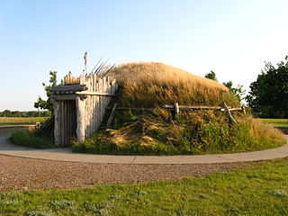
Pipestone National Monument is located in southwestern Minnesota, just north of the city of Pipestone, Minnesota. It is located along the highways of U.S. Route 75, Minnesota State Highway 23 and Minnesota State Highway 30. The quarries are sacred to many tribal nations of North America, including the Dakota, Lakota, and other tribes of Native Americans, and were considered neutral territory in the historic past where all Nations could quarry stone for ceremonial pipes. The catlinite, or "pipestone" is traditionally used to make ceremonial pipes, vitally important to traditional Plains Indian religious practices. Archeologists believe the site has been in use for over 3000 years with Minnesota pipestone having been found inside North American burial mounds dated much earlier.

The Jeffers Petroglyphs site is an outcrop in southwestern Minnesota with pre-contact Native American petroglyphs. The petroglyphs are pecked into rock of the Red Rock Ridge, a 23-mile (37 km)-long Sioux quartzite outcrop that extends from Watonwan County, Minnesota to Brown County, Minnesota. The exposed surface is approximately 150 by 650 feet and surrounded by virgin prairie. "The site lies in an area inhabited in the early historic period by the Dakota Indians, and both the style and form of some of the carvings are identical with motifs that appear on Dakota hide paintings and their quill designs and beadwork. Others are foreign to this Plains Indian tradition and seem to be much earlier in origin." Several old wagon trail ruts traverse the site, one of which is believed to be the old stage coach route from New Ulm, Minnesota to Sioux Falls, South Dakota.

Fort Union Trading Post National Historic Site is a partial reconstruction of the most important fur trading post on the upper Missouri, 1829-1867. The fort site is about two miles from the confluence of the Missouri River and its tributary, the Yellowstone River, on the Dakota side of the North Dakota/Montana border, 25 miles from Williston, North Dakota.
The Knife River Indian Villages National Historic Site, which was established in 1974, preserves the historic and archaeological remnants of bands of Hidatsa, Northern Plains Indians, in North Dakota. This area was a major trading and agricultural area. Three villages were known to occupy the Knife area. In general, these three villages are known as Hidatsa villages. Broken down, the individual villages are Awatixa Xi'e, Awatixa and Big Hidatsa village. Awatixa Xi'e is believed to be the oldest village of the three. The Big Hidatsa village was established around 1600.

Fort Ridgely State Park is a state park of Minnesota, USA, on the Minnesota River south of Fairfax. It preserves Fort Ridgely, site of the Battle of Fort Ridgely during the Dakota War of 1862. It was the only Minnesota state park with a 9-hole golf course, which overlooks the Minnesota River and goes along Fort Ridgely Creek.

Fort Abercrombie, in North Dakota, was an American fort established by authority of an act of Congress, March 3, 1857. The act allocated twenty-five square miles of land on the Red River of the North in Dakota Territory to be used for a military outpost, but the exact location was left to the discretion of Lieutenant Colonel John J. Abercrombie. The fort was constructed in the year 1858. It was the first permanent military settlement in what became North Dakota, and is thus known as "The Gateway to the Dakotas".

The Arzberger Site, designated by archaeologists with the Smithsonian trinomial 39HU6, is a major archaeological site in Hughes County, near Pierre, South Dakota. It was declared a National Historic Landmark in 1964. It is a large fortified village, that is the type site for the Initial Coalescent, a culture that flourished in the area c. 1200-1350 CE.

The Sioux Quartzite is a Proterozoic quartzite that is found in the region around the intersection of Minnesota, South Dakota, and Iowa, and correlates with other rock units throughout the upper midwestern and southwestern United States. It was formed by braided river deposits, and its correlative units are thought to possibly define a large sedimentary wedge that once covered the passive margin on the then-southern side of the North American craton. In human history, it provided the catlinite, or pipestone, that was used by the Plains Indians to carve ceremonial pipes. With the arrival of Europeans, it was heavily quarried for building stone, and was used in many prominent structures in Sioux Falls, South Dakota and shipped to construction sites around the Midwest. Sioux Quartzite has been and continues to be quarried in Jasper, Minnesota at the Jasper Stone Company and Quarry, which itself was posted to the National Register of Historic Places on January 5, 1978. Jasper, Minnesota contains many turn-of-the-century quartzite buildings, including the school, churches and several other public and private structures, mostly abandoned.

This is a list of the National Register of Historic Places listings in Grand Forks County, North Dakota. This is intended to be a complete list of the properties and districts on the National Register of Historic Places in Grand Forks County, North Dakota, United States. The locations of National Register properties and districts for which the latitude and longitude coordinates are included below, may be seen in an online map.

The Telephone Co. Building in Grand Forks, North Dakota, United States, was built in 1904. It was listed on the National Register of Historic Places in 1982.

The Edgar Building is a building in Grand Forks, North Dakota that was listed on the National Register of Historic Places in 1983. Its construction date is unclear.
Four historic sites within the Holy Trinity Cemetery near Strasburg, North Dakota, United States, identified as Holy Trinity Cemetery, Wrought-Iron Cross Site A, as Holy Trinity Cemetery, Wrought-Iron Cross Site B, and likewise for Site C and Site D, were listed on the National Register of Historic Places in 1989. They include wrought-iron crosses. The listing for Site A included 9 contributing objects and work by Deport Schneider and Jake Schneider. The listing for Site B included 3 contributing objects and work by Simon Marquardt and Michael Schmidt. Site C included just one contributing object, dating from 1912. Site D included just one.
St. Mary's Church Non-contiguous Historic District is a historic district near Hague, North Dakota, United States. The church was founded by immigrants who were Germans from Russia.
The High Butte Effigy and Village Site (32ME13) is an ancient Native American ceremonial site near the Garrison Dam and Riverdale, North Dakota. The site was listed on the National Register of Historic Places in 1978. It is located atop a butte and includes a "turf cut turtle effigy." Items recovered from the site include 14 points, 24 body sherds, five rim sherds, and a grooved paddle.

John Brown Farm, Tannery & Museum, 17620 John Brown Rd., Guys Mills, PA 16327, is a historic archaeological site located in Richmond Township, Crawford County, Pennsylvania. The tannery was built in 1825 by famed abolitionist John Brown (1800–1859), who lived on the site from 1825 to 1835. The tannery was about 0.25 miles (0.40 km) from the new Pennsylvania and Ohio Canal.
The Cooper Village Archeological Site, designated 39SL15, encompasses what is believed to be a prehistoric Native American village in Sully County, South Dakota. It is located on a peninsula projecting into Lake Oahe, and portions of it were identified in 1979 and 1982 as being subjected to shoreline erosion by the lake. It is described as a small village, with four depressions identified as being consistent with dwellings, and a low mound, with occupancy believed to c. 1550-1675 CE, based on artifacts found at the site.
The Carson Mounds,, also known as the Carson Site and Carson-Montgomery- is a large Mississippian culture archaeological site located near Clarksdale in Coahoma County, Mississippi in the Yazoo Basin. Only a few large earthen mounds are still present at Carson to this day. Archaeologists have suggested that Carson is one of the more important archaeological sites in the state of Mississippi.

The Evans Block, also known as Northwestern National Bank Building, is a historic building located in Sioux City, Iowa, United States. The city experienced a building boom that began in the late 1880s and continued into the early 1890s. Fred T. Evans, an entrepreneur who had business interests in Iowa, Nebraska and South Dakota, had this building constructed to house Northwestern National Bank of which he was the president. The bank occupied the main level and other offices were housed on the upper floors. Local architect Charles Brown designed the four-story Romanesque Revival style building. The Black Hills sandstone for the public facades was from Evans' quarry. The Panic of 1893 brought Sioux City's building boom to an end, and the Evans block was sold in January 1895. Subsequently, the building has housed a hotel, a factory, a saloon, and a variety of stores. It was individually listed on the National Register of Historic Places in 1985, and as a contributing property in the Fourth Street Historic District in 1995.

The Brown County Courthouse is a historic courthouse in Aberdeen, the county seat of Brown County, South Dakota. It was built in 1904 and is listed on the National Register of Historic Places.
References
- 1 2 "National Register Information System". National Register of Historic Places . National Park Service. July 9, 2010.
- ↑ Fred E. Schneider & Jeff Kinney (1978). Evans: A Multi-Component Site in Northwestern North Dakota. Archeology in Montana, Vol. 19, Nos. 1-2. pp. 15–24.
- ↑ John C. Whitehurst; James C. Dahlberg; et al. (March 1989). "A Class II Cultural Resource Inventory of a Portion of the Upper Souris River Valley, North Dakota" (PDF). Cultural Research & Management, Inc. pp. 18, 132, 143, 148, 150. Archived from the original on April 8, 2013.
- ↑ Trevor Richard Peck (2010). Light from Ancient Campfires: Archaeological Evidence for Native Lifeways. Athabasca University Press. p. 362. ISBN 1897425961.
| Topics | |
|---|---|
| Lists by state |
|
| Lists by insular areas | |
| Lists by associated state | |
| Other areas | |
| Related | |