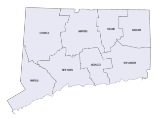
This is a list of properties and districts listed on the National Register of Historic Places in Connecticut. There are more than 1,500 listed sites in Connecticut. All 8 counties in Connecticut have listings on the National Register.

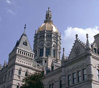
George Keller, was an American architect and engineer. He enjoyed a diverse and successful career, and was sought for his designs of bridges, houses, monuments, and various commercial and public buildings. Keller's most famous projects, however, are the Soldiers and Sailors Memorial Arch in Hartford, Connecticut, and the James A. Garfield Memorial in Cleveland, Ohio.
The neighborhoods of Hartford, Connecticut in the United States are varied and historic.

Cedar Hill Cemetery in Hartford, Connecticut is located at 453 Fairfield Avenue. It was designed by landscape architect Jacob Weidenmann (1829–1893) who also designed Hartford's Bushnell Park. Its first sections were completed in 1866 and the first burial took place on July 17, 1866. Cedar Hill was designed as an American rural cemetery in the tradition of Mount Auburn Cemetery in Cambridge, Massachusetts.

The Howard Avenue Historic District is a 32-acre (13 ha) historic district in The Hill neighborhood of the city of New Haven, Connecticut. Extending along Howard Avenue between Minor Street and Interstate 95, it contains an unusually high concentration of well-preserved late 19th-century middle class vernacular architecture, reflecting the area's growth at that time. It was listed on the National Register of Historic Places in 1985.
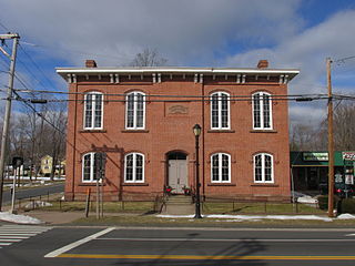
The Hazardville Historic District is a historic district in the Hazardville section of Enfield, Connecticut, United States, that is listed on the National Register of Historic Places.

The Southport Historic District in the town of Fairfield, Connecticut is a 225-acre (91 ha) area historic district that was listed on the National Register of Historic Places in 1971. It preserves a portion of the modern neighborhood and former borough of Southport, Connecticut. Since the British burnt almost all of Southport's structures in 1779, there is only one home built prior to that date, the Meeker House at 824 Harbor Road, which survives.

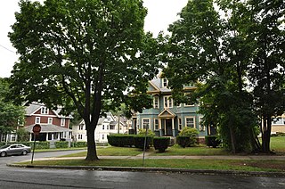
The West End South Historic District encompasses a neighborhood of mid 19th to early 20th century residential architecture in western Hartford, Connecticut and eastern West Hartford, Connecticut. Roughly bounded by Prospect and South Whitney Streets, West Boulevard, and Farmington Avenue, the area includes a large number of Colonial Revival and Queen Anne houses, as well as numerous buildings in other period styles, with only a small number of losses. It was listed on the National Register of Historic Places in 1985.
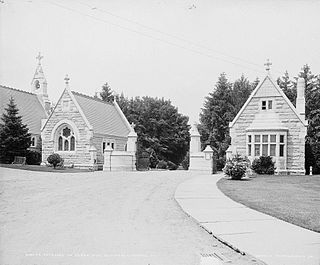
Northam Memorial Chapel and Gallup Memorial Gateway, also known as Cedar Hill Chapel and Gateway, are a historic chapel and gateway in the Cedar Hill Cemetery at 453 Fairfield Avenue in Hartford, Connecticut, USA. Although not part of that cemetery's original rural cemetery design, they are a prominent work of architect George Keller, designed in 1882 and completed in 1889. The Gothic Revival structures were listed on the National Register of Historic Places in 1982.
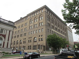
The Elm Street Historic District encompasses a collection of architecturally distinguished institutional and residential buildings near the Connecticut State Capitol in Hartford, Connecticut. Located on Capitol Avenue and Trinity and Elm Streets, it includes the city's best concentration of early 20th-century architecture, including Bushnell Memorial Hall and several state office buildings. It was listed on the National Register of Historic Places in 1984.
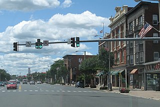
The Downtown Main Street Historic District encompasses a well-preserved historical section of downtown East Hartford, Connecticut. It extends along Main Street from between Burnside Avenue and Governor Street, and along Chapman Street to Chapman Place. Developed between about 1890 and 1945, its architecture encapsulates the town's transition from a main agrarian community to a modern suburb. The district was listed on the National Register of Historic Places in 1996.

Frog Hollow is one of the neighborhoods of Hartford, Connecticut. It is a predominantly working-class residential area, bounded on the north by Capitol Avenue, the east by Lafayette Street, the south by Madison and Hamilton Streets, and on the west by Interstate 84. The neighborhood was developed between about 1850 and 1930, and still contains a remarkable concentration of residential housing from that period. The entire neighborhood, covering more than 150 acres (61 ha) and including more than 900 buildings, is listed on the National Register of Historic Places.

The Asylum Avenue District encompasses the institutional core of the Asylum Hill neighborhood of Hartford, Connecticut. Located just west of Downtown Hartford across Interstate 84, it includes four churches, a school, and a handful of adjacent 19th-century residences. It was listed on the National Register of Historic Places in 1979.

The Capen-Clark Historic District encompasses a residential neighborhood area in the North End of Hartford, Connecticut. Centered on Capen Street between Main and Enfield Streets, it contains a cross-section of post-Civil War Victorian vernacular housing styles, and shows in its development patterns the ebb and flow of the city's economy between about 1865 and 1910. The district was listed on the National Register of Historic Places in 1982.

The Central Avenue-Center Cemetery Historic District encompasses part of the town center of East Hartford, Connecticut. Although it was founded in the mid-17th century, it is now dominated by architecture of the late 19th and early 20th centuries. The Center Cemetery is the town's oldest surviving property, and includes the grave of William Pitkin, a colonial governor. The district, including portions of Main Street and Central Avenue, was listed on the National Register of Historic Places in 1993.

The Jefferson-Seymour District is a historic district encompassing a residential area on the south side of Hartford, Connecticut. Covering portions of Cedar, Wadsworth, Seymour and Jefferson Streets, it contains a well-preserved collection of late 19th and early 20th-century middle-class residential architecture, primarily executed in brick. It was listed on the National Register of Historic Places in 1979.

The West End North Historic District encompasses a neighborhood of late 19th and early 20th century residential architecture in western Hartford, Connecticut and eastern West Hartford, Connecticut. Roughly bounded by Prospect, Elizabeth, and Lorraine Streets and Farmington Avenue, the area includes a large number of Colonial Revival and Queen Anne houses, as well as numerous buildings in other period styles, with only a small number of losses. It was listed on the National Register of Historic Places in 1985.

Parkville is a neighborhood on the west side of Hartford, Connecticut. Centered on Park Street and stretching from the railroad overpass just west of Pope Park to the West Hartford town line, and Capitol Avenue to Interstate 84, Parkville is a densely developed, mixed-use neighborhood that is mainly working-class. Its name is derived from its placement at the junction of the North and South Branches of the now-subterranean Park River. Most of the eastern half of the neighborhood was listed as a historic district on the National Register of Historic Places in 2015.
The Sisson-South Whitney Historic District encompasses a neighborhood in the West End area of Hartford, Connecticut, that was built out between 1890 and 1930 as a streetcar suburb. It is roughly bounded by Farmington Avenue, South Whitney Street, West Boulevard, and Sisson Avenue, and includes a diversity of residential and commercial architecture, reflective of its initial development and subsequent growth. The district was listed on the National Register of Historic Places in 2013.

The Upper Albany Historic District encompasses a predominantly residential area of the North End of Hartford, Connecticut. It extends along Albany Avenue between Garden and Woodland Streets, including side streets to the south, and extends northward to include the southern portion of Keney Park. This area was developed in the first two decades of the 20th century, and has a fine array of period middle-class housing in the Queen Anne and Colonial Revival styles. It was listed on the National Register of Historic Places in 1986.


