
Asia is the largest continent in the world by both land area and population. It covers an area of more than 44 million square kilometers, about 30% of Earth's total land area and 8% of Earth's total surface area. The continent, which has long been home to the majority of the human population, was the site of many of the first civilizations. Its 4.7 billion people constitute roughly 60% of the world's population, having more people than all other continents combined.

India, officially the Republic of India, is a country in South Asia. It is the seventh-largest country by area; the most populous country as of June 2023; and from the time of its independence in 1947, the world's most populous democracy. Bounded by the Indian Ocean on the south, the Arabian Sea on the southwest, and the Bay of Bengal on the southeast, it shares land borders with Pakistan to the west; China, Nepal, and Bhutan to the north; and Bangladesh and Myanmar to the east. In the Indian Ocean, India is in the vicinity of Sri Lanka and the Maldives; its Andaman and Nicobar Islands share a maritime border with Thailand, Myanmar, and Indonesia.

India is the most populous country in the world with one-sixth of the world's population. According to the UN estimates, India has overtaken China in having the largest population in the world with population of 1,425,775,850 at the end of April 2023.

Kashmir is the northernmost geographical region of the Indian subcontinent. Until the mid-19th century, the term "Kashmir" denoted only the Kashmir Valley between the Great Himalayas and the Pir Panjal Range. Today, the term encompasses a larger area that includes the India-administered territories of Jammu and Kashmir and Ladakh, the Pakistan-administered territories of Azad Kashmir and Gilgit-Baltistan, and the Chinese-administered territories of Aksai Chin and the Trans-Karakoram Tract.

Maharashtra is a state in the western peninsular region of India occupying a substantial portion of the Deccan Plateau. It is bordered by the Arabian Sea to the west, the Indian states of Karnataka and Goa to the south, Telangana to the southeast and Chhattisgarh to the east, Gujarat and Madhya Pradesh to the north, and the Indian union territory of Dadra and Nagar Haveli and Daman and Diu to the northwest. Maharashtra is the second-most populous state in India and the third-most populous country subdivision globally.

Rajasthan is a state in northern India. It covers 342,239 square kilometres (132,139 sq mi) or 10.4 per cent of India's total geographical area. It is the largest Indian state by area and the seventh largest by population. It is on India's northwestern side, where it comprises most of the wide and inhospitable Thar Desert and shares a border with the Pakistani provinces of Punjab to the northwest and Sindh to the west, along the Sutlej-Indus River valley. It is bordered by five other Indian states: Punjab to the north; Haryana and Uttar Pradesh to the northeast; Madhya Pradesh to the southeast; and Gujarat to the southwest. Its geographical location is 23°.3' to 30°.12' North latitude and 69°.30' to 78°.17' East longitude, with the Tropic of Cancer passing through its southernmost tip.

West Bengal is a state in the eastern portion of India. It is situated along the Bay of Bengal, along with a population of over 91 million inhabitants within an area of 88,752 km2 (34,267 sq mi) as of 2011. The population estimate as of 2023 is 102,552,787. West Bengal is the fourth-most populous and thirteenth-largest state by area in India, as well as the eighth-most populous country subdivision of the world. As a part of the Bengal region of the Indian subcontinent, it borders Bangladesh in the east, and Nepal and Bhutan in the north. It also borders the Indian states of Jharkhand, Odisha, Bihar, Sikkim and Assam. The state capital is Kolkata, the third-largest metropolis, and seventh largest city by population in India. West Bengal includes the Darjeeling Himalayan hill region, the Ganges delta, the Rarh region, the coastal Sundarbans and the Bay of Bengal. The state's main ethnic group are the Bengalis, with the Bengali Hindus forming the demographic majority.

Kolkata is the capital and largest city of the Indian state of West Bengal. It lies on the eastern bank of the Hooghly River, 80 km (50 mi) west of the border with Bangladesh. It is the financial center of eastern and northeastern India. According to the 2011 Indian census, Kolkata is the seventh-most populous city in India, with a population of 4.5 million residents within its city proper. Greater Kolkata has a population of 15 million residents, and is the third-largest urban area in India. Kolkata is a historically and culturally significant city in the historic region of Bengal. It is the second largest Bengali-speaking city.
Uttar Pradesh is a state in northern India. With over 241 million inhabitants, it is the most populated state in India as well as the most populous country subdivision in the world – more populous than all but three other countries outside of India. – accounting for 16.5% of the total population of India. It was established in 1950 after India had become a republic. It is a successor to the United Provinces, established in 1935 by renaming of the United Provinces of Agra and Oudh, in turn established in 1902 from the North-Western Provinces and the Oudh Province. Lucknow serves as the state capital, with Prayagraj being the judicial capital.

The Partition of India in 1947 was the change of political borders and the division of other assets that accompanied the dissolution of the British Raj in the Indian subcontinent and the creation of two independent dominions in South Asia: India and Pakistan. The Dominion of India is today the Republic of India, and the Dominion of Pakistan—which at the time comprised two regions lying on either side of India—is now the Islamic Republic of Pakistan and the People's Republic of Bangladesh. The partition was outlined in the Indian Independence Act 1947. The change of political borders notably included the division of two provinces of British India, Bengal and Punjab. The majority Muslim districts in these provinces were awarded to Pakistan and the majority non-Muslim to India. The other assets that were divided included the British Indian Army, the Royal Indian Navy, the Royal Indian Air Force, the Indian Civil Service, the railways, and the central treasury. Provisions for self-governing independent Pakistan and India legally came into existence at midnight on 14 and 15 August 1947 respectively.

India is a federal union comprising 28 states and 8 union territories, with a total of 36 entities. The states and union territories are further subdivided into districts and smaller administrative divisions.
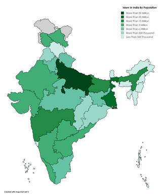
Islam is India's second-largest religion, with 14.2% of the country's population, or approximately 172.2 million people, identifying as adherents of Islam in 2011 Census. India is also the country with the third-largest number of Muslims in the world. The majority of India's Muslims are Sunni, with Shia making up 13% of the Muslim population.
Indian people are the citizens and nationals of the Republic of India. In 2022, the population of India stood at 1.4 billion people. According to UN forecasts, India overtook China as the world's most populous country by the end of April 2023, containing 17.50 percent of the global population. In addition to the Indian population, the Indian overseas diaspora also boasts large numbers, particularly in the Arab states of the Persian Gulf and the Western world. While the demonym "Indian" applies to people originating from the present-day Republic of India, it was also used as the identifying term for people originating from what is now Pakistan and Bangladesh prior to the Partition of India in 1947.

South Asia is the southern subregion of Asia, which is defined in both geographical and ethnic-cultural terms. As commonly conceptualized, South Asia consists of the countries Afghanistan, Bangladesh, Bhutan, India, Maldives, Nepal, Pakistan, and Sri Lanka.

Punjab is a state in northern India. Forming part of the larger Punjab region of the Indian subcontinent, the state is bordered by the Indian states of Himachal Pradesh to the north and northeast, Haryana to the south and southeast, and Rajasthan to the southwest; by the Indian union territories of Chandigarh to the east and Jammu and Kashmir to the north. It shares an international border with Punjab, a province of Pakistan to the west. The state covers an area of 50,362 square kilometres, which is 1.53% of India's total geographical area, making it the 19th-largest Indian state by area out of 28 Indian states. With over 27 million inhabitants, Punjab is the 16th-largest Indian state by population, comprising 23 districts. Punjabi, written in the Gurmukhi script, is the most widely spoken and the official language of the state. The main ethnic groups are the Punjabis, with Sikhs (57.7%) and Hindus (38.5%) as the dominant religious groups. The state capital is Chandigarh, a union territory and also the capital of the neighbouring state of Haryana. Three tributaries of the Indus, viz., Sutlej, Beas, and Ravi, flow through Punjab.

The 2011 Census of India or the 15th Indian Census was conducted in two phases, house listing and population enumeration. The House listing phase began on 1 April 2010 and involved the collection of information about all buildings. Information for National Population Register (NPR) was also collected in the first phase, which will be used to issue a 12-digit unique identification number to all registered Indian residents by Unique Identification Authority of India. The second population enumeration phase was conducted between 9 and 28 February 2011. Census has been conducted in India since 1872 and 2011 marks the first time biometric information was collected. According to the provisional reports released on 31 March 2011, the Indian population increased to 1.21 billion with a decadal growth of 17.70%. Adult literacy rate increased to 74.04% with a decadal growth of 9.21%. The motto of the census was Our Census, Our Future.

Bangalore, officially Bengaluru, is the capital and largest city of the southern Indian state of Karnataka. It has a population of more than 8 million and a metropolitan population of around 11 million, making it India's third most populous city and fifth most populous urban agglomeration, as well as South India's second-largest urban agglomeration, and the 27th largest city in the world. Located on the Deccan Plateau, at a height of over 900 m (3,000 ft) above sea level, Bangalore has a pleasant climate throughout the year, with its parks and green spaces earning it the reputation of India's "Garden City". Its elevation is the highest among India's major cities.