
Uttara Kannada, formerly known as North Canara, is a district in the Indian state of Karnataka. Uttara Kannada District is a major coastal district of Karnataka, with the largest coastal district. It is bordered by the state of Goa and Belagavi District to the north, Dharwad District and Haveri District to the east, Shivamogga District, and Udupi District to the south, and the Arabian Sea to the west.

Karwar is a city, taluk and administrative center of Uttara Kannada district in the Indian state of Karnataka, which lies on the west coast of Southern India at the mouth of the Kali river.
Ankola is a Town Municipal Council and a taluka in Uttara Kannada district of the Indian state of Karnataka. The name of the place is derived from a forest shrub Ankola grown on the coastal hill side and worshiped by the Halakki Vokkaligas as a totem. The town is around 33 km (21 mi) from Karwar and 57 km (35 mi) from Bhatkal.
Dandeli is a taluk in Uttara Kannada district of Karnataka, India, in the Western Ghats region.

Sirsi is a moderate city in Uttara Kannada district, Karnataka, India. Sirsi was also known as Kalyanapattana during the Sonda Dynasty.

North Karnataka, is a geographical region in Deccan plateau from 300 to 730 metres elevation that constitutes the region of the Karnataka state in India and the region consists of 13 districts. It is drained by the Krishna River and its tributaries the Bhima, Ghataprabha, Malaprabha, and Tungabhadra. North Karnataka lies within the Deccan thorn scrub forests ecoregion, which extends north into eastern Maharashtra. Most parts of the region has black fertile soil ideal for agriculture.
Dharwad is an administrative district of the state of Karnataka in southern India.
Haliyal is a town in Uttara Kannada in the Indian state of Karnataka. It is the headquarters town for Haliyal Taluk. It can be classified as a main-road town.
Londa is a census town in Belagavi district in the Indian state of Karnataka.The town is on border with state of Goa. The town is surrounded by lush evergreen forests known as Sahayadri or Western ghats of India. Londa is situated at the border of Belagavi district with Uttara Kannada district. Londa Junction railway station is located on the Belgaum - Goa and Goa to Dharwad railway route. Since it is a junction of two railway routes, Many tourists alight here to visit nearby forests of Kali Tiger Reserve. Londa is also connected by National Highway 748 connecting Goa to Belagavi via Anmod ghat. It is also connected to Uttara Kannada district headquarters Karwar by Karnataka state highway 34 (SH34)via Hankon, Kumbarwada, Anshi, Joida, Ganeshgudi and Ramnagar. Londa is connected by National highway 67 coming from Hubballi and Dharwar.
Karnataka, the sixth largest state in India, has been ranked as the third most popular state in the country for tourism in 2014. It is home to 507 of the 3600 centrally protected monuments in India, the largest number after Uttar Pradesh. The State Directorate of Archaeology and Museums protects an additional 752 monuments and another 25,000 monuments are yet to receive protection. Tourism centres on the ancient sculptured temples, modern cities, the hill ranges, forests and beaches. Broadly, tourism in Karnataka can be divided into four geographical regions: North Karnataka, the Hill Stations, Coastal Karnataka and South Karnataka.
Ulavi is a village in the Uttara Kannada district in the Indian state of Karnataka. Ulavi is a village about 75 kilometres (47 mi) from Karwar in Karnataka state, India.
Yellapura is a town in the Uttara Kannada district of Karnataka, India. It is a major trading centre for Arecanut, which is the primary crop grown in the villages surrounding the city. Approximately 90% of the population of Yellapura are farmers who grow Arecanut and paddy.
Joida is a town located in the Uttar Kannada district in the Indian state of Karnataka. The town is the headquarters of the eponymous taluk.

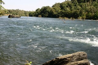
The Kali River or Kaali Nadi is a river flowing through Uttara Kannada district of Karnataka state in India. The river rises near Kushavali, a small village in Uttar Kannada district. The river is the lifeline to some 400,000 people in the Uttara Kannada district and supports the livelihoods of tens of thousands of people including fishermen on the coast of Karwar. There are many dams built across this river for the generation of electricity. One of the important dams build across Kali river is the Supa Dam at Ganeshgudi. The river runs 184 kilometers before joining Arabian Sea.
Kalas is a village in the southern state of Karnataka, India. It is located in the Kundgol taluk of Dharwad district in Karnataka. This is the native place of Guru Govindabhatta, who is the guru of Santha Shishunal Sharif. Today we can find Samadhi of Guru Govindabhatta here. His aradhana takes place every year during summer.
Shelawadi or Shelavadi is a panchayat town in the southern state of Karnataka, India. It is located in the Navalgund taluk of Dharwad district in Karnataka.
Shigli is a city located in the Shirhatti taluk of Gadag district in Karnataka. It is situated 52 kilometres (32 mi) to the south of district headquarters Gadag, 26 km (16 mi) from Shirhatti, and 382 km (237 mi) from state capital Bangalore. Shigli's pin code is 582210, and the postal head office is Shigli.
Kerwad (H) is a village in Uttara Kannada in the southwestern India state of Karnataka. The village is 4 kilometres (2.5 mi) by road north of the town of Haliyal.

The following outline is provided as an overview of and topical guide to Karnataka:
Chendia-Todur is a twin village in the Karwar Taluk of Uttar Kannada District of Karnataka. It lies 13 km south of the city of Karwar, 257 km north of the chief port city Mangalore and 489 km from the state capital Bangalore.