
Doab is a term used in South Asia for the tract of land lying between two confluent rivers. It is similar to an interfluve. In the Oxford Hindi-English Dictionary, R. S. McGregor defines it as from Persian do-āb "a region lying between and reaching to the confluence of two rivers."
The administrative divisions of India are subnational administrative units of India; they are composed of a nested hierarchy of administrative divisions.

Rampurhat II is a community development block that forms an administrative division in Rampurhat subdivision of Birbhum district in the Indian state of West Bengal.

Murarai I is a community development block that forms an administrative division in Rampurhat subdivision of Birbhum district in the Indian state of West Bengal.
Aigali is a village in the Athani taluk of Belgaum district, at the southern state of Karnataka, India.
Jugul is a village in the southern state of Karnataka, India. It is located in Athani taluk of Belagavi district in Karnataka.
A tehsil is a local unit of administrative division in India and Pakistan. It is a subdistrict of the area within a district including the designated populated place that serves as its administrative centre, with possible additional towns, and usually a number of villages. The terms in India have replaced earlier terms, such as pargana (pergunnah) and thana.
A village accountant or karanam, patwari, patowary (Assam), talati, lekhpal is a government role in rural areas of the Indian subcontinent. Introduced during the early 16th century, it was maintained by the British Raj. The official, as a representative of the state, is responsible for keeping land records, agricultural records and collecting taxes and acting as the revenue police in certain areas where they were given special jurisdiction.
Alatage is a village in Belgaum district in the southern state of Karnataka, India.
Hidkal is a village in Belgaum district in the southern state of Karnataka, India.
Junjarwad also written as Zunjarwad is a village in Belgaum district in the southern state of Karnataka, India. This is located at a distance of 33km from taluk headquarter Athani. Major occupation of the habitats is agriculture and village has around 3000 acres of agriculture land. Sugar cane is the primary crop. Majority of the villagers belongs to digambarJain religion .Other religions like lingayat, Islam and others are also practiced by villagers

Contai III is a community development block that forms an administrative division in Contai subdivision of Purba Medinipur district in the Indian state of West Bengal.
Khejuri II is a Community Development Block that forms an administrative division in Contai subdivision of Purba Medinipur district in the Indian state of West Bengal.

Kalna I is a community development block that forms an administrative division in Kalna subdivision of Purba Bardhaman district in the Indian state of West Bengal.

Katwa II is a community development block that forms an administrative division in Katwa subdivision of Purba Bardhaman district in the Indian state of West Bengal.

Suri II is a community development block that forms an administrative division in Suri Sadar subdivision of Birbhum district in the Indian state of West Bengal.

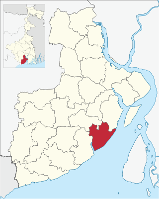
Rajnagar is a community development block that forms an administrative division in Suri Sadar subdivision of Birbhum district in the Indian state of West Bengal.

Nalhati II is a community development block that forms an administrative division in Rampurhat subdivision of Birbhum district in the Indian state of West Bengal.
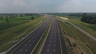
Purvanchal Expressway is a 340.8 km long, 6-lane wide access-controlled expressway in the state of Uttar Pradesh, India. The expressway connects Chand Saray village near Gosainganj in Lucknow district with Haydaria village on NH-31 in Ghazipur district. It is developed by the Uttar Pradesh Expressways Industrial Development Authority (UPEIDA). The Purvanchal Expressway has a 3.2 km long airstrip at Akhalkiri Karwat village near Kurebhar in Sultanpur district for emergency landing of aircraft. The construction work was started by the UPEIDA on 10 October 2018 and was inaugurated and opened to the public on 16 November 2021.

The Panchayat raj is a political system originating from the Indian subcontinent, primarily found in India and neighboring countries Pakistan, Bangladesh, Sri Lanka, and Nepal. It is one of the oldest systems of local government in the Indian subcontinent, with historical mentions dating back to around 250 CE. The word 'raj' means 'rule,' and panchayat' means 'assembly' (ayat) of 'five' (panch). Traditionally, panchayats consisted of wise and respected elders chosen and accepted by the local community. These assemblies resolved disputes between individuals and villages. However, there were various forms of such assemblies.

