
Meghalaya is a state in northeast India. Meghalaya was formed on 21 January 1972 by carving out two districts from the state of Assam: (a) the United Khasi Hills and Jaintia Hills and (b) the Garo Hills. The estimated population of Meghalaya in 2014 was 3,211,474. Meghalaya covers an area of approximately 22,429 square kilometres, with a length-to-breadth ratio of about 3:1.
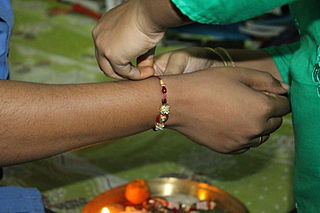
Raksha Bandhan is a popular and traditionally Hindu annual rite or ceremony that is central to a festival of the same name celebrated in the Indian Subcontinent. It is also celebrated in other parts of the world significantly influenced by Hindu culture. On this day, sisters of all ages tie a talisman or amulet called the rakhi around the wrists of their brothers. They symbolically protect them, receive a gift in return, and traditionally invest the brothers with a share of the responsibility of their potential care.
Gram Panchayat is a basic governing institution in Indian villages. It is a political institution, acting as the cabinet of a village or group of villages. The Gram Sabha works as the general body of the Gram Panchayat. The members of the gram panchayat are elected directly by the people. The gram panchayat is headed by an elected President and Vice President, assisted by a Secretary who serves as the administrative head of the panchayat. The president of a gram panchayat is known as a "Pradhan" or "Sarpanch" in Northern India. There are about 250,000 gram panchayats present in India.
The administrative divisions of India are subnational administrative units of India; they are composed of a nested hierarchy of administrative divisions.
A sarpanch, gram pradhan, mukhiya, or president is a decision-maker, elected by the village-level constitutional body of local self-government called the gram sabha in India. The sarpanch, together with other elected panchayat members, constitute gram panchayats and zilla panchayats. The sarpanch is the focal point of contact between government officers and the village community and retains power for five years. the term used to refer to the sarpanch can vary across different states of India. Here are some of the commonly used terms for sarpanch in various states: panchayat president, gram pramukh, gram pradhan, gram adhyaksha, gaon panchayat president, gram panchayat president, etc.

Panchayati raj is the system of local self-government of villages in rural India as opposed to urban and suburban municipalities.
RannaBelagali is a Pattan Panchayat Town in the southern state of Karnataka, India. It is located in the Mudhol taluka of Bagalkot district in Karnataka
Mantur is a village in the southern state of Karnataka, India. It is located in the Mudhol taluk of Bagalkot district in Karnataka.
Nagaral(ನಾಗರಾಳ) is a village in the southern state of Karnataka, India. It is located in the Bilagi taluk of Bagalkot district in Karnataka. It is about 35 kilometres (22 mi) from the district headquarters of Bagalkot town and is about 5 kilometres (3.1 mi) from taluka headquarters of Bilagi and on the left bank of the Krishna River. It is famous for the Digamabareshwara temple and well educated persons.
Darur is a village in the southern state of Karnataka, India. It is located in the Athani Taluk of Belagavi district in Karnataka.
Hulagabali is a village in the southern state of Karnataka, India. It is located in the Athani taluk toward north-east of Belgaum district. The basic occupation in Hulagabali is agriculture and there are also many landlords in the village who are famous in agriculture. Sugarcane is the highest percentage of agriculture as per the survey. There are quite a few temples in the village. The Birappa temple located in this village is well known in surrounding villages. Birappa temple has a large fair and festivities twice a year that draws huge crowd in the region. Sri Sangameshwara temple stands at the juncture of River Krishna and River Agrani. The famous landlords are Patil and Gaddekars.
Nidagundi is a village in the southern state of Karnataka, India. It is located in the Nidagundi taluk of Vijayapur district in Karnataka.
Uchagaon is a village in the southern state of Karnataka, India. It is located in the Belgaum taluk of Belgaum district in Karnataka, and is the last village towards Maharashtra.
A tehsil is a local unit of administrative division in India and Pakistan. It is a subdistrict of the area within a district including the designated populated place that serves as its administrative centre, with possible additional towns, and usually a number of villages. The terms in India have replaced earlier terms, such as pargana (pergunnah) and thana.
Karajgi is a village in northern Karnataka, in central India. Administratively, it is in Afzalpur Taluka of Kalaburagi district in Karnataka.
Ingalagi is a panchayat village in Belgaum district in the southern state of Karnataka, India.
Naganur (K.D.) is a panchayat village in Belgaum district of Karnataka, India.
The Panchayat raj is a political system, originating from the Indian subcontinent, found mainly in India, Pakistan, Bangladesh, Sri Lanka, and Nepal. It is one of the oldest systems of local government in the Indian subcontinent, and historical mentions date to around 250 CE. The word raj means 'rule' and panchayat means 'assembly' (ayat) of 'five' (panch). Traditionally, panchayats consisted of wise and respected elders chosen and accepted by the local community. These assemblies settled disputes between both individuals and villages. However, there were varying forms of such assemblies.
Manko is a village in Jalandhar district of Punjab State, India. It is located 30 kilometres (19 mi) from district headquarter Jalandhar and 156 kilometres (97 mi) from state capital Chandigarh. The village is administered by a sarpanch who is an elected representative of village as per Panchayati raj (India).