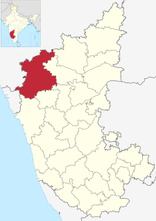
Khanapur is a panchayat town in Belgavi district, Karnataka, India. It is about 26 km from Belagavi. The town is governed by the Khanapur Municipal Council. Khanapur is the headquarters for Khanapur taluk. The town is on the Belgaum-Panaji National Highway, NH 4A. Khanapur is well connected by train and road to important cities in Karnataka, Goa, and Maharashtra. Kannada is the official language but Marathi is widely spoken in the town.
Inchal is a village in the southern state of Karnataka, India. It is located in the Saundatti taluk of Belgaum district in Karnataka.
Itagi is a village in the southern state of Karnataka, India. It is located in the Khanapur taluk of Belgaum district in Karnataka.
U Khanapur is a village in the southern state of Karnataka, India. It is located in the Hukeri taluk of Belgaum district in Karnataka.
Akkiwat is a village in the southern state of Karnataka, India. It is located in the Hukeri taluk of Belgaum district in Karnataka. It is situated 23km away from sub-district headquarter Hukkeri and 58km apart from district headquarter Belgaum. As per 2009 stats, Kesthi is the gram panchayat of Akkiwat village.
Ambewadi is a small Village/hamlet in Khanapur Taluk in Belgaum District of Karnataka State, India. It comes under Ambewadi Panchayath.
Anagadi is a village in Belgaum district in the southern state of Karnataka, India. The official spoken languages of this region include Kannada, Marathi and English
Avarolli is a village in Belgaum district in the southern state of Karnataka, India.
Badachi is a village in Belgaum district in the southern state of Karnataka, India. It is located in Athani Taluka of Belgaum District, near Bijapur -Athani Highway. Maashahibi Darga is situated in the village managed by native Mulla(s) .Allabax S MULLA, Peeralal s mulla, Badashahlal d mulla and every year Maashahibi and Shakarbashah Uras is happen in April or may month,
Dhamne S.Bailur is a village in Belagavi district in the state of Karanataka, India.
Doddahosur is a small village/Hamlet in khanapur taluka in Belgaum district in the southern state of Karnataka,India.Language spoken in Doddahosur is Marathi almost all people speak in Marathi, acspet few people speak in Kannada language.This village comes under Lokoli Gram Panchayath. It belongs to Belgaum Division. It is located 26 km towards South from District headquarters Belgaum. 5 km from Khanapur. This village total population is approx 1000–1200.Most peoples are in Farmers & Teacher and this village having school facility till 7th.
Gudas, Belgaum is a village According to Census 2011 information the location code or village code of Gudas village is 597594. Gudas village is located in Hukeri taluka of Belgaum district in Karnataka, India. It is situated 11km away from sub-district headquarter Hukkeri and 63km away from district headquarter Belgaum. As per 2009 stats, Gudas village is also a gram panchayat.

Honnihalli is a village in Belagavi district in the southern state of Karnataka, India.
Kagganagi is a village in Belgaum district in Karnataka, India.
Karambal is a village in Belgaum district in Karnataka, India. Karambal village is located in Khanapur Tehsil of Belgaum district in Karnataka, India. It is situated 3km away from sub-district headquarter Khanapur and 28km away from district headquarter Belgaum. As per 2009 stats, Karmbla is the gram panchayat of Karambal village. The total geographical area of village is 387.3 hectares. Karambal has a total population of 1,400 peoples. There are about 294 houses in Karambal village. Khanapur is nearest town to Karambal which is approximately 3km away.
Nidagal is a village in Belgaum district of Karnataka, India.
Shippur is a village in Belgaum district of Karnataka, India.
Shivanoor is a village in Belgaum district of Karnataka, India. According to Census 2011 information the location code or village code of Shivanoor village is 597265. Shivanoor village is located in Athni Tehsil of Belgaum district in Karnataka, India. It is situated 13km away from sub-district headquarter Athani and 167km away from district headquarter Belgaum. As per 2009 stats, Jambagi is the gram panchayat of Shivanoor village.
Topinkatti is a village with approx. 5000 population, their native language is Marathi and Kannada. Topinakatti is split in Kannada as Topina and Katti, which means the compound of cannon used in olden times or grove of vegetation. Most peoples are in Indian army and this village having school facility till 10th. This village has gram panchayat serving with other two villages. It's located 10 km away from Khanapur and 26 km away from Belgaum. in Belgaum district of Karnataka, India.
Manjari is a village located in Chikodi Tehsil of Belgaum district in Karnataka, India. It is located 20 km (12 mi) away from sub-district headquarters Chikodi, the nearest town, and 100 km (62 mi) away from district headquarter Belgaum. As per 2009 stats, Manjari village is also a gram panchayat. The total geographical area of village is 555.71 hectares. Manjari has a total population of 8,613 peoples. There are about 1,844 houses in Manjari village.