Farmington | |
---|---|
Coordinates: 47°05′19″N117°02′47″W / 47.08861°N 117.04639°W | |
Country | United States |
State | Washington |
County | Whitman |
First Settled | 1871 |
Founded | 1878 |
Incorporated | 1888 |
Area | |
• Total | 0.36 sq mi (0.94 km2) |
• Land | 0.36 sq mi (0.94 km2) |
• Water | 0.00 sq mi (0.00 km2) |
Elevation | 2,631 ft (802 m) |
Population | |
• Total | 131 |
135 | |
• Density | 419.89/sq mi (162.18/km2) |
Time zone | UTC–8 (Pacific (PST)) |
• Summer (DST) | UTC–7 (PDT) |
ZIP codes | 99104, 99128 |
Area code | 509 |
FIPS code | 53-23340 |
GNIS feature ID | 2412622 [2] |
Website | farmingtonwa.com |
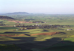
Farmington is a town in Whitman County, Washington, United States. The population was 131 at the 2020 census. [3]
Farmington was laid out in 1878. [5] Farmington was officially incorporated in 1888. At Farmington's peak (1900–1930) the town boasted a population of just under 500. As demand for farm labor decreased, the population and business of the town decreased. Today, Farmington has a population of about 150.
Farmington was settled as Pine Creek, and incorporated as Farmington in 1888, when the population peaked at 1,200. [2]
According to the United States Census Bureau, the town has a total area of 0.34 square miles (0.88 km2), all of it land. [6]
Census | Pop. | Note | %± |
---|---|---|---|
1880 | 76 | — | |
1890 | 418 | 450.0% | |
1900 | 434 | 3.8% | |
1910 | 489 | 12.7% | |
1920 | 479 | −2.0% | |
1930 | 344 | −28.2% | |
1940 | 341 | −0.9% | |
1950 | 239 | −29.9% | |
1960 | 176 | −26.4% | |
1970 | 140 | −20.5% | |
1980 | 176 | 25.7% | |
1990 | 126 | −28.4% | |
2000 | 153 | 21.4% | |
2010 | 146 | −4.6% | |
2020 | 131 | −10.3% | |
2022 (est.) | 135 | [4] | 3.1% |
U.S. Decennial Census [7] 2020 Census [3] |
As of the 2010 census, there were 146 people, 54 households, and 41 families living in the town. The population density was 429.4 inhabitants per square mile (165.8/km2). There were 65 housing units at an average density of 191.2 per square mile (73.8/km2). The racial makeup of the town was 97.3% White and 2.7% Native American. Hispanic or Latino of any race were 2.1% of the population.
There were 54 households, of which 35.2% had children under the age of 18 living with them, 66.7% were married couples living together, 7.4% had a female householder with no husband present, 1.9% had a male householder with no wife present, and 24.1% were non-families. 24.1% of all households were made up of individuals, and 7.5% had someone living alone who was 65 years of age or older. The average household size was 2.70 and the average family size was 3.20.
The median age in the town was 42.3 years. 26% of residents were under the age of 18; 6.2% were between the ages of 18 and 24; 23.9% were from 25 to 44; 27.4% were from 45 to 64; and 16.4% were 65 years of age or older. The gender makeup of the town was 53.4% male and 46.6% female.
As of the 2000 census, there were 153 people, 56 households, and 38 families living in the town. The population density was 445.3 people per square mile (173.7/km2). There were 64 housing units at an average density of 186.3 per square mile (72.7/km2). The racial makeup of the town was 98.04% White, 1.31% Native American and 0.65% Asian. Hispanic or Latino of any race were 5.88% of the population.
There were 56 households, out of which 37.5% had children under the age of 18 living with them, 55.4% were married couples living together, 8.9% had a female householder with no husband present, and 32.1% were non-families. 32.1% of all households were made up of individuals, and 16.1% had someone living alone who was 65 years of age or older. The average household size was 2.73 and the average family size was 3.47.
In the town, the age distribution of the population shows 36.6% under the age of 18, 3.9% from 18 to 24, 20.9% from 25 to 44, 27.5% from 45 to 64, and 11.1% who were 65 years of age or older. The median age was 37 years. For every 100 females, there were 91.3 males. For every 100 females age 18 and over, there were 90.2 males.
The median income for a household in the town was $27,250, and the median income for a family was $39,063. Males had a median income of $41,875 versus $26,250 for females. The per capita income for the town was $13,099. About 8.0% of families and 7.9% of the population were below the poverty line, including none of those under the age of eighteen and 5.9% of those 65 or over.
Farmington is a census-designated place (CDP) in San Joaquin County, California. The population was 172 at the 2020 census, down from 207 at the 2010 census.
Kensington is a census-designated place (CDP) and section of the town of Berlin in Hartford County, Connecticut, United States. The Berlin town offices are located in Kensington. The population was 8,459 at the 2010 census.
Farmington is a city in Van Buren County, Iowa, United States. The population was 579 at the time of the 2020 census.
Avon is a town in Franklin County, Maine, United States. The population was 450 at the 2020 census. Avon is home to Mount Blue, part of Mount Blue State Park.
Albion is a town in Kennebec County, Maine, United States. The population was 2,006 at the 2020 census.
Alna is a town in Lincoln County, Maine, United States. The population was 710 at the 2020 census. Alna is home to the Wiscasset, Waterville and Farmington Railway Museum and is noted for its historic architecture, including the early mill village of Head Tide.
Vermillion is a city in Dakota County, Minnesota, United States. The population was 441 at the 2020 census.
Farmington is a city in St. Francois County located about 75 miles (121 km) southwest of St. Louis in the Lead Belt region in Missouri. As of the 2020 census, the population was 18,217. It is the county seat of St. Francois County. Farmington was established in 1822 as Murphy's Settlement, named for William Murphy of Kentucky, who first visited the site in 1798. When St. Francois County was organized, the town was briefly called St. Francois Court House and later renamed to Farmington.
Naschitti is a census-designated place (CDP) in San Juan County, New Mexico, United States. The population was 360 at the 2000 census. It is part of the Farmington Metropolitan Statistical Area. The town was established in 1886, when Tom Bryan set up a trading post east of the Chuska Mountains. With a Navajo name, Naschitti means "badger springs."
Nenahnezad is a census-designated place (CDP) in San Juan County, New Mexico, United States. The population was 726 at the 2000 census. Nenahnezad is a chapter community just to the south of Fruitland, between the towns of Farmington and Shiprock. It is part of the Farmington Metropolitan Statistical Area.
West Farmington is a village in northwestern Trumbull County, Ohio, United States, along the Grand River. The population was 542 at the 2020 census. It is part of the Youngstown–Warren metropolitan area.
Maineville is a village in Warren County, Ohio, United States. The population was 1,468 as of 2020.
Farmington Township is a township in Tioga County, Pennsylvania, United States. The population was 664 at the 2020 census.
Farmington is a town in Marion County, West Virginia, United States. The population was 389 at the 2020 census. The small town is situated on Buffalo Creek and the Allegheny Mountains about 6 miles west of Fairmont, Marion County's county seat. It is best known for being the site of the 1968 Farmington Mine disaster.
Worthington is a town in Marion County, West Virginia, United States. The population was 158 at the 2010 census. Worthington was incorporated in 1893 and named for Colonel George Worthington, an early settler. U.S. Route 19 passes through the town.
Farmington is a town in Jefferson County, Wisconsin, United States. The population as of the 2010 census was 1,380.
Farmington is a town in La Crosse County, Wisconsin, United States. The population was 2,061 at the 2010 census, up from 1,733 at the 2000 census. It is part of the La Crosse Metropolitan Statistical Area. The unincorporated communities of Burr Oak, Mindoro, and Stevenstown are in the town.
Farmington is a town in Polk County, Wisconsin, United States. The population was 1,625 at the 2000 census. The unincorporated communities of East Farmington and Horse Creek are located in the town.
Farmington is a town in Waupaca County, Wisconsin, United States. The population was 4,148 at the 2000 census. The town includes the census-designated place known as King, and the unincorporated communities of Cobb Town, and Sheridan. The census-designated place of Chain O' Lakes is also located partially in the town.
Farmington is a census-designated place (CDP) comprising the center of the town of Farmington, which is the county seat of Franklin County in Maine, United States. The population of the CDP was 4,288 at the 2010 census, out of 7,760 people in the town as a whole. The University of Maine at Farmington is located within the CDP.