
York County is a county in the eastern part of the Commonwealth of Virginia, located in the Tidewater. As of the 2020 census, the population was 70,045. The county seat is the unincorporated town of Yorktown.

James City County is a county located in the Commonwealth of Virginia. As of the 2020 census, the population was 78,254. Although politically separate from the county, the county seat is the adjacent independent city of Williamsburg.

Manchester is a former independent city in Virginia in the United States. Prior to receiving independent status, it served as the county seat of Chesterfield County, between 1870 and 1876. Today, it is a part of the city of Richmond, Virginia.
The Greater Richmond, Virginia area has many neighborhoods and districts.
Naval Weapons Station Yorktown is a United States Navy base in York County, James City County, and Newport News in the Hampton Roads region of Virginia. It provided a weapons and ammunition storage and loading facility for ships of the United States Atlantic Fleet, and more recently, for those from the Fleet Forces Command.
Fall River is a suburban community located in Nova Scotia, Canada within the Halifax Regional Municipality. It is located north-northeast of the Bedford Basin, northeast of Bedford and Lower Sackville and north of Waverley.
There were several historic mills around the metro Atlanta area, for which many of its current-day roads are still named. Most of the mills date back to the 1820s and 1830s, and were built along the area's many streams. The locations of many of these mills are shown on a map of 1875 showing U. S. military operations around Atlanta in 1864. This map is now located in the U. S. Library of Congress but can be seen on the webpage linked here.
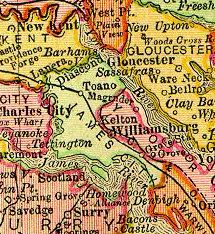
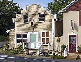
Grove is an unincorporated community in the southeastern portion of James City County in the Virginia Peninsula subregion of Virginia in the United States. It is located in the center of the Historic Triangle of Colonial Virginia, communities linked by the Colonial Parkway. This area is one of the busiest tourist destinations in the world.
Taylorstown is a small community in Loudoun County, Virginia, built on the banks of Catoctin Creek and the surrounding hillside, about two miles (3 km) south of the Potomac River. First settled in 1734, it holds two of the oldest standing houses in Loudoun County, "Hunting Hill" and "Foxton Cottage", directly across the Catoctin Creek from each other.
Tamworth, patented 1728, is an historical hamlet in Cumberland County, Virginia, United States, centered along Tamworth Road. In addition to farming, a gristmill and broad-crested weir on Muddy Creek comprised the principal economic activity. In addition to the mill, there are several other structures of historical interest dating from the 18th and 19th centuries: the miller's residence; a farmhouse; barns; assorted outbuildings; a post office; and Tamworth Cottage. All of the buildings are privately owned and are shown by appointment only.
The Mill Green Historic District is a National Register of Historic Places listed community located in Harford County, Maryland. The district consists of a small cluster of privately owned historic homes and buildings including a historic mill. The district is located at the junction of Mill Green Road and Prospect Road. Broad Creek flows through the district. The historic district designation was established in 1993.

The High Falls Historic District corresponds roughly to the downtown section of the hamlet of that name in Marbletown, New York, United States. It is a 21-acre (8.5 ha) area around the intersection of state highway NY 213, Main Street, Mohonk Road (Ulster County Route 6A0 and Bruceville Road just south of Rondout Creek.

Laurel Mills is an unincorporated community in Rappahannock County, Virginia, United States. It is located in the southern part of the county, approximately halfway between Amissville and Washington. Laurel Mills is located along the Thornton River in Rappahannock County on Route 618, between Viewtown and Rock Mills.
Howardsville is an unincorporated community in Albemarle County, Virginia.
Potterstown is an unincorporated community along the border of Clinton and Readington townships in Hunterdon County, New Jersey.
Millwood Commercial Historic District is a national historic district located at Millwood, Clarke County, Virginia.

Spring Mill is an unincorporated community in Whitemarsh Township, Montgomery County, Pennsylvania, United States.

Old Pine Church, also historically known as Mill Church, Nicholas Church, and Pine Church, is a mid-19th century church located near to Purgitsville, West Virginia, United States. It is among the earliest extant log churches in Hampshire County, along with Capon Chapel and Mount Bethel Church.
The Dennysville Historic District encompasses the historic town center of Dennysville, Maine. Located near the southern end of the large rural community, its architecture covers more than 100 years of community history, from the early 19th to early 20th centuries. The district extends along Main Street between Maine State Route 86 and Bunker Hill Road, on the west bank of the Dennys River. It was listed on the National Register of Historic Places in 1982.


