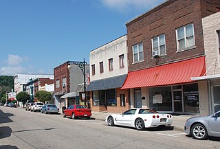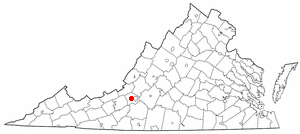
Covington is an independent city in the Commonwealth of Virginia. As of the 2010 census, the population was 5,961, making it the third-least populous city in Virginia. It is surrounded by Alleghany County, of which it is also the county seat. Located at the confluence of Jackson River and Dunlap Creek, Covington is one of three cities in the Roanoke Regional Partnership. The Bureau of Economic Analysis combines the city of Covington with Alleghany county for statistical purposes.

Elliston is a census-designated place (CDP) in Montgomery County, Virginia, United States. It lies between the city of Roanoke and the town of Christiansburg in the southwestern part of the state. The population as of the 2010 Census was 902. It is home to a small fire department, an elementary school, two gas stations, a train stop, and several churches. Most of its residents commute to larger towns. A set of railroad tracks separates the northwestern part of the town from the rest. US highway 11-460 further divides the town into two distinct neighborhoods, "Oldtown," which formed along the Valley Road in the 1850s, and "The Brake," a predominantly African-American area that developed after the Civil War.

Buildings, sites, districts, and objects in Virginia listed on the National Register of Historic Places:

The Hotel Roanoke & Conference Center is a luxury hotel located in the Gainsboro neighborhood of Roanoke, Virginia. Originally built in 1882, the hotel has been renovated many times. It is currently owned by Virginia Tech and operated under the Curio - A Collection by Hilton brand. It was added to the National Register of Historic Places in 1996.

The Virginian Railway Passenger Station, also known as the Virginian Station is a former rail station listed on the National Register of Historic Places in the South Jefferson neighborhood of the independent city of Roanoke, Virginia, U.S.A. Located at the intersection of Jefferson Street SE and Williamson Road, the Virginian Station served as a passenger station for the Virginian Railway between 1910 and 1956. The station was the only station constructed with brick along the entire length of the Virginian's 608 miles (978 km) network. It was severely damaged by fire on January 29, 2001.

The Roanoke Apartments, also known as the Terrace Apartments, is an apartment complex listed on the National Register of Historic Places located at 1402 Maiden Lane in the Raleigh Court neighborhood of the independent city of Roanoke, Virginia, U.S.A. Designed by James F. Mactier and constructed by Paul A. Wood, the complex features seven separate buildings, each with brick facades, and is Roanoke's best example of the streamline moderne style developed in the early 1950s. Today the complex is noted for its ethnic diversity with its residents representing a wide array of religious and ethnic groups.

Gainsboro is a Roanoke, Virginia neighborhood located in central Roanoke immediately north of Downtown, across the Norfolk Southern Railway right of way, between Interstate 581 and Orange Avenue. It borders the neighborhoods of Harrison and Gilmer on the west, Washington Park on the north, Williamson Road on the east and Downtown Roanoke on the south. As of the 2000 U.S. Census, Gainsboro has a population of 967 residents.
Belmont is a Roanoke, Virginia neighborhood located in southeast Roanoke. It borders the neighborhoods of Hollins and Williamson Road on the north, Morningside and South Jefferson to the south, Downtown on the west and Fallon on the east. Today the neighborhood is bisected by Virginia State Route 24 and is bordered by Interstate 581 to the west.
Melrose–Rugby is a Roanoke, Virginia neighborhood located in central Roanoke, that initially developed in the 1890s as an early Roanoke suburb. It borders the neighborhoods of Roundhill on the north, Washington Park on the east, Loudon-Melrose and Harrison on the south and Fairland and Villa Heights on the west. Its northern and eastern boundary is concurrent with Interstate 581 and its southern boundary is concurrent with U.S. Route 460.
Hurt Park is a Roanoke, Virginia neighborhood located in central Roanoke between the Norfolk Southern railyard and the Roanoke River. It borders the neighborhoods of Cherry Hill on the west, West End on the east, Gilmer, Loudon-Melrose and Shenandoah West on the north across the Norfolk Southern railyard and Norwich across the Roanoke River and Mountain View on the south.

Mountain View is a Roanoke, Virginia neighborhood located in central Roanoke north of the Roanoke River. It borders the neighborhoods of Norwich on the west, West End on the east, Hurt Park on the north and Raleigh Court and Wasena on the south.

Roanoke City Market Historic District, also known as City Market District, is a national historic district located in the Downtown Roanoke area of Roanoke, Virginia.

Fire Station No. 1 is a former fire station listed on the National Register of Historic Places in the Downtown neighborhood of the independent city of Roanoke, Virginia, U.S.A. Modeled after Philadelphia's Independence Hall, Fire Station No. 1 served as one of the longest continuously operating fire stations in the Commonwealth of Virginia from its completion in 1907 through the opening of a replacement facility in 2007. Designed by the Lynchburg firm of Huggins and Bates, No. 1 still stands as a monument to the civic pride of early Roanoke. It is located in the Roanoke City Market Historic District.

Belle Aire is a Greek Revival mansion listed on both the National Register of Historic Places and the Virginia Landmarks Register in the Greater Deyerle neighborhood of the independent city of Roanoke, Virginia, U.S.A. Located just south of Brandon Avenue SW at 3820 Belle Aire Circle SW, Belle Aire was completed in 1849 as the private residence of Madison and Margeret Pitzer on a knoll overlooking their 1,600 acres of land adjacent to the Roanoke River. It is located approximately one-half mile from his brother Jeramiah's house. Today the home still stands, with the surrounding area now developed as single family home typical of those built during the 1970s-80s.

The Coffee Pot is a historic roadhouse listed on the National Register of Historic Places located in the Grandin Court neighborhood of the independent city of Roanoke, Virginia, U.S.A.. Completed in 1936, The Coffee Pot is an example of novelty architecture as its distinctive feature is that of a stucco coffee pot structure that is situated on the roof of the building. Today, this remains as the only active roadhouse located within the Roanoke Valley.

This is a list of the National Register of Historic Places listings in Salem, Virginia.

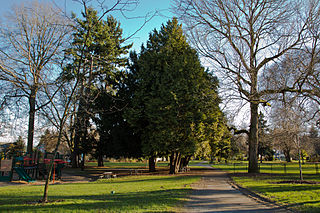
Roanoke Park is a 2.2-acre (0.89 ha) park between the north Capitol Hill and Portage Bay neighborhoods in Seattle, Washington. It occupies the block bounded by E. Edgar and Roanoke Streets on the north and south and 10th Avenue E. and Broadway E. on the east and west, just northeast of the junction of State Route 520 and Interstate 5.

The Gainsboro Branch of the Roanoke City Public Library, also known as the Gainsboro Library, is a historic library building located in the African-American neighborhood of Gainsboro in Northwest Roanoke, Virginia. It was built in 1941-1942, and is a one-story, seven-bay, L-plan Tudor Revival style brick building. The library provided African American residents of Roanoke's segregated Gainsboro neighborhood with a library facility where children and adults could pursue self-education with advice and assistance from competent and dedicated librarians.

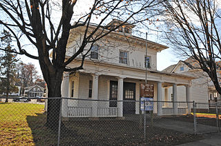
Roanoke City Firehouse No. 6 is a historic fire station located in the Belmont neighborhood of Roanoke, Virginia. It was built in 1911, and is a two-story, three bay, hipped-roof building. It was built to resemble an early-20th century American Foursquare dwelling embellished with Classical Revival details.


