Related Research Articles

This is a list of properties and historic districts in Missouri on the National Register of Historic Places. There are NRHP listings in all of Missouri's 114 counties and the one independent city of St. Louis.

Washington State Park is a public recreation area covering 2,147 acres (869 ha) in Washington County in the central eastern part of the state of Missouri. It is located on Highway 21 about 14 miles (23 km) northeast of Potosi or 7 miles (11 km) southwest of DeSoto on the eastern edge of the Ozarks. The state park is noted for its Native American rock carvings and for its finely crafted stonework from the 1930s.

Mastodon State Historic Site is a publicly owned, 431-acre (174 ha) archaeological and paleontological site with recreational features in Imperial, Missouri, maintained by the Missouri Department of Natural Resources, preserving the Kimmswick Bone Bed. Bones of mastodons and other now-extinct animals were first found here in the early 19th century. The area gained fame as one of the most extensive Pleistocene ice age deposits in the country and attracted scientific interest worldwide.
The McLemore Site, designated by the Smithsonian trinomial 34WA5, is a prehistoric archaeological site of the Southern Plains villagers located near Colony in Washita County, Oklahoma. It is the site of a prehistoric Plains Indian village, dating from AD 1330-1360, during the Washita River phase. The site is of historic importance for being a key element helping determine the chronology of prehistoric cultures in the region. It was declared a National Historic Landmark in 1964.
The Menoken Indian Village Site, also known as Menoken Site, Verendrye Site or Apple Creek Site is an archeological site near Bismarck, North Dakota. The site, that of a fortified village occupied c. 1300, is important in the region's prehistory, as it is one of the only sites that predates sites that are more clearly associated with the historic Hidatsa, Mandan, and Arikara cultures. It was declared a National Historic Landmark in 1964, and was listed on the National Register of Historic Places in 1966. It is located on 171st Street NE, north of Menoken, about 10 miles (16 km) east of Bismarck. The site managed by the state as the Menoken Indian Village State Historic Site, and is open to the public.

Marksville Prehistoric Indian Site, also known as the Marksville site, is a Marksville culture archaeological site located 1 mile (1.6 km) southeast of Marksville in Avoyelles Parish, Louisiana. The site features numerous earthworks built by the prehistoric indigenous peoples of southeastern North America.

The Whiteford (Price) Archeological Site, designated by the Smithsonian trinomial 14SA1, is an archaeological site located in a rural area between Salina and New Cambria, Kansas, United States. As a National Historic Landmark, it is an important Central Plains habitation site, with an unusually well-preserved burial complex. It is on private land, and is not open to the public.

Leary Site, also known as 25-RH-1 or Leary-Kelly Site is an archaeological site near Rulo, Nebraska and the Big Nemaha River. The site now lies entirely on the reservation of the Iowa Tribe of Kansas and Nebraska. The area was once a village and burial site.
This is a list of the National Register of Historic Places listings in Butler County, Ohio.

Graham Cave is a Native American archeological site near Mineola, Missouri in Montgomery County in the hills above the Loutre River. It is located in the 356 acre Graham Cave State Park. The entrance of the sandstone cave forms a broad arch 120 feet (37 m) wide and 16 feet (5 m) high. Extending about 100 feet (30 m) into the hillside, the cave protects an historically important Pre-Columbian archaeological site from the ancient Dalton and Archaic period dating back to as early as 10,000 years ago.

The Osage Village State Historic Site is a publicly owned property in Vernon County, Missouri, maintained by the Missouri Department of Natural Resources. The historic site preserves the archaeological site of a major Osage village, that once had some 200 lodges housing 2,000 to 3,000 people. The site, designated by the Smithsonian trinomial 23VE01, was also known for many years as the Carrington Osage Village Site, under which name it was designated a National Historic Landmark in 1964.

Towosahgy State Historic Site (23MI2), also known as Beckwith's Fort Archeological Site, is a large Mississippian archaeological site with a Woodland period Baytown culture component located in Mississippi County, Missouri, United States. It is believed to have been inhabited from c. 400–1350 CE. The site is maintained by the Missouri Department of Natural Resources as a state historic site. The name Towosahgy is an Osage word which means "old town". It is not known if members of the historic Osage people, who dominated a large area of present-day Missouri at the beginning of the 19th century, ever occupied the site. The site was acquired by the Missouri state park system in 1967 and added to the National Register of Historic Places in 1969 as NRIS number 69000113.
The Renner Village Archeological Site (23PL1) is a prehistoric archaeological site located in the municipality of Riverside, Platte County, Missouri. It was a village site inhabited from approximately 1 CE to 500 CE by peoples of the Kansas City Hopewell culture and through the Woodland period to 1200 CE by peoples of the Middle Mississippian culture. It was added to the National Historic Register on April 16, 1969.

The Campbell Archeological Site (23PM5), is an archaeological site in Southeastern Missouri occupied by the Late Mississippian Period Nodena phase from 1350 to 1541 CE. The site features a large platform mound and village area, as well as several cemeteries. The site was excavated by amateur archaeologist Leo O. Anderson and Professor Carl Chapman from 1954 to 1968 and subsequently published the first material on the site in 1955. The site has yielded the largest number of Spanish artifacts of any prehistoric site in Southeastern Missouri. Finds at the site included glass chevron beads, a Clarksdale bell, iron knife fragments and part of a brass book binder. It was added to the NRHP on July 24, 1974 as NRIS number 74001086.

The Fisher Farm site is an archaeological site in Centre County, Pennsylvania, United States. Located in fields on the outskirts of Unionville, it is one of central Pennsylvania's leading archaeological sites.

This is a list of the National Register of Historic Places listings in Saline County, Missouri.

The Cary Village Site is an archaeological site in the west-central portion of the U.S. state of Ohio. Located southeast of the village of Plain City in Madison County, the site occupies a group of grassy terraces located amid two farm fields. In this grassy area, archaeologists have discovered a wide range of artifacts, including stone tools, materials made of flint, and various types of pottery.
Rodgers Shelter Archeological Site, also known as the Missouri Archaeological Survey Number 23BE125, is a historic archaeological site located at Warsaw, Benton County, Missouri. It is a terrace level archaeological site along the Pomme de Terre River. The site was excavated by R. Bruce McMillan and Raymond Wood before it was submerged by the U. S. Army Corps of Engineers under the water of the Truman Reservoir. The stone tools from the site belong to Late Paleo-Indian (Dalton) Period, Middle Archaic, Late Archaic, and Woodland Period.
Hoecake Village Archeological Site (23MI8) is a historic archeological site located near East Prairie, Mississippi County, Missouri, United States. This site was investigated by archaeologists from the University of Missouri during 1963 and 1967. Almost all of the mounds were leveled before the 1960s. The site includes two surviving burial mounds, which were excavated in 1988. It was added to the National Register of Historic Places in 1972.
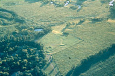
Old Fort, also known as Missouri Archaeological Survey Number 23SA104, is a historic archaeological site located at Van Meter State Park near Miami, Saline County, Missouri. It was first identified in 1879. It is an earthwork embankment dating to the period just before and/or during contact with the first Euro-American explorers.
References
- 1 2 "National Register Information System". National Register of Historic Places . National Park Service. July 9, 2010.
- ↑ Missouri Archaeological Society (November 2005). "National Register of Historic Places Inventory Nomination Form: 23SA128 - Fisher-Gabbert Site". Missouri Archaeological Society. Retrieved February 1, 2017.
