FivePoint Valencia

Last updated

Valencia, California
Old Road & Henry Mayo Valencia.JPG
Valencia with Magic Mountain theme park in background
Coordinates: 34°25′45″N118°36′40″W / 34.42917°N 118.61111°W / 34.42917; -118.61111 Coordinates: 34°25′45″N118°36′40″W / 34.42917°N 118.61111°W / 34.42917; -118.61111
CountryUnited States
State California
County Los Angeles

Valencia is an unincorporated community in Los Angeles County along the Santa Clara River. Launched in the 1960s by Newhall Land, a significant portion of Valencia became the neighborhood of Valencia when the city of Santa Clarita incorporated in 1987. As one of the unincorporated communities surrounding the only city in the Santa Clarita Valley, this area plays a significant role in the local economy as the location of major commerce and industrial parks. The unincorporated Valencia, which straddles State Route 126, is bounded on the west by Ventura County and Interstate 5 on the east, which is also the boundary with the city neighborhood of Valencia.

Contents

Development projects continue to be built in the unincorporated area. A major expansion of Valencia is under construction with new residential neighborhoods and the expansion of commerce and industrial developments. Spanning the Santa Clara River, the massive Newhall Ranch development was conceived by the Newhall Land land management company in the 1980s. After lengthy delays due to environmental challenges and change of investors, the project broke ground in 2017 and was renamed FivePoint-Valencia. Six Flags Magic Mountain and Stevenson Ranch are adjacent to the new development in the south.

History

Original development

Newhall Ranch was ranched and farmed until the 1960s when Newhall Land and Farming Company started a community named after a crop that was grown there, the Valencia orange. [1] The completion of Interstate 5 through the Santa Clarita Valley in 1967 provided an improved route south into the San Fernando Valley. The same year, Newhall Land finished construction of the first homes in Valencia. [2] With stores, parks, hospitals and schools, the community was intended to be self-contained. When it incorporated in 1987, the city of Santa Clarita combined four communities, including most of the built out portion of Valencia, to form a city of 25,000. Although this was the only city, the population of the entire Santa Clarita Valley had reached 125,000. In the late 1980s, Newhall Land had one of the last big parcels of undeveloped real estate near Los Angeles with the 37,250-acre (15,070 ha) Newhall Ranch. [3] They estimated that ten thousand acres (4,000 ha) was developable and about 3,500 acres (1,400 ha) of the master planned Valencia neighborhood had already been built out with 8,000 single-family houses, apartments, and condominiums. Nearly all of the homes were built by the Newhall Land company and they had approvals for some 3,000 additional homes. [1] The area slated for industrial parks, that already had 300 companies and their 8,500 employees, was expanding. Much of the land for industrial and commercial development was sold to other companies to be developed. The first major shopping center opened in 1991. [3] By 1996, 5,000 acres had been developed with some 12,000 homes. [4] In 1998, Valencia area had 1.1 million square feet of industrial space under construction with a 2% vacancy rate in the existing developments. The unincorporated area northwest of the intersection of Interstate 5 and State Route 126 had plenty of acreage and entitlements to accommodate additional industrial space. [5] Named Valencia Commerce Center, the master-planned Business Park is mixed-use with office, industrial and retail. Centered on Commerce Center Drive, major tenants include Remo, Pharmavite, and ITT Aerospace Controls. [6]

Major expansion

The large master-planned Newhall Ranch development in incorporated Valencia, now called FivePoint-Valencia, was conceived in the 1980s by Newhall Land as a greenfield development not included in the original Valencia master plan. During the decades the development has been in planning, it faced legal actions, environmental concerns, and several changes in investors. The landmark California Environmental Quality Act, or CEQA, was used to challenge the development even after the county had approved the specific plan and the zoning changes needed for the project. [7] While these lawsuits have been dismissed as merely tactics to block or delay the project by some, others claim the environmental law has led to a better-designed project while saving crucial habitat. [8]

The project straddles the Santa Clara River, one of the most dynamic river systems in southern California, with the planned area overlapping one of Los Angeles County's Strategic Ecological Areas program, which designates areas of "irreplaceable biological resources". [9] The construction will fill in and alter more than 82 acres (33 ha) of the river's flood plain and tributaries according to the required permits. The area provides habitat for a wide array of native plants and animals including threatened and endangered fauna and flora. [10]

The development includes building 20,885 homes, a commercial district, seven public schools, three fire stations, a regional park, three community parks, a golf course, and a 15-acre (6.1 ha) lake. Ten thousand acres (4,000 ha) of permanent open space would be set aside and 50 miles (80 km) of trails developed. [11] [12] The plan includes converting nearly 20 miles (32 km) of tributaries and riverbank into storm drains and levees and use 20,000,000 cubic yards (15,000,000 m3) of excavated soil to fill in wetlands. [13]

The Newhall Ranch Sanitation District will operate a water reclamation plant serving the development near the boundary with Ventura County. [14] The plant will treat an estimated 6,800,000 US gallons (26,000,000 l; 5,700,000 imp gal) of water every day before releasing it into the Santa Clara River as it flows towards the ocean and into Ventura County. [15] The downstream impact and other effects also drew Ventura County officials and citizens into opposition to the project. [16]

City council members of the adjacent city of Santa Clarita objected to the project in 1989. They were concerned with the congestion it could bring along with the environmental issues that had been raised by other groups. [12] The city was also asking for this area to be included in their sphere of influence, just two years after the city incorporated. [17] The sphere of influence is a municipal growth boundary that delineates the area that the Local Agency Formation Commission (LAFCO) believes is the appropriate and probable future city limit. The proposal to form the city included a much larger area than was finally allowed to proceed by LAFCO. The city applied to LAFCO for similar large increases to the sphere of influence in 1991 and 2000. While the sphere of influence was increased and annexations approved on the other three sides of the city, the western boundary has remained at Interstate 5. Newhall Land supported this limit, stating, "We've always seen the 5 freeway as the dividing line between the city and the county. … There are no city services in that area and it's isolated from the rest of the city." [7]

Several lawsuits have been filed in relation to the Newhall Ranch project over the years by various environmental groups, and Native American tribes. While the development had been in planning for decades and approved by the county, it faced legal actions, environmental concerns, and repeated investor changes. A lawsuit by three environmental groups was settled in 2004. [18] The Lennar Corporation, a national home builder acquired a 15% stake in the company in 2009 with five lenders owning the balance. [19] Lennar formed Five Point Holdings LLC to manage its California master-plan developments in 2009. [20] The developers had hoped to break ground by 2012. [21]

In 2014, the California 2nd District Court of Appeal overturned a Los Angeles County Superior Court ruling and found that the environmental impact report adequately analyzed the project's potential impact on endangered fauna and flora and Native American cultural artifacts. The ruling also supported the agency's determination that storm-drain runoff from the project's 2,587 acres (1,047 ha) into the Santa Clara River would not harm juvenile steelhead trout downstream in Ventura County. [22] [23] Subsequently, the California Supreme Court agreed to review a petition that stated the appellate court opinion exempting developers from protections for the unarmored threespine stickleback would apply to other protected species such as the California Condor. [24] Also of concern is that participation in land-use issues is discouraged by requiring that public comments be submitted early in the environmental review process rather than up to the time of project approval. [25] [26]

The environmental review for the Mission Village neighborhood was upheld by a Los Angeles Superior Court in May 2014. [27] In April 2015, the Appellate court affirmed the environmental review for the Landmark Village neighborhood and approved the commence of the neighborhood's construction. Environmental groups that are still against the project continued challenges in court over Landmark Village. [28]

The California Supreme Court ruled in November 2015 that Newhall Land Development Inc. failed to provide evidence in its overall Environmental Impact Report (EIR) to prove its project was consistent with state guidelines to control greenhouse gases. In May 2016 the state Supreme Court directed lower courts to toss out the EIRs mentioned above for two phases of construction. After changes had been made addressing the Supreme Court's concerns, the California Department of Fish and Wildlife certified the environmental impact report in 2017. [29] [30] In July 2017, the Los Angeles County Board of Supervisors certified a revised environmental analysis and re-approved land-use permits for the Mission Village and Landmark Village communities. [31]

Major construction begins

The development broke ground in 2017, and the company FivePoint is currently developing the first village (Mission Village). [32] [33]

Landmark Village was planned to be the first neighborhood to be built. Mission Village, with 4,000 homes, is currently under construction and will have a "downtown style" mixed-use center. [27] Homestead Village and Portero Village are also being planned.

Entrada South and Entrada North

Entrada South and Entrada North are being developed by Newhall Land as part of their original Valencia Master Plan. The two Entrada projects are west of The Old Road and will abut the Newhall Ranch development on the east with roads connecting to Mission Village.

Entrada South includes 1,574 residential units including 339 homes and 1,235 multi-family units. At just over 500 acres (200 ha), the project also includes 730,000 square feet (68,000 m2) of commercial development, an elementary school, and open space areas. The Newhall Ranch Resource Management and Development Plan and Spineflower Conservation Plan includes approval of a reserve within Entrada South. [34] The development is between Six Flags Magic Mountain amusement park to the north and the community of Westridge to the south which is also part of unincorporated Valencia. [35]

Entrada North is a development with 1,150 multi-family residential units built around a town center with shopping, dining and entertainment. [36] The 479.3-acre (194.0 ha) project is southwest of the junction of Interstate 5 and Highway 126. [37]

Geography

Located in the westerly portion of the Santa Clarita Valley, [38] [39] Valencia has historically supplied people with water, fish, and fertile farmland. The area provides habitat for a wide array of native plants and animals including threatened and endangered fauna and flora such as the California condor, the California gnatcatcher, the southwestern willow flycatcher, the least Bell's vireo, the arroyo toad, the San Fernando Valley spineflower, and the threespine stickleback. [10] The community straddles the Santa Clara River, considered the last undeveloped river valley in Southern California. [10]

Government

The entire Santa Clarita Valley is in the Fifth District of the Los Angeles County Board of Supervisors, represented by Kathryn Barger. [40]

Law enforcement

The California Highway Patrol is responsible for patrolling public streets. [41] The Los Angeles County Sheriff's Department serves the unincorporated Santa Clarita Valley communities together with the city of Santa Clarita which contracts for law enforcement. [42] [43]

See also

Related Research Articles

Valencia, Santa Clarita, California Neighborhood of Santa Clarita in Los Angeles County, California

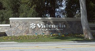
Valencia is a neighborhood in Santa Clarita located within Los Angeles County, California. It is the most populous of the four unincorporated communities that merged to create the city of Santa Clarita in 1987. It is situated in the western part of Santa Clarita, running from Newhall to the south to north of Copper Hill Drive. Valencia was founded as a master-planned community with the first development, Old Orchard I, built on Lyons Avenue behind the Old Orchard Elementary.

Santa Susana Mountains

The Santa Susana Mountains are a transverse range of mountains in Southern California, north of the city of Los Angeles, in the United States. The range runs east-west, separating the San Fernando Valley and Simi Valley on its south from the Santa Clara River Valley to the north and the Santa Clarita Valley to the northeast. The Oxnard Plain is to the west of the Santa Susana Mountains.

Santa Clara River (California) River in Ventura and Los Angeles counties, California

The Santa Clara River is 83 mi (134 km) long, and is one of the most dynamic river systems in Southern California. The river drains parts of four ranges in the Transverse Ranges System north and northwest of Los Angeles, then flows west onto the Oxnard Plain and into the Santa Barbara Channel of the Pacific Ocean.

Santa Clarita Valley Valley in Southern California, US

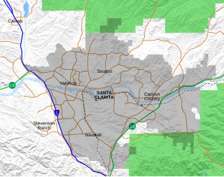
The Santa Clarita Valley (SCV) is part of the upper watershed of the Santa Clara River in Southern California. The valley was part of the 48,612-acre (19,673 ha) Rancho San Francisco Mexican land grant. Located in Los Angeles County, its main population center is the city of Santa Clarita which includes the communities of Canyon Country, Newhall, Saugus, and Valencia. Adjacent unincorporated communities include Castaic, Stevenson Ranch, Val Verde, and the master-planned community of FivePoint Valencia.

California State Route 126 Highway in California

State Route 126 is a state highway in the U.S. state of California that serves Ventura and Los Angeles counties. The route runs from U.S. Route 101 in Ventura to Interstate 5 in Santa Clarita through the Santa Clara River Valley. The highway is an important connector highway in Ventura County, and serves as an alternate route into the Santa Clarita Valley, and the San Fernando Valley area of Los Angeles and the High Desert of Antelope Valley.

Stevenson Ranch, California Place in California, United States

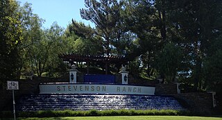
Stevenson Ranch is an unincorporated area in Los Angeles County, California. The community is located in the Santa Clarita Valley. Stevenson Ranch is set in the foothills of the Santa Susana Mountains and lies west of Interstate 5 and the city of Santa Clarita. Stevenson Ranch encompasses about 6.4 square miles (17 km2). About 1,000 acres (4.0 km2) are set aside as parks, recreation areas, and open space. A master-planned community, it was approved by the county in 1987. The population was 17,557 at the time of the 2010 census. For statistical purposes, the Census Bureau has designated it a census-designated place.

Newhall, Santa Clarita, California Community of Santa Clarita in California, United States of America

Newhall is the southernmost and oldest community of Santa Clarita, California. Prior to the 1987 consolidation of Canyon Country, Saugus, Newhall, Valencia and other neighboring communities into the city of Santa Clarita, it was an unincorporated area. It was the first permanent town in the Santa Clarita Valley.

Canyon Country, Santa Clarita, California Neighborhood of Santa Clarita in Los Angeles, California, United States

Canyon Country is a neighborhood in the eastern part of the city of Santa Clarita, in northwestern Los Angeles County, California, United States. It lies along the Santa Clara River between the Sierra Pelona Mountains and the San Gabriel Mountains.

Santa Monica Mountains National Recreation Area protected area in Southern California, USA

The Santa Monica Mountains National Recreation Area is a United States national recreation area containing many individual parks and open space preserves, located primarily in the Santa Monica Mountains of Southern California. The SMMNRA is in the greater Los Angeles region, with two thirds of the parklands in northwest Los Angeles County, and the remaining third, including a Simi Hills extension, in southeastern Ventura County.

Saugus, Santa Clarita, California Neighborhood of Santa Clarita in Los Angeles, California

Saugus is a neighborhood in Santa Clarita, California. It was one of four communities that merged in 1987 to create the city of Santa Clarita. Saugus is named after Saugus, Massachusetts, the hometown of Henry Newhall, upon whose land the town was originally built.

The Newhall School District is a school district in the Santa Clarita Valley that serves the Valencia and Newhall communities within the city of Santa Clarita, California, as well as the Stevenson Ranch community in unincorporated Los Angeles County. As of March 1, 2008, it has 10 elementary schools. The superintendent is Jeff Pelzel.

Golden Oak Ranch Place in California, US

Golden Oak Ranch is an 890-acre (360 ha) movie ranch owned by the Walt Disney Studios subsidiary of The Walt Disney Company that serves as a filming location and backlot. The ranch is off of Placerita Canyon Road outside of Newhall, Santa Clarita, California, less than an hour north of Los Angeles; its entrance is not far from Placerita Canyon Road's intersection with California State Route 14.

Santa Clarita, California City in California, United States

Santa Clarita is a city in northwestern Los Angeles County, California. With an estimated 2019 population of 212,979, it is the third-largest city by population in Los Angeles County, and the 21st-largest in the state of California. It is located about 30 miles (48 km) northwest of downtown Los Angeles, and occupies 70.75 square miles (183.2 km2) of land in the Santa Clarita Valley, along the Santa Clara River. It is a notable example of a U.S. edge city, satellite city, or boomburb.

City of Santa Clarita Transit is a local bus service, administered by the City's transit division, that serves the City of Santa Clarita, California and nearby surrounding unincorporated areas. Daily operations and maintenance of the fleet are under contract with MV Transportation. City of Santa Clarita Transit routes connect with services operated by Metro and Metrolink.

Rancho San Francisco Location of the first discovery of gold in California

Rancho San Francisco was a land grant in present-day northwestern Los Angeles County and eastern Ventura County, California. It was a grant of 48,612 acres (19,673 ha) by Governor Juan B. Alvarado to Antonio del Valle, a Mexican army officer, in recognition for his service to Alta California. It is not related to the city of San Francisco.

Henry Newhall

Henry Mayo Newhall was an American businessman whose extensive land holdings became the Southern California communities of Newhall, Saugus and Valencia, and the city of Santa Clarita.

Newhall Land and Farming Company

The Newhall Land and Farming Company is a land management company based in Valencia, Santa Clarita, California, United States. The company is responsible for the master community planning of Valencia and previously developed other areas such as Canyon Country and Newhall which together with Saugus and Valencia would merge to create the city of Santa Clarita in 1987. The company is also responsible for the management of farm land elsewhere in the state.

Litigation related to climate change and greenhouse gas (GHG) emissions has become increasingly common in federal and state courts. Following adoption of the Global Warming Solutions Act of 2006 and publication of the Intergovernmental Panel on Climate Change (IPCC) Fourth Assessment Report (AR4), additional pressure was placed on California public agencies to evaluate potential adverse effects to global climate change caused by GHG emissions. In particular, several lawsuits have been filed against agencies for failure to analyze GHG emissions generated by projects subject to the California Environmental Quality Act (CEQA). Court decisions prior to the 2010 revisions to the CEQA guidelines gave early insights as to how CEQA would be used as a vehicle to identify and mitigate GHG emissions within the state. Decisions issued after adoption of the revised guidelines are now being used to interpret CEQA's new requirement to evaluate GHG emissions and climate change.

Centennial, California is a proposed 12,323-acre (49.87 km2) master-planned community on Tejon Ranch, in Los Angeles County between Bakersfield and Los Angeles. It is situated in the far western Antelope Valley at the foothills of the Sierra Pelona and Tehachapi Mountains. The proposed community will be built along California State Route 138 east of Interstate 5 and northeast of Quail Lake.

Lang Southern Pacific Station

Lang station is a former Southern Pacific railway station located in Soledad Canyon in Canyon Country, Santa Clarita, California. On September 5, 1876 the first railway to Los Angeles was completed at this site. The Lang Southern Pacific Station was designated a California Historic Landmark on May 22, 1957.

References

  1. 1 2 Peltz, James F. (July 28, 1987). "Newhall Land Seeks to Grow, but Roots Remain in Valencia". Los Angeles Times. Retrieved March 16, 2021.
  2. "Interstate 5 Construction, Grapevine Area". scvhistory.com. Retrieved March 21, 2021.
  3. 1 2 Peltz, James F. (June 21, 1988). "37,000-Acre Asset : Value of Newhall Ranch at Heart of Investor Dispute". Los Angeles Times. Retrieved March 16, 2021.
  4. Brooks, Nancy Rivera (February 5, 1996). "A Developer Hits Pay Dirt". Los Angeles Times. Retrieved March 21, 2021.
  5. Howard, Bob (June 9, 1998). "Valencia Wins Attention as an Industrial Center". Los Angeles Times. Retrieved March 12, 2021.
  6. "SCV Business Parks". Santa Clarita Valley Economic Development Corp. Retrieved March 23, 2021.
  7. 1 2 Shigley, Paul (January 1, 2001). "City, County Continue Battle For Control Of Santa Clarita Valley". California Planning & Development Report. Retrieved April 4, 2021.
  8. Khouri, Andrew (August 7, 2014) "San Pedro project illustrates a cause of limited housing affordability" Los Angeles Times
  9. "SEA Program – Significant Ecological Areas Program" . Retrieved October 7, 2020.
  10. 1 2 3 Sahagun, Louis (March 6, 2014). "Newhall Ranch project faces new hurdles with environmentalists' suit". Los Angeles Times.
  11. Alvarenga, Emily (March 11, 2021). "L.A. County Supes OK Valencia Project Updates". Santa Clarita Valley Signal. Retrieved March 20, 2021.
  12. 1 2 SANDOVAL, GREG (January 11, 1997). "Santa Clarita Prepares to Oppose Newhall Ranch". Los Angeles Times. Retrieved July 15, 2016.
  13. Sahagun, Louis (February 3, 2011). "EPA, Army Corps of Engineers are at odds over Newhall Ranch". Los Angeles Times. Retrieved June 13, 2011.
  14. Alvarenga, Emily (March 9, 2021). "Supes to discuss Valencia housing development". Santa Clarita Valley Signal. Retrieved March 9, 2021. ...the Valencia project, formerly known as Newhall Ranch.
  15. Holt, Jim (August 17, 2010 - Updated: August 18, 2010) "High cost of compliance" The Santa Clarita Valley Signal Retrieved April 10, 2014.
  16. Barlow, Zeke (December 27, 2011). "Newhall's impact on Ventura County debated". Ventura County Star . Retrieved July 15, 2016.
  17. Padilla, Steve (June 14, 1989). "Santa Clarita Seeks Huge Sphere of Influence". Los Angeles Times. Retrieved April 4, 2021.
  18. Haynes, Karima (April 1, 2004). "Suit Settlement Clears the Way for Newhall Ranch". Los Angeles Times. Retrieved April 1, 2004.
  19. Hong, Peter (July 21, 2009). "Lennar Corp buy 15% stake in Newhall Ranch development at big discount". Los Angeles Times. Retrieved July 21, 2009.
  20. Li, Roland (April 10, 2017). "Lennar's California megadeveloper spinoff files to go public". San Francisco Business Times. Retrieved March 15, 2021.
  21. Billingsley, Eric (January 18, 2010). "Newhall Land Plots Strategy After Turbulent Times". San Fernando Valley Business Journal. Retrieved January 18, 2010.
  22. Sahagun, Louis (March 20, 2014). "Court clears way for Newhall Ranch project to proceed". Los Angeles Times. Retrieved March 21, 2014.
  23. Coon, Arthur F. (April 4, 2014) "Second District Addresses Interesting CEQA and CESA Species Mitigation Issues in Lengthy Partially Published Opinion Upholding Resource Management and Conservation Approvals for Newhall Ranch Project, but "Hides its Work" on Significant Greenhouse Gas Issues in Unpublished Portion" CEQA Developments. Miller Starr Regalia Retrieved 14 July 2014
  24. Fausset, Richard; Riccardi, Nicholas (March 6, 2003). "Developers' Control Over Studies Debated". Los Angeles Times . Retrieved July 15, 2016.
  25. Sahagun, Louis (July 11, 2014). "California Supreme Court to review opinion in Newhall Ranch dispute". Los Angeles Times.
  26. Coon, Arthur F. (July 11, 2014) "Supreme Court's CEQA Docket Expands With Grant of Review in Newhall Ranch Case" CEQA Developments. Miller Starr Regalia Retrieved 14 July 2014
  27. 1 2 Madler, Mark (27 May 2014) "Newhall Ranch Wins Legal Round" San Fernando Valley Business Journal
  28. Holt, Jim (April 22, 2015). "Appellate court affirms Newhall Ranch's Landmark Village". Santa Clarita Signal . Retrieved June 17, 2017.
  29. "Newhall Ranch Resource Management and Development Plan and Spineflower Conservation Plan". California Department of Fish and Wildlife. Retrieved April 5, 2021.
  30. Sahagun, Louis (June 15, 2017). "State officials clear a roadblock to the controversial Newhall Ranch development". Los Angeles Times . Retrieved June 17, 2017.
  31. Agrawal, Nina (July 18, 2017). "Long-debated Newhall Ranch project gets key approvals from county". LA Times . Retrieved October 25, 2017.
  32. Collins, Jeff (January 14, 2020). "New homes on horizon following $135 million sale of Valencia lots". Daily News. Retrieved March 12, 2021.
  33. Khouri, Andrew (May 10, 2017). "Developer of Great Park, Newhall Ranch has mixed debut on public market". Los Angeles Times. Retrieved March 18, 2021.
  34. "Project No. 00-210-(5) / Vesting Tentative Tract Map No. 53295 / Entrada South". Department of Regional Planning | Case & Hearing. Los Angeles County. Retrieved March 28, 2021.
  35. Worden, Leon (May 9, 2015). "1,574 Homes to Fill Gap Between Westridge, Magic Mountain". SCVNews.com. Retrieved March 31, 2021.
  36. Worden, Leon (March 13, 2015). "Review Process Starts for Newhall Land's 'North Entrance' with Town Center". SCVNews.com. Retrieved March 31, 2021.
  37. Holt, Jim (April 28, 2018). "County continues housing plans for development". Santa Clarita Valley Signal. Retrieved March 28, 2021.
  38. Hamilton, Denise (April 3, 1988). "Homes on the Range : Developers Pushing Ranchers Out". Los Angeles Times . Retrieved July 15, 2016.
  39. Newhall., Ruth Waldo (February–March 1997). "How Santa Clarita Got Its Name". Old Town Newhall Gazette. Retrieved March 22, 2018 via www.scvhistory.com.
  40. "Kathryn Barger, Los Angeles County Supervisor,". SCVHistory.com. Retrieved March 22, 2021.
  41. "(540) Newhall". California Highway Patrol. Retrieved March 19, 2021.
  42. "Santa Clarita Station". Los Angeles County Sheriff's Department. Retrieved March 19, 2021.
  43. Agrawal, Nina (May 9, 2018). "Santa Clarita opposes California's 'sanctuary' law, the first city in L.A. County to do so". Los Angeles Times. Retrieved March 19, 2021. Santa Clarita contracts with the L.A. County Sheriff’s Department for law enforcement services and is bound by that department’s policies...