
The Arkansas Post, formally the Arkansas Post National Memorial, was the first European settlement in the Mississippi Alluvial Plain and present-day U.S. state of Arkansas. In 1686, Henri de Tonti established it on behalf of Louis XIV of France for the purpose of trading with the Quapaw Nation. The French, Spanish, and Americans, who acquired the territory in 1803 with the Louisiana Purchase, considered the site of strategic value. It was the capital of Arkansas from 1819 until 1821 when the territorial government relocated to Little Rock.

Fort Monroe is a former military installation in Hampton, Virginia, at Old Point Comfort, the southern tip of the Virginia Peninsula, United States. It is currently managed by partnership between the Fort Monroe Authority for the Commonwealth of Virginia, the National Park Service, and the city of Hampton as the Fort Monroe National Monument. Along with Fort Wool, Fort Monroe originally guarded the navigation channel between the Chesapeake Bay and Hampton Roads—the natural roadstead at the confluence of the Elizabeth, the Nansemond and the James rivers.

Old Las Vegas Mormon Fort State Historic Park is a state park of Nevada, containing the Old Mormon Fort, the first structure built by people of European heritage in what would become Las Vegas fifty years later. In present-day Las Vegas, the site is at the southeast corner of Las Vegas Boulevard and Washington Avenue, less than one mile north of the downtown area and Fremont Street. This is the only U.S. state park located in a city that houses the first building ever built in that city. The fort was listed on the National Register of Historic Places on February 1, 1972. The site is memorialized with a tablet erected by the Church of Jesus Christ of Latter-day Saints in 1997, along with Nevada Historical Marker #35, and two markers placed by the Daughters of Utah Pioneers.
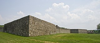
Fort Frederick State Park is a public recreation and historic preservation area on the Potomac River surrounding the restored Fort Frederick, a fortification active in the French and Indian War (1754–1763) and the American Revolutionary War (1775-1783). The state park lies south of the town of Big Pool, Maryland. The Chesapeake and Ohio Canal runs through the park grounds. The site was designated a National Historic Landmark in 1973.

The Kilgore Fort House is a historic site located in Scott County, Virginia at 190 West Jackson Street, Gate City, Virginia. Fort houses were built to provide protection for individual families during the period from 1773 to about 1795 when attacks by Native Americans on the pioneer settlers were common. The Kilgore Fort House was built about 1790 by the Reverend Robert Kilgore, and is the only surviving example of its type in southwest Virginia.

Werowocomoco was a village that served as the headquarters of Chief Powhatan, a Virginia Algonquian political and spiritual leader when the English founded Jamestown in 1607. The name Werowocomoco comes from the Powhatan werowans (weroance), meaning "leader" in English; and komakah (-comoco), "settlement". The town was documented by English settlers in 1608 as located near the north bank of the York River in what is now Gloucester County. It was separated by that river and the narrow Virginia Peninsula from the English settlement of Jamestown, located on the James River.

The Sycamore Shoals of the Watauga River, usually shortened to Sycamore Shoals, is a rocky stretch of river rapids along the Watauga River in Elizabethton, Tennessee. Archeological excavations have found Native Americans lived near the shoals since prehistoric times, and Cherokees gathered there. As Europeans began settling the Trans-Appalachian frontier, the shoals proved strategic militarily, as well as shaped the economies of Tennessee and Kentucky. Today, the shoals are protected as a National Historic Landmark and are maintained as part of Sycamore Shoals State Historic Park.

Prickett's Fort State Park is a 188-acre (76.1 ha) West Virginia state park north of Fairmont, near the confluence of Prickett's Creek and the Monongahela River. The park features a reconstructed refuge fort and commemorates life on the Virginia frontier during the late 18th century.
This is a list of the National Register of Historic Places listings in Knox County, Tennessee.

Smith's Fort Plantation is a house and parcel of land located in Surry County, Virginia, United States. The current main house on the property, also known as the Faulcon House, dates from 1751. The house has been an example for numerous twentieth century reproductions. It is also known as Warren House and Rolfe-Warren House.
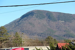
Fort Mountain is a mountain in northern Georgia, just east of Chatsworth. It is part of the Cohutta Mountains, a small mountain range at the southern end of the Appalachian Mountains. It also lies within the Chattahoochee National Forest.

The Petersburg Breakthrough Battlefield is a historic district in Dinwiddie County, near Petersburg, Virginia. It was the location of the Third Battle of Petersburg, in which the Union Army broke through Confederate Army lines protecting Petersburg and Richmond on April 2, 1865, during the American Civil War. The success of the breakthrough led to abandonment of Richmond by General Robert E. Lee, a general retreat, and surrender at Appomattox Court House one week later. Portions of the area were listed on the National Register of Historic Places in 2003, and a different portion was designated a National Historic Landmark in 2006. Much of the battlefield area is part of Pamplin Historical Park, a private park open to the public that interprets the battle. The park includes a full-service visitor center, trails, displays, interpretive signs and history programs. The Civil War Trust and its partners have acquired and preserved 407 acres (1.65 km2) of the Breakthrough battlefield in five transactions since 2004.
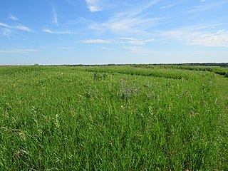
Van Meter State Park is a public recreation area on the Missouri River in Saline County, Missouri. The state park consists of 1,105 acres (447 ha) of hills, ravines, fresh water marsh, fens, and bottomland and upland forests in an area known as "the Pinnacles." The park has several archaeological sites, a cultural center, and facilities for camping, hiking, and fishing. It is managed by the Missouri Department of Natural Resources.

Fort Van Meter — or Fort VanMeter — is a mid-18th century frontier fort in the South Branch Potomac River Valley about 9 miles (14 km) southwest of Romney in Hampshire County, West Virginia, USA. It is located 15 miles (24 km) northeast of Moorefield and about a mile northeast of the former community of Glebe at the northern end of the rugged river gorge known as The Trough.
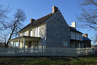
Daniel Harrison House, also known as Fort Harrison, is a historic home located near Dayton, Rockingham County, Virginia. The original structure was built in 1748 as a two-story, three bay limestone dwelling, with a steep gable roof and wide chimney caps. A brick extension was added in the early 1800s. It was originally surrounded by a palisade and was reported to have an underground passage to the nearby spring. During the French and Indian War, the legislature of Virginia designated the house and surrounding property "Fort Harrison." The house is one of the oldest in the Shenandoah Valley, and is closely associated with the early history of Rockingham County.

Hupp House, also known as the Frontier Fort and Hupp Homestead, is a historic home located in Strasburg, Shenandoah County, Virginia. It was built about 1755, and is a 4-story, rubble limestone Colonial-era dwelling. It is on a banked site and measures 20 feet wide by 40 feet deep. A concrete block east wing was added in 1956. The house has a steep gable roof and features a traditional Germanic central chimney and the interior framing appears original, with heavy traditional Germanic beams and roof structure. It is one of the oldest extant dwellings erected by Germanic settlers in Shenandoah County.

Fort Bowman, also known as Harmony Hall, is a historic home and national historic district located near Middletown, Frederick County, Virginia. It was built in 1753, by Pennsylvania German settler George Bowman (1699–1768), father of Colonel John Bowman (1738-1784), Colonel Abraham Bowman (1749-1837), Major Joseph Bowman, and Captain Isaac Bowman (1757-1826). It is a two-story, rectangular limestone building with a gable roof. The interior retains its original woodwork. It has a later kitchen wing and iron and wood portico. Also on the property are a contributing dairy / smokehouse and the Bowman graveyard, which includes the grave of Isaac Bowman.

Fort Norfolk is a historic fort and national historic district located at Norfolk, Virginia. With the original buildings having been built between 1795 and 1809, the fort encloses 11 buildings: main gate, guardhouse, officers' quarters, powder magazine, and carpenter's shop. Fort Norfolk is the last remaining fortification of President George Washington's 18th century harbor defenses, later termed the first system of US fortifications. It has served as the district office for the U.S. Army Engineer District, Norfolk since 1923.

Valley Railroad Bridge or Gish Branch Bridge is a historic limestone arch bridge located over Gish Branch at Salem, Virginia. It was built in 1873 by the firm of Claiborne Rice (C.R.) Mason, under the local guidance of Thomas Menifee, engineer and employee of Mason. Mason was head of a syndicate hoping to link major railways of the north and south at Salem, Virginia - specifically by linking the Atlantic, Mississippi and Ohio Railroad with the Baltimore and Ohio Railroad, two of the major railways of the era.
Fort Juelson, designated 21OT198 in the state archaeological inventory, is a historic site located east of Underwood, Minnesota, United States. An earthen fort was built at this hilltop in July 1876 after rumors of Indian attacks in Foxhome, French, and Fergus Falls following the Battle of Little Bighorn in Montana. Many settlers left the area. Charles A. Dollner, a local merchant, suggested the rest of the people band together and build the fortification under leadership of two American Civil War veterans, Hans Juelson and Berge O. Lee. The scare proved to be a hoax, and the fort was never used for defensive purposes. Remnants of the sod barricade are still on the site.


