The Presidio of San Francisco is a park and former U.S. Army post on the northern tip of the San Francisco Peninsula in San Francisco, California, and is part of the Golden Gate National Recreation Area.

Muir Woods National Monument is a United States National Monument managed by the National Park Service and named after naturalist John Muir. It is located on Mount Tamalpais near the Pacific coast in southwestern Marin County, California. The Monument is part of the Golden Gate National Recreation Area, and is 12 miles (19 km) north of San Francisco. It protects 554 acres (224 ha), of which 240 acres (97 ha) are old growth coast redwood forests, one of a few such stands remaining in the San Francisco Bay Area.

Fort Point, known historically as the Castillo de San Joaquín is a masonry seacoast fortification located on the southern side of the Golden Gate at the entrance to San Francisco Bay. It is also the geographic name of the promontory upon which the fort and the southern approach of the Golden Gate Bridge were constructed.

The Marin Headlands are a hilly peninsula at the southernmost end of Marin County, California, United States, located just north of San Francisco across the Golden Gate Bridge, which connects the two counties and peninsulas. The entire area is part of the Golden Gate National Recreation Area. The Headlands are famous for their views of the Bay Area, especially of the Golden Gate Bridge.

SF-88 is a former Nike Missile launch site at Fort Barry, in the Marin Headlands to the north of San Francisco, California, United States. Opened in 1954, the site was intended to protect the population and military installations of the San Francisco Bay Area during the Cold War, specifically from attack by Soviet bomber aircraft.

Fort Mason, in San Francisco, California is a former United States Army post located in the northern Marina District, alongside San Francisco Bay. Fort Mason served as an Army post for more than 100 years, initially as a coastal defense site and subsequently as a military port facility. During World War II, it was the principal port for the Pacific campaign.

The Golden Gate National Recreation Area (GGNRA) is a U.S. National Recreation Area protecting 82,116 acres (33,231 ha) of ecologically and historically significant landscapes surrounding the San Francisco Bay Area. Much of the park is land formerly used by the United States Army. GGNRA is managed by the National Park Service and is the second-most visited unit of the National Park system in the United States, with more than 15.6 million visitors in 2022. It is also one of the largest urban parks in the world, with a size two-and-a-half times that of the consolidated city and county of San Francisco.

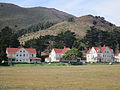
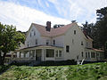
Fort Baker is one of the components of California's Golden Gate National Recreation Area. The Fort, which borders the City of Sausalito in Marin County and is connected to San Francisco by the Golden Gate Bridge, served as an Army post until the mid-1990s, when the headquarters of the 91st Division moved to Parks Reserve Forces Training Area. It is located opposite Fort Point at the entrance to the San Francisco Bay.

Established in 1917, the Presidio Fire Department provides primary emergency response to the Presidio of San Francisco.
The Fort Miley Military Reservation, in San Francisco, California, sits on Point Lobos, one of the outer headlands on the southern side of the Golden Gate. Much of the site is part of the Golden Gate National Recreation Area, while the grounds and buildings that were converted into the San Francisco VA Medical Center are administered by the Veterans Health Administration of the US Department of Veterans Affairs.
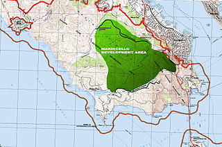
Marincello was a failed development project in Marin County, California that would have put a planned community atop the Marin Headlands, overlooking the Golden Gate. Its upheaval set the precedent for Marin County's rigid anti-development stance and push for open space.

Fort Funston is a former harbor defense installation located in the southwestern corner of San Francisco. Formerly known as the Lake Merced Military Reservation, the fort is now a protected area within the Golden Gate National Recreation Area (GGNRA) and is used widely as an off-leash dog park. It was named in honor of Frederick N. Funston (1865–1917), a Major General in the United States Army with strong connections to San Francisco, and included several artillery batteries. The fort is located on Skyline Boulevard at John Muir Drive, west of Lake Merced.

The Sutro Historic District is a National Park Service historic district in the Lands End area of the Outer Richmond District in western San Francisco, California. It is within the Golden Gate National Recreation Area, since being acquired by the National Park Service in 1977.
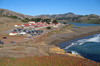
Fort Cronkhite is one of the components of California's Golden Gate National Recreation Area. Today part of the National Park Service, Fort Cronkhite is a former US Army post that served as part of the coastal artillery defenses of the San Francisco Bay Area during World War II. The soldiers at Cronkhite manned gun batteries, radar sites, and other fortifications on the high ridges overlooking the fort.

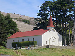
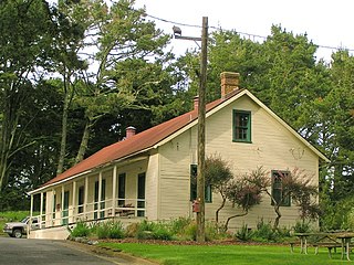
Fort Barry is a former United States Army installation on the West Coast of the United States, located in the Marin Headlands of Marin County, California, north of San Francisco. Opened 116 years ago in 1908, the fort was part of the Coast Artillery Corps and operated throughout the 20th century, before its closure and eventual transfer to the National Park Service.
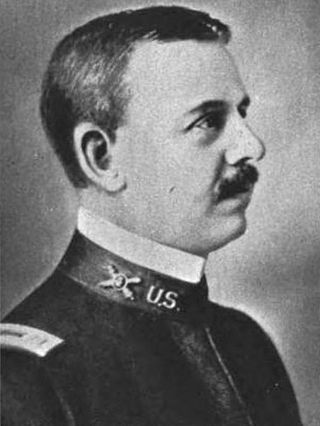
Adelbert Cronkhite was a career officer in the United States Army. He was notable for his command of the 80th Division during World War I. He also served as interim commander of IX Corps and commander of VI Corps after the war. In addition, his later command assignments included the Newport News Port of Debarkation, the Coast Artillery Training Center, and Third Corps Area.
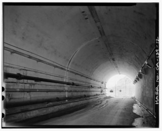
The Baker–Barry Tunnel connects the former military bases Fort Barry and Fort Baker in the Marin Headlands of Marin County, California. The bases are now part of the Golden Gate National Recreation Area. The tunnel is also known as the Bunker Road Tunnel for the road that runs through it, or as the Five-Minute Tunnel because it is only wide enough to accommodate a single reversible lane, opened to traffic at either end for five minute intervals.

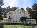
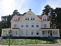
Cavallo Point is a conference center or hotel in Marin County, California. It is located within Fort Baker in the Golden Gate National Recreation Area. It is also known as the Lodge at the Golden Gate.