
The Cuyuna Iron Range Municipally-Owned Elevated Metal Water Tanks are a group of five water towers within the Cuyuna Range in Crow Wing County, Minnesota. The water tanks, built between 1912 and 1918, were listed on the National Register of Historic Places because they represent the historical period of community planning, public works, and engineering that supported the development of the Cuyuna Range. Their construction was made possible by a favorable property tax arrangement on the iron mines that brought significant revenues to the towns of Crosby, Cuyuna, Deerwood, Ironton, and Trommald. The communities began around 1910, when iron mining started on the Range. The peak of mining employment was around 1920, and it started to decline around 1930. By the 1950s, iron mining was well in decline on the Cuyuna Range. As of 2022, it appears only two of the water tanks survive at their original locations.

This is a list of the National Register of Historic Places listings in Detroit, Michigan.

The Grand Loop Road is a historic district which encompasses the primary road system in Yellowstone National Park. Much of the 140-mile (230 km) system was originally planned by Captain Hiram M. Chittenden of the US Army Corps of Engineers in the early days of the park, when it was under military administration. The Grand Loop Road provides access to the major features of the park, including the Upper, Midway and Lower geyser basins, Mammoth Hot Springs, Tower Fall, the Grand Canyon of the Yellowstone and Yellowstone Lake.
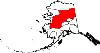
This is a list of the National Register of Historic Places listings in Yukon–Koyukuk Census Area, Alaska.

John Everett Tourtellotte was a prominent western American architect, best known for his projects in Idaho. His work in Boise included the Idaho State Capitol, the Boise City National Bank, the Carnegie Library, and numerous other buildings for schools, universities, churches, and government institutions. From 1922 to 1930, he worked in Portland, Oregon.

Lescher & Mahoney was an American architectural firm from Phoenix, Arizona.
The Kilauea Plantation or Kilauea Sugar Plantation was a large sugarcane plantation on the north side of Kauai island, Hawaii, including the community of Kilauea, Hawaii. It was owned and operated by the 1880-incorporated Kilauea Sugar Company, which became the Kilauea Sugar Plantation, Co. from 1899 on. The original property was bought by an American, Charles Titcomb, from Kamehameha IV by 1863 who used it for cattle ranching. It was sold to Englishmen John Ross and E.P. Adams, who also leased additional land from Titcomb. Ross and Adams planted sugarcane, then incorporated a firm. It was operated as a plantation from 1880 to 1971.
This is a list of Registered Buildings and Conservation Areas of the Isle of Man. It includes buildings and structures in the Isle of Man designated by Isle of Man's Department of Environment, Food and Agriculture (DEFA) "as having special architectural or historical interest". Over 250 buildings and structures are listed, and 275 more have been identified as having potential for listing. It also lists the 21 Conservation Areas, historic districts" which protect "period"-type architecture, quality of building materials, relationships of enclosures and open spaces, and other aspects of the look and feel of historic buildings and areas.

North Chatham Historic District is a historic district consisting of most or all of the hamlet of North Chatham in Columbia County, New York. It was listed on the National Register of Historic Places in 2023.

The Lewis Bungalow, the Lewis Barn, and the Fred Lewis Cottage, all located on W. 2nd North in Paris, Idaho were listed on the National Register of Historic Places.
Slob Historic District, near Christiansted, Virgin Islands, is a historic district which was listed on the National Register of Historic Places in 1987. The listing included nine contributing buildings, three contributing structures, and a contributing site on 9 acres (3.6 ha).
The Clarkston Tithing Granary, at 10212 N. 8700 West in Clarkston, Utah was built in 1905 to house in kind tithing donations by the Church of Jesus Christ of Latter-day Saints. It was listed on the National Register of Historic Places in 1985.
The House at 577 Deer Valley Road, at 577 Deer Valley Rd. in Park City, Utah, was built in 1890. It was listed on the National Register of Historic Places in 1984.

The Ecker Hill Ski Jump, in Summit County, Utah near Snyderville, Utah, was built in 1928. It was listed on the National Register of Historic Places in 1986.

The Henry M. Hinsdill House, at 662 Norfolk St. in Park City, Utah, was probably built around 1893. It was listed on the National Register of Historic Places in 1984.
The Shivers-Simpson House, also known as Rock Mill, on the west bank of the Ogeechee River in Hancock County, Georgia, near Jewell, Georgia, was built around 1820. It was listed on the National Register of Historic Places in 1970.
Roy F. France (1888-1972) was the American architect who is credited with creating the Miami Beach, Florida skyline.
The Roswell Historic District, in Roswell, Georgia in Fulton County, was listed on the National Register of Historic Places in 1974.
The Bird's Nest is a historic residence built c.1850 in Shelby County, Kentucky, about 3 miles (4.8 km) south of Cropper, Kentucky. It is listed on the National Register of Historic Places since 1988. The NRHP listing included two other contributing buildings and a non-contributing building.
The Grimes House and Mill Complex, located on Boone's Creek in Fayette County, Kentucky, near Lexington, Kentucky, dates from 1813. It was listed on the National Register of Historic Places in 1982. It is historically significant in that it is considered to be one of the "most important early commercial buildings remaining in central Kentucky."

